

This is an excerpt from the full report which can be downloaded below
Third Integrated Report on the Eutrophication Status of the OSPAR Maritime Area
Executive Summary
Eutrophication is still a problem
The overall objective of the OSPAR Eutrophication Strategy is to achieve a healthy marine environment where no eutrophication occurs. To determine progress towards the objective, the OSPAR Common Procedure was applied by nine Contracting Parties for a third time in 2017, using data from 2006 to 2014. This application indicates that the strategic objective has not yet been achieved. Eutrophication is still a problem in 7% of the North-East Atlantic, mainly affecting coastal areas. The Greater North Sea had the largest problem area (approximately 98,000km2) with respect to eutrophication, extending along the coast from Belgium to Danish and Swedish waters. Small problem areas (5 to 400 km2) were found along the coast of France, Norway and the United Kingdom. In the Celtic Seas many small inshore and coastal areas were classified as problem areas (approximately 500 km2). In the Bay of Biscay two problem areas (approximately 800 km2) were identified.
Full Report
Positive trends observed
Between applications of the Common Procedure in 2008 and 2017 the spatial extent of problem areas has decreased in Denmark, France, Germany, Ireland, Norway and the United Kingdom. For Belgium and the Netherlands it remained constant. For Sweden there was a small increase in the extent of problem areas, as a greater area was assessed in 2017 compared to previous applications. The total spatial extent of problem areas has decreased from nearly 169,000km2 in 2003 to 119,000km2 in 2008 and 100,000 km2 in 2017. The extent of potential problem areas has decreased from 2008 to 2017 and some of these are former problem areas that are showing improvements. Eutrophication status improved mainly in offshore and outer coastal waters of the Greater North Sea, in particular in Danish waters and in the Skagerrak, while there were a few improvements in inner coastal and inshore waters.
Significant nutrient input reductions
Improvements in eutrophication status are largely dependent on reducing anthropogenic inputs of nitrogen and phosphorus into problem areas. Contracting Parties have made great efforts to reduce nutrient inputs since the 1980s. OSPAR initiatives, together with actions under EU Directives and the Gothenburg Protocol of UNECE Convention on Long-range Transport of Air Pollution (CLRTAP), have resulted in substantial reductions of up to 50% in some areas. Inputs of phosphorus to the Greater North Sea, the Celtic Seas, the Bay of Biscay and the Iberian Shelf have all reduced since 1990. However, the rate of decrease in phosphorus inputs to the Greater North Sea has slowed since 2003. Nitrogen inputs have also reduced, by up to 25% in the case of the Greater North Sea. Of particular note is that atmospheric nitrogen inputs have reduced by 30% since 1990.
Although Contracting Parties have substantially decreased nutrient inputs, this has not yet resulted in an improvement of the overall eutrophication status. The main reason is that improvements in eutrophication effects parameters (chlorophyll concentrations, abundance of phytoplankton indicator species, oxygen depletion) happen slowly as a result of time lags in the marine system.
Further efforts are needed
Further effort is needed to reduce nutrient inputs in particular for nitrogen into the marine environment. Transboundary nutrient transport, both between Contracting Parties and from outside the OSPAR maritime area, remains a challenge, since nutrient reduction requirements are not only driven by the eutrophication status of Contracting Parties’ own waters but also need to consider nutrients exported to the waters of other Contracting Parties. OSPAR’s ecological modelling group ICG-EMO is working to improve quantification of transboundary nutrient fluxes. Some modelling studies estimate that nutrient input reductions beyond the current objective of the Eutrophication Strategy of a 50% reduction in anthropogenic loads in relation to input levels in 1985 will be needed to convert all problem areas into non-problem areas.
Experience gained in applying the Common Procedure
The Common Procedure has proved a good operational tool for the assessment of the eutrophication status and a useful instrument for addressing the requirements of the Marine Strategy Framework Directive (2008/56/EC).
A further application of the Common Procedure is necessary to follow up the effectiveness of reduction measures within OSPAR and under relevant EU regimes, for the eutrophication status of the North-East Atlantic. Contracting Parties have identified a number of issues concerning the Common Procedure that need to be addressed before its fourth application. Among them are: differences in assessment levels that result in contrasting classifications; the need to identify improvements in areas that have not yet achieved non-problem area status; remaining disparities between the Common Procedure and the Water Framework Directive; the need to make the fourth application less resource-intensive, and; technical issues relating to data analysis and emerging technologies such as automatic systems and remote sensing.
Figure 1: Eutrophication status in areas assessed under the third application of the Common Procedure (2006–2014) in terms of problem areas, potential problem areas and non-problem areas: (a) whole area assessed, (b) Celtic Sea, (c) Greater North Sea, and (d) Bay of Biscay. For Ireland, Norway and the United Kingdom’s inshore and coastal waters the locations of problem areas and potential problem areas are illustrated with circles, because these assessed areas are too small to be seen if their actual area extent is mapped
Data are available on ODIMS via: https://odims.ospar.org/layers/geonode:ospar_eut_status_2017_06_001
Introduction
This report is the third in a series of periodic assessments of the eutrophication status of the OSPAR Maritime Area under the Common Procedure for the Identification of the eutrophication status of the OSPAR Maritime Area (the “Common Procedure”) (OSPAR, 2013). It follows and builds on the results of the first and second applications of the Comprehensive Procedure (OSPAR, 2003a, 2008). The thematic assessment contributes to the OSPAR Intermediate Assessment 2017, which may be used by OSPAR Contracting Parties in support of the requirements of the European Union (EU) Marine Strategy Framework Directive (2008). The purpose of this report is:
- to assess the eutrophication status of the OSPAR Maritime Area and its Regions based on data for the period 2006–2014;
- to evaluate progress made towards achieving the objectives of the OSPAR Eutrophication Strategy;
- to consider the effectiveness of measures taken to combat eutrophication on the state of the marine environment, and;
- to identify priorities for future actions.
The following Contracting Parties conducted a third application of the Comprehensive Procedure: Belgium, Denmark, France, Germany, Ireland, the Netherlands, Norway, Sweden and the United Kingdom.
Eutrophication Strategy
OSPAR’s North East Atlantic Environment Strategy (OSPAR, 2010) takes forward work related to the implementation of the Ecosystem Approach and the suite of five thematic strategies, to address the main threats that it has identified concerning issues within its competence. The aim of the OSPAR Eutrophication Strategy is to make every effort to combat eutrophication in the OSPAR Maritime Area in order to achieve and maintain, by 2020, a healthy marine environment where eutrophication does not occur.
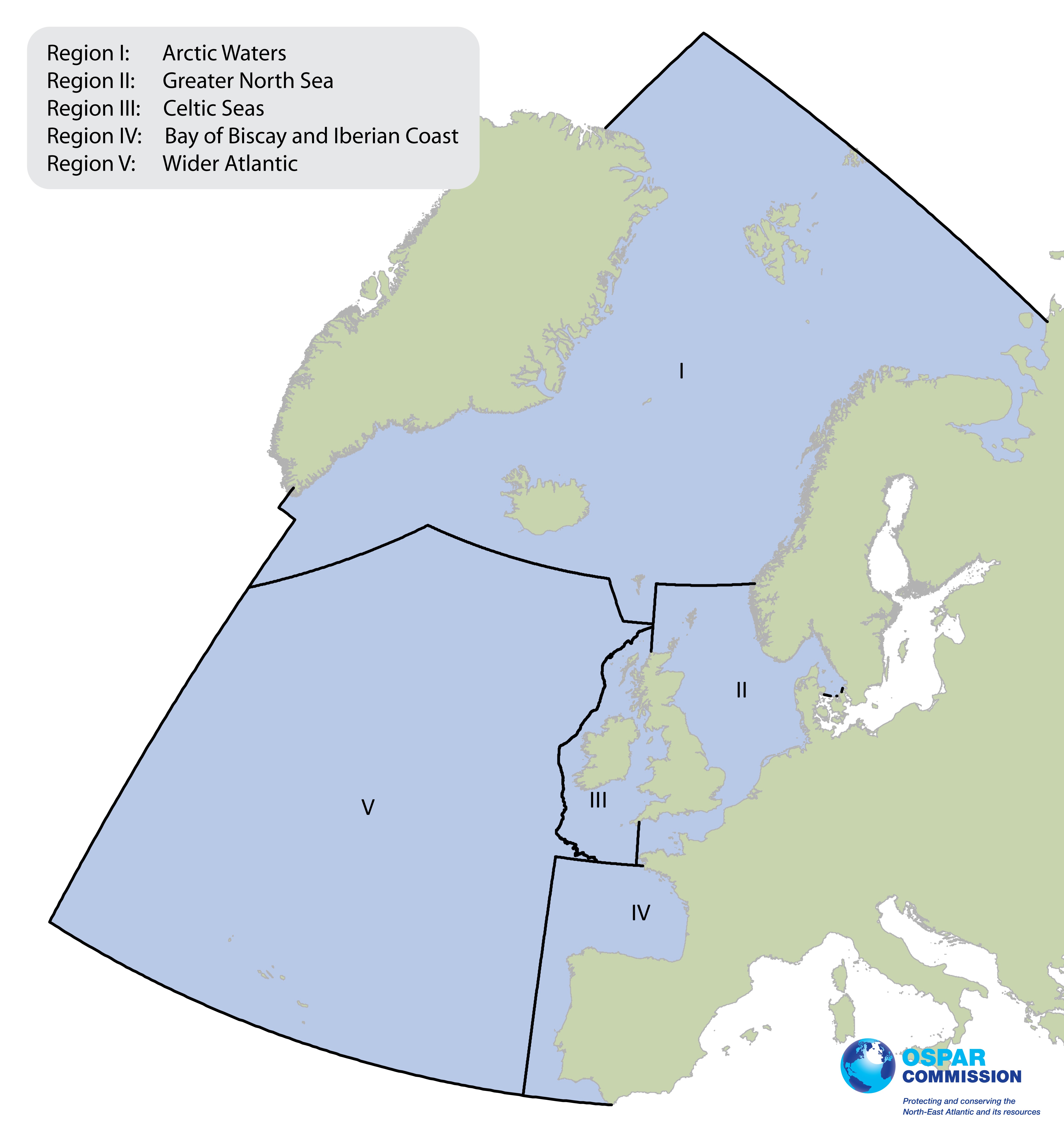
Figure 1.1 OSPAR Maritime Area and its Regions
The OSPAR Maritime Area covers most of the North-East Atlantic. It embraces open sea areas as well as inshore and coastal waters adjacent to densely populated catchments where pressures from human activities are particularly high. For assessment purposes, the OSPAR Maritime Area is divided into five Regions (Figure 1.1): Arctic (Region I), the Greater North Sea (Region II), the Celtic Seas (Region III), the Bay of Biscay and Iberian Coast (Region IV), and the Wider Atlantic (Region V).
Marine eutrophication is defined in the OSPAR Eutrophication Strategy as “the enrichment of water by nutrients causing an accelerated growth of algae and higher forms of plant life to produce an undesirable disturbance to the balance of organisms present in the water and to the quality of the water concerned, and therefore refers to the undesirable effects resulting from anthropogenic enrichment by nutrients as described in the Common Procedure”. This definition is similar to that adopted in European Community legislation relating to eutrophication. Primary production is often limited by the availability of light or nutrients. Nutrient enrichment may cause an increase in the growth of algae and higher forms of plant life but this depends on the availability of sufficient light and on the hydrodynamics of the water body. This in turn may lead to a range of undesirable disturbances in the marine ecosystem such as the oxygen depletion in bottom waters causing the death of fish and other species and significant shifts in the composition of the flora and fauna affecting habitats and biodiversity. A simplified schematic illustration of many of the issues associated with the eutrophication process is given in Figure 1.2.
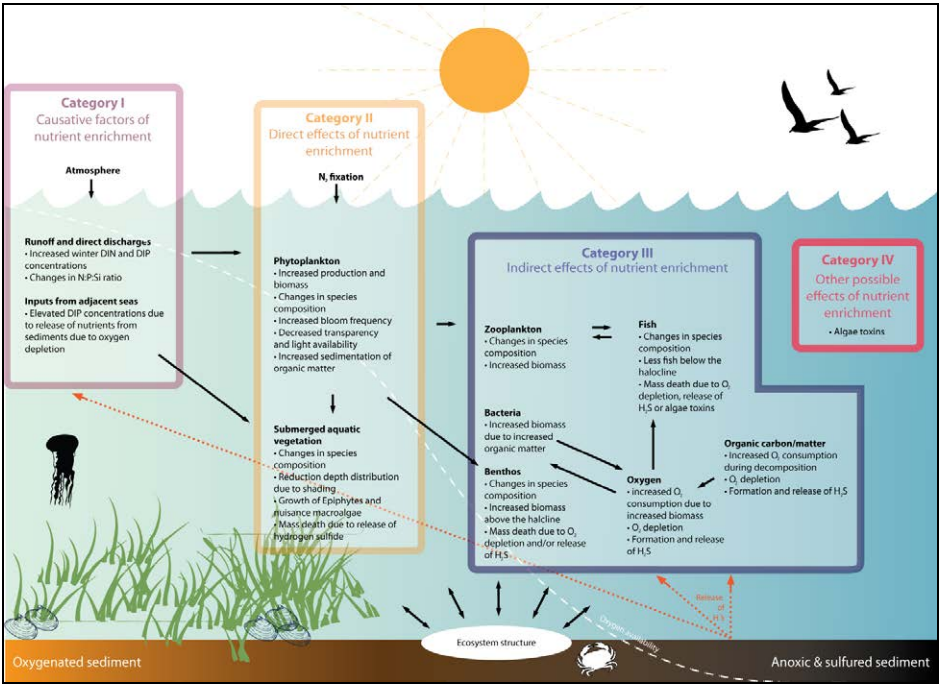
Figure 1.2: Simplified illustration of many of the issues associated with eutrophication.
DIN is dissolved inorganic nitrogen and DIP is dissolved inorganic phosphorus. N:P:Si is the ratio between nitrogen, phosphorus and silicate (after Ferreira et. al, 2010)
Human activities resulting in anthropogenic nutrient enrichment encompass inputs from point sources (e.g. sewage plants or industry) and from diffuse sources (e.g. agriculture, households not connected to sewerage, overflows, and atmospheric deposition). In combating human-induced eutrophication, the Eutrophication Strategy builds on long-standing work of OSPAR. This includes the commitment of Contracting Parties to achieve a substantial reduction at source, in the order of 50% compared to 1985, in inputs of phosphorus and nitrogen into areas where these inputs are likely, directly or indirectly, to cause pollution (PARCOM, 1998). These areas are defined as problem areas. To assist Contracting Parties in identifying these areas in a consistent way, OSPAR developed a common assessment framework: the Common Procedure for the Identification of the Eutrophication Status of the OSPAR Maritime Area (the “Common Procedure”). Under the Common Procedure waters are classified as problem areas, potential problem areas and non-problem areas with regard to eutrophication.
It is the responsibility of Contracting Parties to apply the Common Procedure to their parts of the OSPAR Maritime Area. The OSPAR Commission reviews the results of the national assessments. In cases in which the final classification results in problem areas with regard to eutrophication, the Eutrophication Strategy requires the OSPAR Commission and Contracting Parties, individually or jointly, to take measures to reduce or to eliminate the anthropogenic causes of eutrophication and to assess, based on implementation reporting, the effectiveness of those measures on the state of the marine ecosystem. In the case of potential problem areas with regard to eutrophication, preventive measures shall be taken in accordance with the precautionary principle and monitoring and research shall be urgently implemented to enable a full assessment of the eutrophication status of each area concerned after five years of its classification.
The Common Procedure is supported under the eutrophication-related part of the OSPAR Joint Assessment and Monitoring Programme (JAMP) (OSPAR, 2014a) by collective OSPAR monitoring. The Eutrophication Monitoring Programme (OSPAR, 2005) is supplemented by monitoring guidelines, as part of the OSPAR Coordinated Environmental Monitoring Programme (CEMP) (OSPAR, 2016). Monitoring and periodic assessments of temporal trends of waterborne and atmospheric inputs of nutrients to the OSPAR Maritime Area under the OSPAR Comprehensive Study of Riverine Inputs and Direct Discharges (RID) (OSPAR, 2014) and the OSPAR Comprehensive Atmospheric Monitoring Programme (CAMP) (OSPAR, 2015) also inform the assessment of the eutrophication status.
The implementation of the Eutrophication Strategy takes place within the framework of the obligations of Contracting Parties in this field in other fora. This includes, for example, the Urban Waste Water Treatment Directive (91/271/EEC) and the Nitrates Directive (91/676/EEC), which require Member States of the European Community and the European Economic Area to identify “sensitive areas” and nitrate “vulnerable zones”, respectively, as basis for the implementation of targeted measures to reduce nutrient inputs to these areas. Under the Water Framework Directive (2000/60/EC), an assessment framework closely linked to the conceptual approach of the Common Procedure has been set up to assess, classify and monitor the ecological quality of a water body in transitional and coastal waters. It requires the adoption of measures and programmes to achieve good ecological status of those waters. The Marine Strategy Framework Directive (2008/56/EC) requires EU Member States to take the necessary measures to achieve or maintain good environmental status in the marine environment by the year 2020 at the latest. This includes the goal to minimise human-induced eutrophication, especially adverse effects thereof, such as losses in biodiversity, ecosystem degradation, harmful algae blooms and oxygen deficiency in bottom waters.
OSPAR common indicators and the Intermediate Assessment 2017
OSPAR is developing a set of common indicators that will contribute to the Intermediate Assessment 2017 and may be used by Contracting Parties to support their assessment and reporting requirements under the EU Marine Strategy Framework Directive. In contrast to the Common Procedure assessments that are carried out by Contracting Parties for the waters under their jurisdiction, the common indicators are developed at regional scales. Eutrophication-related common indicators are being developed for nutrient inputs (both from rivers and the atmosphere), nutrient concentrations (in the sea), chlorophyll-a concentration (in the sea), Phaeocystis abundance (in the sea, in one part of the Maritime Area) and dissolved oxygen concentration (in waters near the seabed). The indicators focus on trends and contribute to assessing progress towards the objective of the Eutrophication Strategy. The common indicators may be used to support the assessment of progress towards the goal of the Marine Strategy Framework Directive as three indicators (nutrient concentrations, chlorophyll-a and dissolved oxygen) represent the primary criteria and one (Phaeocystis) represents a secondary criterion adopted in the 2017 revision of the European Commission Decision (EU, 2017).