

Status Assessment 2022 - Seamounts
| Assessment of status | Distribution | Extent | Condition | Previous OSPAR status assessment | Status (overall assessment) | |
|---|---|---|---|---|---|---|
Region | I | ←→1,2 | ←→1,2 | ↓3,5 | ● | poor |
| II | NA | |||||
| III | NA | |||||
| IV | ←→1,2 | ←→1,2 | ↓2,5 | ● | poor | |
| V | ←→1,2 | ←→1,2 | ↓2,4,5 | ● | poor | |
| Assessment of threats | Habitat damage | Removal of target/non-target species | Threat or impact | |
|---|---|---|---|---|
Region | I | ↓1 | ↓1 | ↓ |
| II | NA | |||
| III | NA | |||
| IV | ←→1,5 | ←→1,5 | ←→ | |
| V | ←→1,5 | ←→1,5 | ←→ | |
Explanation to table:
Distribution, Population size, Condition
Trends in status (since the assessment in the background document)
↓ decreasing trend or deterioration of the criterion assessed
↑ increasing trend or improvement in the criterion assessed
←→ no change observed in the criterion assessed
? trend unknown in the criterion assessed
Previous status assessment: If in QSR 2010 then enter Regions where species occurs ( ○) and has been recognised by OSPAR to be threatened and/or declining (● ) based on Chapter 10 Table 10.1 and Table 10.2 . If a more recent status assessment is available, then enter ‘poor’/’good’
Status*(overall assessment)
red – poor
green – good
? – status unknown
NA - Not Applicable
*applied to assessments of status of the feature or of a criterion, as defined by the assessment values used in the QSR 2023 or by expert judgement.
Key Pressure
↓ key pressures and human activities reducing
↑ key pressures and human activities increasing
←→ no change in key pressures and human activities
? Change in pressure and human activities uncertain
Threats or impacts (overall assessment)
red – significant threat or impact;
green–no evidence of a significant threat or impact
Blue cells – insufficient information available
NA – not applicable
1 – direct data driven
2 – indirect data driven
3 – third party assessment, close-geographic match
4 – third party assessment, partial-geographic match
5 – expert judgement
Confidence
Overall: Low confidence is placed on the assessment overall.
Distribution: High confidence that the distribution has not changed.
Condition: Low – medium confidence on the overall condition, based on data for some seamounts. Many seamounts have no data associated with them. The assessment on condition has been based on the seamount communities and not on the seamount feature itself.
Habitat Damage / Removal of target and non-target species: There is low confidence in the scale of fishing pressure currently implemented on the seamounts and therefore of the habitats being damaged and the removal of both target and non-target species. Available fishing data sets are not comprehensive, and analyses therefore rely on a series of assumptions.
Background Information
- Seamounts were added to the OSPAR list in 2003 with the habitat listed as threatened or declining in all Regions where they occur: I, IV, V: https://www.ospar.org/documents?v=7222
- Seamounts were placed on the OSPAR List because of the biological communities found on/in association with them as opposed to the seamount features themselves. Through trawling, commercial pelagic and benthic fish species are targeted, however suspension feeding fauna are also impacted from the physical impact.
- Seamounts were nominated in a joint submission by three Contracting Parties citing decline, sensitivity, and ecological significance, with information also provided on threat.
- Major threats were listed to be habitat damage and removal of target and non-target species, as listed in Table 10.3 of the OSPAR QSR 2010.
- In 2010, seamounts were assessed as particularly sensitive to human impacts, and that their associated biological communities were currently threatened.
Geographical Range and Distribution
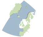
Seamounts are defined as topographic features that rise 1 000 m or more from the surrounding seafloor, but do not penetrate the sea surface. They are found extensively throughout Regions I and V with fewer located in IV (Figure 1), although it should be noted that area IV is notably smaller by comparison to those of Region I and V. In total, 100 distinct seamounts are found in the OSPAR Maritime Area (Kutti et al., 2019) based on the literature and bathymetric database. However, Harris et al. (2014) predicted that 161 seamounts would occur within the OSPAR Maritime Area and approximately 1 700 in the Atlantic region altogether. As more mapping is undertaken, the confidence in the number of seamounts in the OSPAR Regions will increase. Few seamounts in the three Regions where the seamounts are found have been extensively studied.
Seamounts, however, are not just associated with the OSPAR Maritime Area. They are found throughout the global oceans with estimates ranging between 10 000 to 30 000 (Yesson et al., 2011; Harris et al., 2014).
Method of assessment: 1b
, the GeoNames database and geomorphic features from Harris (2014)")
Figure 1: Distribution of seamounts in the OSPAR maritime area based on the OSPAR threatened and/or declining habitats database (points and polygons), the GeoNames database and geomorphic features from Harris (2014)
Extent
Seamounts in the OSPAR Maritime Area are not specifically monitored, however, they may be included in Spain and the United Kingdom’s monitoring of MPA regions (OSPAR 2014). Formigas and Castro Bank in the Azores region, and El Cachucho in Spanish waters are thought to be studied regularly and the results often provide information regarding the protection of these seamounts (Santos et al., 2010a,b). However, at present this is not a coordinated monitoring programme.
The physical extent of the habitat is not changing, however, the seamount communities are being impacted and their condition is declining.
Method of assessment: 3c
Condition
Overall habitat condition is considered to be declining in all Regions.
The presence and abundance of key species on seamounts and quality of abiotic components across the OSPAR Regions are not known, due to limited monitoring data. Due to data paucity, direct condition assessments are challenging. However, in the absence of in-situ measurements, condition could be inferred from the presence of pressure-causing activities (where pressure-receptor links are known).
Anton Dohrn, Rosemary Bank, and the Hebrides Terrace seamounts (all in Region V) as large-scale features, are not considered to be at significant risk and their condition is viewed as favourable (Brooks, 2013). However, the condition of the communities found on the Region V seamounts is deemed to be unfavourable as a result of both mobile- and static-gear commercial fishing activity (JNCC unpublished data).
Since implementation of management strategies in the mid-2000s, deep-water fisheries in the northern part of OSPAR Region V have reduced the excessive fishing pressure that this area was experiencing (Vieira et al., 2019).
 OSPAR regions I, IV & V combined; (B) OSPAR Region 1; (C) OSPAR Region IV and (D) OSPAR Region V.")
Figure 2: Proportion of seamounts in the OSPAR Marine Protected Area and/or NEAFC closure across, (A) OSPAR regions I, IV & V combined; (B) OSPAR Region 1; (C) OSPAR Region IV and (D) OSPAR Region V.
A proportion of seamounts exist within Marine Protected Areas and/or NEAFC closures in all OSPAR regions, however only in Region V do the seamounts fall within both an MPA and NEAFC closure (Figure 2).
Method of assessment:
2. Assessment derived from third party assessment
b) based mainly on expert opinion with very limited data
Threats and Impacts
Key pressures to seamounts in the QSR 2010 were habitat damage and removal of target and non-target species. Additional threats included hunting, harvesting, bioprospecting and extraction of mineral resources.
Seamount communities are very sensitive to the impacts from trawling and commercial fisheries, and these continue to be a threat to seamount habitats, with fisheries activities occurring across all OSPAR Regions. Deep-water fisheries have expanded since the 1960s (Vieira et al., 2019) and are a continued threat to commercial deep-water fish species through overexploitation (Menezes et al., 2013). Deep water fish are especially vulnerable to overexploitation due to their typical life history of slow growing, late reproducing species. Bottom trawling also abrades the seafloor and its biological assemblages, increases sediment resuspension, and results in removal of non-target species as by-catch (Clark et al., 2016).
In OSPAR Region V, impacts of fishing activity to seamounts in the Azores have been recorded (Menezes et al., 2013; Santos et al., 2021) and fishing is known to occur across UK seamounts such as the Hebrides Terrace and Anton Dohrn (ICES, 2006). Fishing activity is also prominent in Region IV across seamounts such as Gorringe Bank (Vieira et al., 2015) (Figure 3). A small number of seamounts in Region I around the Mid Atlantic Ridge are also considered commercially important for fisheries, however, fishing activity on the Mid Atlantic Ridge has declined since 2010 (ICES, 2020).
There are other less significant current and future threats.
 Relative change in fishing pressure in the OSPAR Region after introduction of EU regulation 2016/2236 with seamounts overlaid, and change in fishing pressure in cells known to contain seamounts for b) OSPAR Region I, c) OSPAR Region IV and (D) OSPAR Region V.")
Figure 3: a) Relative change in fishing pressure in the OSPAR Region after introduction of EU regulation 2016/2236 with seamounts overlaid, and change in fishing pressure in cells known to contain seamounts for b) OSPAR Region I, c) OSPAR Region IV and (D) OSPAR Region V.
Measures that address key pressures from human activities or conserve the species/habitat
3.1a France has introduced legislation to protect habitats including Seamounts in the OSPAR area, whilst Norway has partially implemented the legislation and Iceland are considering it. In the United Kingdom, seamounts are also protected under “The Conservation of Habitats and Species Regulations 2017”.
3.1b Spain has already protected Le Danois seamount through the El Cachucho SAC. EU regulation 2016/2336 also implements a ban on bottom trawling below 800 m in EU waters of the NE Atlantic which includes areas on seamounts.
3.1c Spain is currently revising and updating its management plan for the El Cachucho SAC which will determine whether current measures are suitable or if further measures are needed to address key threats. Iceland has no direct management plans in place as it is felt that the seamounts are not being impacted by fisheries or other human activity.
3.1d France, Norway and Spain all have various programmes running either monitoring seamounts (Spain) or mapping VMEs (France/Norway). The most recent surveys undertaken by the United Kingdom were on Rosemary Bank (2016/2018) and Anton Dohrn (2018). Iceland has not surveyed their seamount habitats because of lack of infrastructure and cost associated with this work.
3.1e Increasing the knowledge of the occurrence and threats to seamounts is being looked at by Norway and Spain through their current/to be revised management plans for marine areas. The knowledge base of seamounts in Icelandic waters will be undertaken by individual research programmes.
3.1f Iceland has indicated that there are potentially vulnerable habitats/species on their seamounts but they have yet to be explored, whilst Le Danois seamount (Bay of Biscay, Region IV) has been designated as a SAC and is also part of the OSPAR MPA Network (Figure 4).
3.1g Spain has implemented conservation measures for the El Cachucho SAC that looks to minimise impacts on the protected seamounts. VMEs are covered by general regulations implemented for deep-sea fishing and human activities in Norway. The United Kingdom published all the site conservation and advice on operations documents for UK MPAs in 2018.
3.1h Iceland, Norway and Spain are raising awareness of seamounts through current research, management plans, and specific projects that have had workshops, e.g., the general public.
3.1i Spain is already working with the relevant competent authorities to fulfill this recommendation. Iceland has looked into this, however, there is no human pressure on the seamounts in their EEZ, whilst Norway is aggregating the knowledge around this.
NEAFC closures to bottom-contacting fishing gear are in place for 2 seamounts: Altair and Antialtair in Region V.
Within EU waters, Regulation (EU) 2016/2336 restricts bottom fishing >400 m to the 2009-2011 fishing footprint, prohibits bottom fishing >400 m where VMEs are known or likely to occur (through designation of VME closures) and places a complete ban on bottom trawling deeper than 800 m. Within UK waters, regulation (EU) 2016/2336 is transposed into the Common Fisheries Policy and Aquaculture (Amendment etc.) (EU Exit) Regulations 2019, with the same fishing restrictions and prohibitions in place. In Norwegian waters, Regulation 2011/755 restricts fishing with bottom contacting gear on vulnerable benthic habitats in areas deeper than 1 000 m (or 800 m) applies in the Norwegian Economic Zone, including the Fisheries Protection Zone near Svalbard and in the Fisheries Zone around Jan Mayen.

Figure 4: Distribution of seamount records with respect to MPA and Fisheries closures within the OSPAR Area.
Conclusion (including management considerations)
There has been an increase in research expeditions surveying seamounts and their biological communities, which has increased our overall knowledge. The distribution and extent of seamounts has not changed; however, the condition of the seamount communities is considered to be declining based on the impact of on-going fishing pressure targeting specific seamounts, particularly in Regions VI and V. While fishing pressure has reduced in some parts of the OSPAR Maritime area as a result of new legislation, there remain extensive numbers of seamounts outside areas protected by some form of legislation. The confidence in our assessment of the fishing pressure is low.
MPAs protect some of the biological communities found on the seamounts in the OSPAR Regions, but not all MPAs have management plans.
Additional survey work would be beneficial to ground truth the modelled seamount distribution maps. Some of the seamounts are unlikely to be currently targeted by deep-sea fisheries, particularly those with summits deeper than 1 500 m. Other pressures such as climate change and mining may still present a threat to the biological communities and the underlying seamount itself.
Given the slow growth rate of biological communities found in association with seamounts, reassessment of recovery / improvement could be on a longer time-scale (e.g., 5 to 10 years) in order to detect any changes and assess the effectiveness of management measures. Detection of damage or deterioration from e.g., fishing may require a more frequent assessment cycle to ensure timely intervention.
Knowledge Gaps
Seamounts in the OSPAR Regions are not regularly monitored and any information about them is collected from research cruises (e.g., Davies et al., 2015; McIntyre et al. 2016), as well as mining of historical data (e.g., Vieira et al. 2019). This lack of regular monitoring makes it increasingly difficult to determine what changes are taking place and whether changes are a result of natural variability or anthropogenic impact. Repeat monitoring of seamounts would better inform future prospects of this habitat.
In addition, there are numerous seamounts that have not been mapped or investigated in any detail. Doing so would provide much needed baseline information.
Method used
Assessed as part of a group of deep-sea habitat assessments led by Ireland, chaired by Louise Allcock (National University of Ireland Galway, Ireland). Seamount habitat assessment by Bhavani Narayanaswamy (Scottish Association of Marine Science, United Kingdom; habitat lead), Brian Bett (National Oceanography Centre, United Kingdom), Laura Robson (Joint Nature Conservation Committee, United Kingdom), David Stirling (Marine Scotland Science, United Kingdom), Liam Matear (Joint Nature Conservation Committee, United Kingdom), David Lyons (National Parks and Wildlife Service, Ireland), Kerry Howell (University of Plymouth, United Kingdom), Louise Allcock (NUI Galway, Ireland), with further contributions from the participants of the OSPAR deep-sea habitat assessment workshop, held online 6 to 8 September 2021. GIS analyses by Oisín Callery (NUI Galway, Ireland) and Anthony Grehan (NUI Galway, Ireland).
Brooks AJ. (2013) Assessing the sensitivity of geodiversity features in Scotland’s seas to pressures associated with human activities. Scottish Natural Heritage Commissioned Report No 590.
Davies JS, Stewart HA, Narayanaswamy BE, Jacobs C, Spicer J, Golding N & Howell KL. (2015) Benthic Assemblages of the Anton Dohrn Seamount (NE Atlantic): Defining Deep-Sea Biotopes to Support Habitat Mapping and Management Efforts with a Focus on Vulnerable Marine Ecosystems. PLoS ONE 10(5): e0124815. doi:10.1371/journal.pone.0124815
Harris PT, Macmillan-Lawler M, Rupp J, Baker EK. (2014) Geomorphology of the oceans. Marine Geology, 352, 4-24. doi: 10.1016/j.margeo.2014.01.011
ICES (2006) Report of the Working Group on the Biology and Assessment of Deep-sea Fisheries Resources (WGDEEP), 2–11 May 2006, ICES HQ, Copenhagen, Denmark. ICES CM 2016/ACFM:28, p. 504.
ICES (2016) Report of the Working Group on Biology and Assessment of Deep-sea Fisheries Resources (WGDEEP), 20–27 April 2016, ICES HQ, Copenhagen, Denmark. ICES CM 2016/ACOM:18, p. 648.
ICES (2020) Working Group on the Biology and Assessment of Deep-sea Fisheries Resources (WGDEEP). ICES Scientific Reports. 2:38. p 928.
McIntyre FD, Drewery J, Eerkes‐Medrano D, Neat FC. (2016) Distribution and diversity of deep‐sea sponge grounds on the Rosemary Bank Seamount, NE Atlantic. Marine Biology, 163:143 DOI 10.1007/s00227-016-2913-z
Menezes GM, Diogo H, Giacomello E. (2013) Reconstruction of demersal fisheries history on the Condor seamount, Azores archipelago (Northeast Atlantic). Deep Sea Research I, 98: 190-203
OSPAR (2014) OSPAR threaetened and/or declining species and habitats implementation report. Habitat: Seamounts. OSPAR recommendation 2014/09. https://www.ospar.org/site/assets/files/44271/seamounts_reporting.pdf
Santos R, Medeiros-Leal W, Novoa-Pabon A, Silva H, Pinho M. (2021) Demersal fish assemblages on seamounts exploited by fishing in the Azores (NE Atlantic). Journal of Applied Ichthyology, 37(2): 198-215
Santos RS, Tempera F, Menezes G, Porteiro F, Morato T. (2010a) Mountains in the Sea: Sedlo Seamount, Azores. Oceanography, 23 (1): 148-149
Santos RS, Tempera F, Colaço A, Cardigos F, Morato T. (2010b). Mountains in the Sea: Dom João de Castro Seamount, Azores. Oceanography, 23 (1): 146-147.
Vieira RP, Trueman CN, Readdy L, Kenny A, Pinnegar JK. (2019) Deep-water fisheries along the British Isles continental slopes: status, ecosystem effects and future perspectives. J. Fish Biol. 94, 981–992. doi: 10.1111/jfb.13927
Vieira RP, Raposo IP, Sobral P, dos Santos Gonçalves JM, Bell KLC, Cunha MR. (2015) Lost Fishing Gear and Litter at Gorringe Bank (NE Atlantic). Journal of Sea Research, 100:91-98 10.1016/j.seares.2014.10.005
Yesson C, Clark MR, Taylor ML, Rogers AD. (2011) The global distribution of seamounts based on 30 arc seconds bathymetry data. Deep Sea Research I, 58(4): 442-453
Sheet reference:
BDC2022/seamounts