

Proportion of Large Fish (Large Fish Index)
D4 - Marine Food Webs
D1.7 - Ecosystem Structure
Recovery in the proportion of large fish in the demersal fish community is evident in the Greater North Sea. Assessment values indicating recovery are only met in the northern part of the Celtic Seas. In many individual survey-based assessments where assessment values are not currently met, recent recovery trends suggest they could be achieved by 2022, if current pressure levels are not increased.
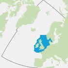
Area Assessed
Printable Summary
Background
Fishing mortality constrains the age structure of fish communities, reducing the proportion of larger / older individuals. Fishing is also size-selective, preferentially removing larger / older fish, and therefore affects fish community size composition. So far, three indicators relating to fish size have been developed to assess impacts of fishing on fish communities and the food web, considering parameters showing different responses in the ecosystem.
The Large Fish Index (LFI) has been developed to respond to fishing pressure on the proportion of large fish in demersal fish communities (species living on or near the seafloor). It was developed to support the Ecological Quality Objective for the North Sea demersal fish community. The North Sea LFI methodology has subsequently been adapted to derive LFIs for the Celtic Sea and Northern Iberian Shelf Sea.
The LFI uses estimates of fish abundance-at-length provided by international bottom trawl surveys. These are standardised monitoring programmes that occur each year in the same period taking representative samples according to specific guidelines. The assessment of each survey involves determining the suite of species constituting the demersal fish community and the length criteria defining large fish. The proportion of the demersal fish biomass that has a length exceeding the length criteria can then be calculated.
Specific assessment values are derived from the time series used for each regional assessment. The longest survey time series analysed started in 1983.
The Large Fish Index (LFI) was developed for the North Sea (Greenstreet et al., 2011, 2012), and uses estimates of fish biomass density-at-length provided by the first quarter (Q1) international bottom trawl survey. First, the suite of species constituting the ‘demersal fish community’ was established. Second, the length value (LLF) defining ‘large fish’ was determined. The LFI could then be derived as:
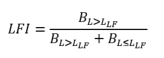
where L is length (in cm) and B is biomass density (as kg/km2).
The methodology to derive the LFI for the North Sea has subsequently been adapted to derive LFIs for the Celtic Sea (Shephard et al., 2011) and the Northern Iberian coastal shelf (Modica et al., 2014). For example, in the initial North Sea study, LLF=40cm, whereas in the Celtic Sea and Northern Iberian coast, LLF =50cm and LLF =35cm respectively. To establish assessment values, these studies have either used actual LFI values observed at a time when the LFI had yet to be adversely impacted by fishing, or they have used the observed relationship between the LFI and fishing mortality to estimate LFI values consistent with sustainable mortality across a suite of species. In the North Sea and Celtic Sea studies the former approach suggested LFI targets of LFI=0.3 and LFI=0.4 respectively, whereas in the Northern Iberian coast the latter approach inferred a target of LFI=0.35. Thus, rather than applying a prescribed LFI definition to other areas and data-sets, a prescribed methodology has instead been used to derive area- or data-specific LFIs for each new situation.
In all three studies, the relationship between variation in fishing mortality and the LFI response was time-lagged, with the LFI response following as much as 16 years after changes in fishing mortality. Modelling studies have since confirmed that recovery of demersal fish community size composition was likely to occur only over decadal time scales (Fung et al., 2013; Shephard et al., 2013; Spiers et al., 2016). In the three studies where the LFI protocol has been established, these time-lagged responses suggest that the necessary fisheries management measures required for the LFI to reach the assessment values stipulated for each community have already been implemented, and that these assessment values should be achieved within ten years with no further management action necessary. However, a subsequent study has suggested that recovery of the LFI in the North Sea may have faltered (Fung et al., 2012).
In the Quality Status Report (QSR) 2010, the assessment of the Greater North Sea Ecological Quality Objective (EcoQO) on the proportion of large fish showed that from the early 1980s, the percentage of fish greater than 40 cm declined from around 30% to a low of less than 5% in 2001. By 2008, it has recovered to around 22% but the need to make further progress to reach the level of the EcoQO (30%) was recognised.
Indicator Metric and Data Collection
In order to assess the state of demersal fish size composition, the Large Fish Index (LFI) time series were determined for 13 groundfish surveys carried out across two separate regions: the Greater North Sea and the Celtic Seas. Between six and seven LFI time series were derived for each region (Table a).
Table a. Groundfish surveys, region in which they operate, and the period over which they have been undertaken
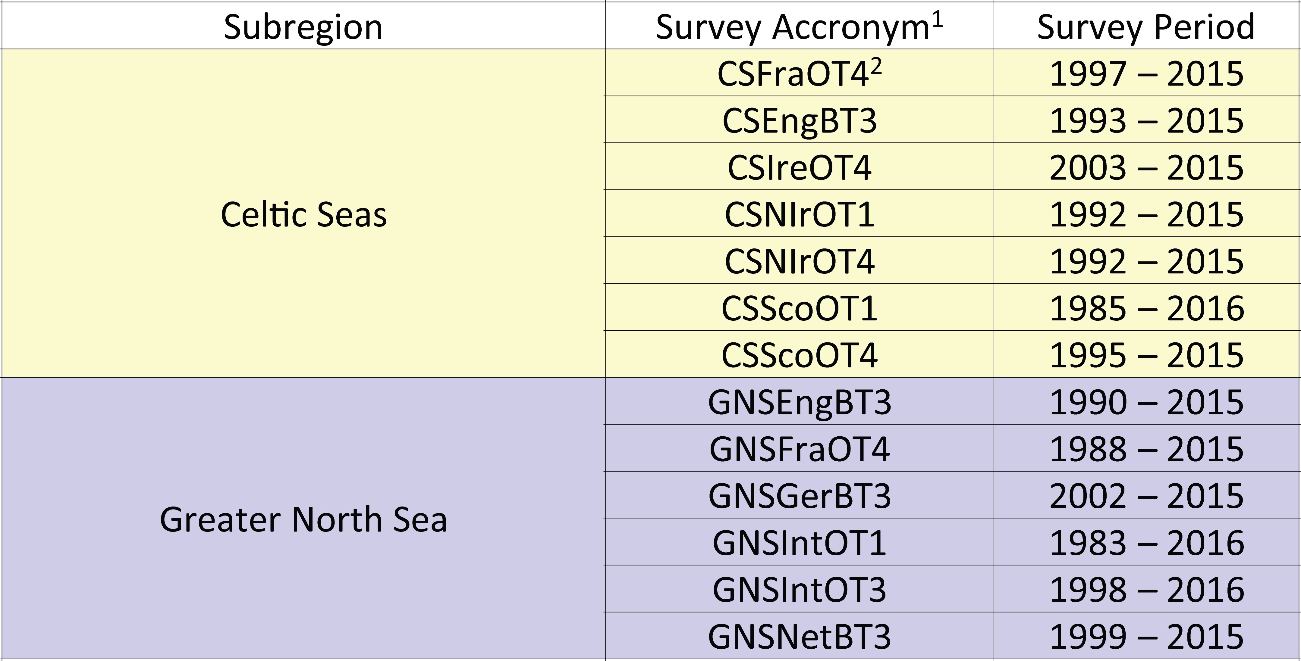
1. Survey acronym convention: First two to four capitalised letters indicate the European Union (EU) Marine Strategy Framework Directive (MSFD) region (CS: Celtic Seas; GNS: Greater North Sea;). Next capitalised and lowercase letters signify the country involved (Fra: France; Eng: England; Ire: Republic of Ireland; NIr: Northern Ireland; Sco: Scotland; Ger: Germany; Int: International; Net: The Netherlands). International refers to the two international bottom trawl surveys carried out in the North Sea under the auspices of the International Council for the Exploration of the Sea (ICES). Next two capitalised letters indicate the type of survey (OT: otter trawl; BT: beam trawl). Final number indicates the season in which the survey is primarily undertaken (1: January to March; 3: July to September; 4: October to December).
2. This is a single survey that operates in the Celtic Seas and the Bay of Biscay and Iberian Coast regions, from the southern coast of the Republic of Ireland and down the western Atlantic coast of France. For Large Fish Index (LFI) assessment purposes this single survey was split into its two regional components.
Standard data collected on these surveys comprise numbers of each species of fish sampled in each trawl sample, measured to defined length categories (i.e. 1 cm below, so a fish with a recorded length of 14 cm would be between 14.00 cm and 14.99 cm in length). By dividing these species catch numbers-at-length by the area swept by the trawl on each sampling occasion, the catch data are converted to standardised estimates of fish density-at-length, by species, at each sampling location. Summing these trawl-sample species density-at-length estimates across all trawl samples collected within each sampling stratum in each year (e.g. ICES statistical rectangles), and dividing by the number of trawl samples within each stratum per year, gives estimates of the density (of each species and length category) within each sampling stratum in each year. Summing these sample stratum density estimates across all sampling strata sampled in each year, and dividing by the number of strata sampled, provides estimates of the average density (N), of each species (s) and length category (l), in each year, across the whole area covered by the survey. It is these last density estimates (Ns,l km2) that are used in the calculation of each survey LFI time series. However, the LFI is based on biomass rather than abundance, so these abundance densities have to be converted to biomass density data by applying species weight-at-length relationships (of the form w = alb, where w is weight and a and b are species-specific parameters).
Deciding on the species to be included in the analysis is the first step in calculating each survey LFI time series. The FishBase website (www.fishbase.org) provided an ‘ecotype’ classification for all species encountered. The LFI has been designed as an indicator of size composition within demersal fish communities, so species assigned to the Pelagic and Bathypelagic ecotypes were automatically excluded, while species assigned to the Demersal and Bathydemersal ecotypes were automatically included. Species belonging to the Benthopelagic ecotype were generally included, but with the exceptions of Clupea harengus, Dysomma brivirostre, Hyperoplys immaculatus, Ammodytidae (family-level ID code), Salmo (genus-level ID code), Salmo salar and Sarpa salpa, which were all excluded on the basis that these species are relatively poorly sampled by the survey gear.
Determining the appropriate length value (LLF) that defined ‘large fish’ for each survey had next to be determined. Traditionally this has been achieved by fitting 5th degree polynomial functions to LFI time series derived using a range of LLF lengths, from 20 to 50 cm, where the LFILLF=l is calculated as:
and selecting the LFI time series with the best fit. In five instances the LFI time series with the best fit polynomial was not selected to support the assessment because resultant LFI values were either too high, or too low, so that either too great a fraction, or too small a fraction of fish were classified as ‘large fish’. Where this happened the actual signal in the LFI trend was markedly diminished, and an alternative LFI time series that addressed this issue was used instead (Table b). The proportion of total biomass at LLF > 50 cm becomes too small to derive a usable indicator; resulting indicators are too strongly influenced by the ‘noise’ associated with variation in the biomass of fish <50 cm in length.
Table b. Length value (LLF) defining ‘large fish’ for each survey
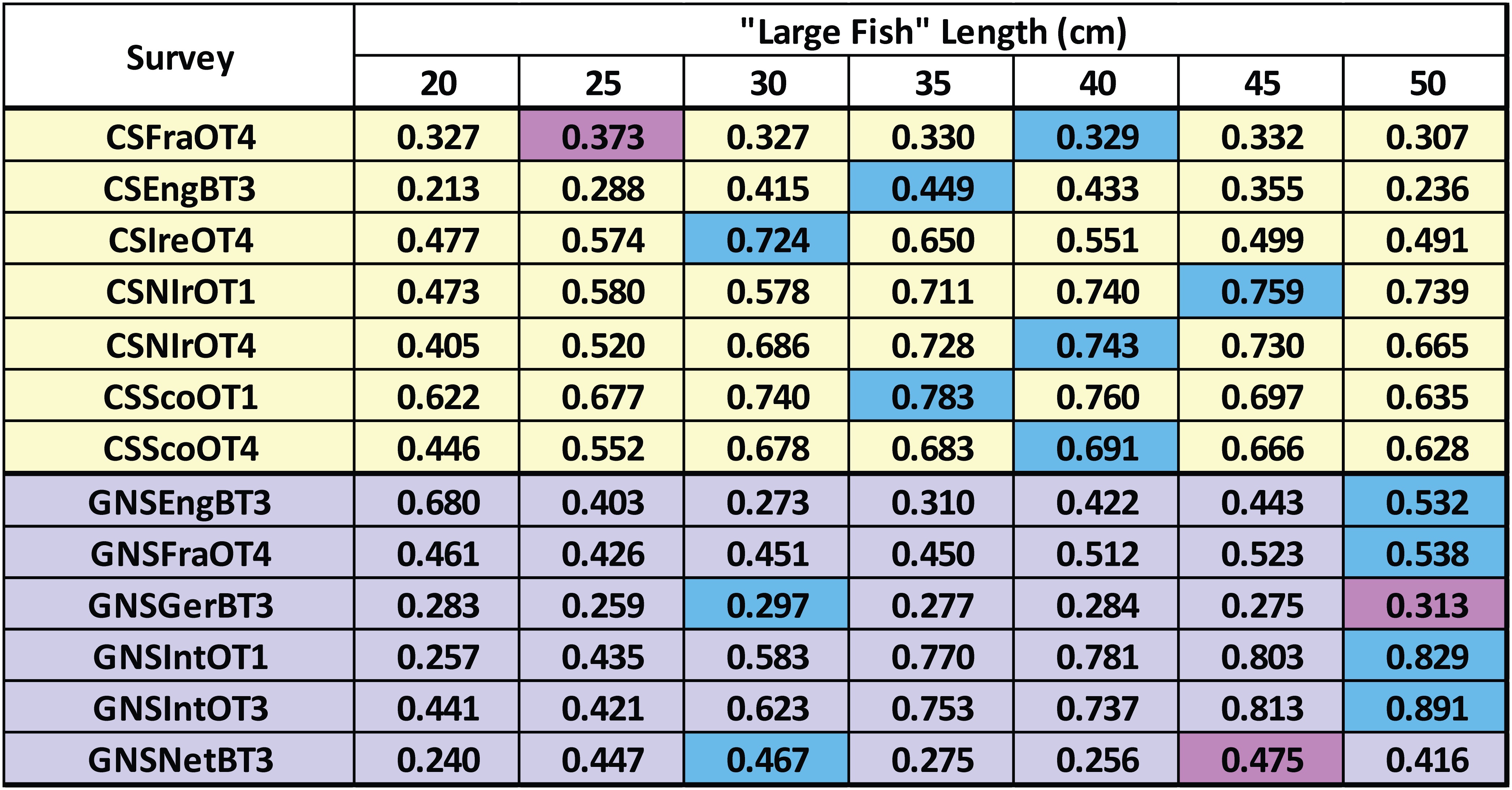
The table shows regression (R2) values for 5th degree polynomial fits to each Large Fish Index (LFI) time series. Blue cells show the best fit for each survey. Dark Purple cells show the LFI time series selected to support assessment where this was not the best 5th degree polynomial fit.
Spatial Scope: Assessment Units
A single LFI time series was selected for each survey and individual survey-based assessments were performed. The individual survey-based assessments within each region were then considered to determine an overall assessment outcome for each region.
Baselines
The published study in the Greater North Sea (Greenstreet et al., 2011) established the early 1980s as the reference period for setting the OSPAR Ecological Quality Objective (EcoQO) for the North Sea first quarter (Q1) international bottom trawl survey (IBTS) LFI. This period was selected on the basis that this was the last time that ICES advice for setting fish quotas was to maintain status quo; i.e. to carry on fishing at prevailing levels because stocks were not considered to be unduly depleted (Greenstreet et al., 2011). Selection of this reference period led to the adoption of an LFI of >0.3 as the EcoQO for the North Sea (Heslenfeld and Enserink, 2008). In the Celtic Sea study, Shephard et al. (2011) noted a period of relatively stable LFI values during the late 1980s and early 1990s, which included the six highest LFI values recorded. The stability of the LFI, combined with these high values, led Shephard et al. (2011) to adopt this period as their reference period, and consequently to suggest an LFI of >0.4 as a possible EcoQO for the Celtic Sea.
Assessment Values
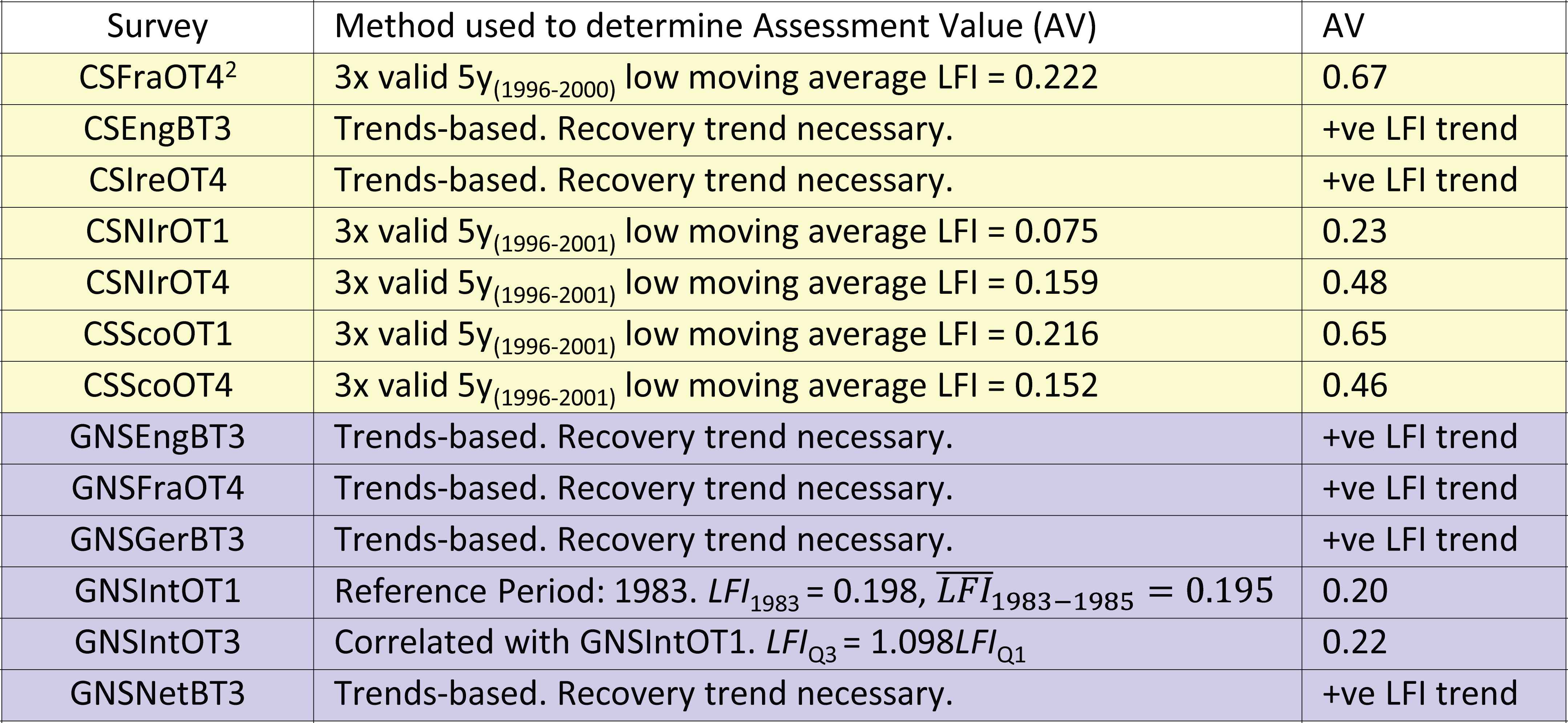
Where feasible, studies discussed in the previous (Baselines) section were drawn on to set assessment values for as many of the 13 groundfish survey LFI time series as possible. A number of approaches for doing this were applied.
Greater North Sea
In the Greater North Sea, the principle surveys used to support assessment were the GNSIntOT1 and GNSIntOT3 surveys. GNSIntOT1 is the same survey analysed by Greenstreet et al. (2011), so the same reference period of the early 1980s was used. The GNSIntOT1 and GNSIntOT3 surveys were strongly correlated, so the linear regression obtained was used to determine an assessment value for GNSIntOT3 that was equivalent to the assessment value for GNSIntOT1. Absolute assessment values could not be set for the remaining four Greater North Sea surveys, so a recovery trends-based approach was adopted.
Celtic Seas
In the Celtic Seas, the United Kingdom west coast groundfish survey (WCGFS) analysed by Shephard et al. (2011) ceased in 2004 and so was no longer available for assessment purposes. However, this analysis could be used to inform assessment value setting for the current surveys. The lowest LFI values reported by Shephard et al. (2011) during the reference period was 0.42, so this was adopted as the assessment value rather than their suggested value of 0.40. Generally, low values were observed between 1994 and 2004, and within this period, the lowest five year moving average LFI (0.138) was observed between 2000 and 2004. The assessment value of 0.42 was three times this lowest five year moving average value. So the procedure for setting assessment values for on-going otter trawl surveys in the Celtic Seas region was as follows:
- Determine the lowest five year moving average LFI value;
- Identify the period to which this five year low moving average LFI relates. If between 1994 and 2004, then this was deemed a valid five year low LFI;
- The assessment value was then set at three times the five year low moving average LFI value.
Summary of Assessment Value Approaches
Where the setting of absolute assessment values was not feasible, a trends-based approach was adopted assuming that the demersal fish community in question had been impacted by fishing and that a recovery trend (increasing LFI values) was therefore necessary to rectify the harm done. Table c summarises the assessment value setting approach used and the resulting assessment values.
Table c. Approaches to setting assessment values (AV) applied to each survey
Results
Trends in the Large Fish Index (LFI) in each of the 13 groundfish surveys assessed are shown in Figure 1.
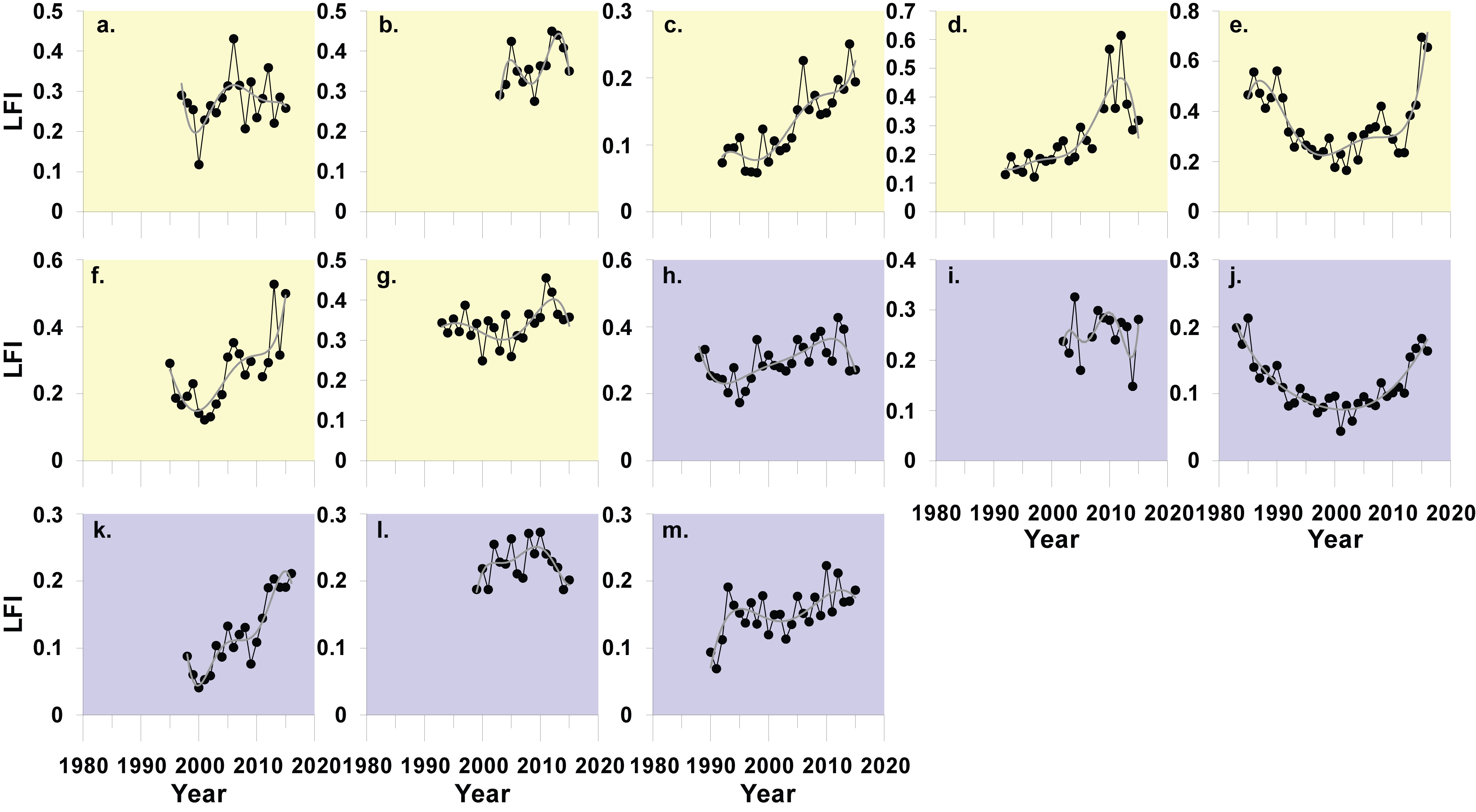
Figure 1: Trends in the large fish index (LFI) in 13 groundfish surveys in the Greater North Sea and Celtic Seas using the optimal length value (LLF) determined to define ‘large fish’ for each survey
Plots are colour coded to reflect region (yellow: Celtic Seas; purple: Greater North Sea)
The assessment in the Greater North Sea relied primarily on two surveys (Figure 1 - plots j and k), conducted at different times of the year, which both covered the greater part of the Region. Both surveys suggest that the proportion of large fish does not currently meet assessment values (Figure 2 and Figure 3). However, both surveys show recovery and that size composition has recovered strongly from its most disturbed condition at the turn of the century. Extrapolation of current recovery trends in these two surveys suggests that LFI assessment values should be met before the next European Union (EU) Marine Strategy Framework Directive (MSFD) assessment in 2024. These results are generally supported by the other surveys.
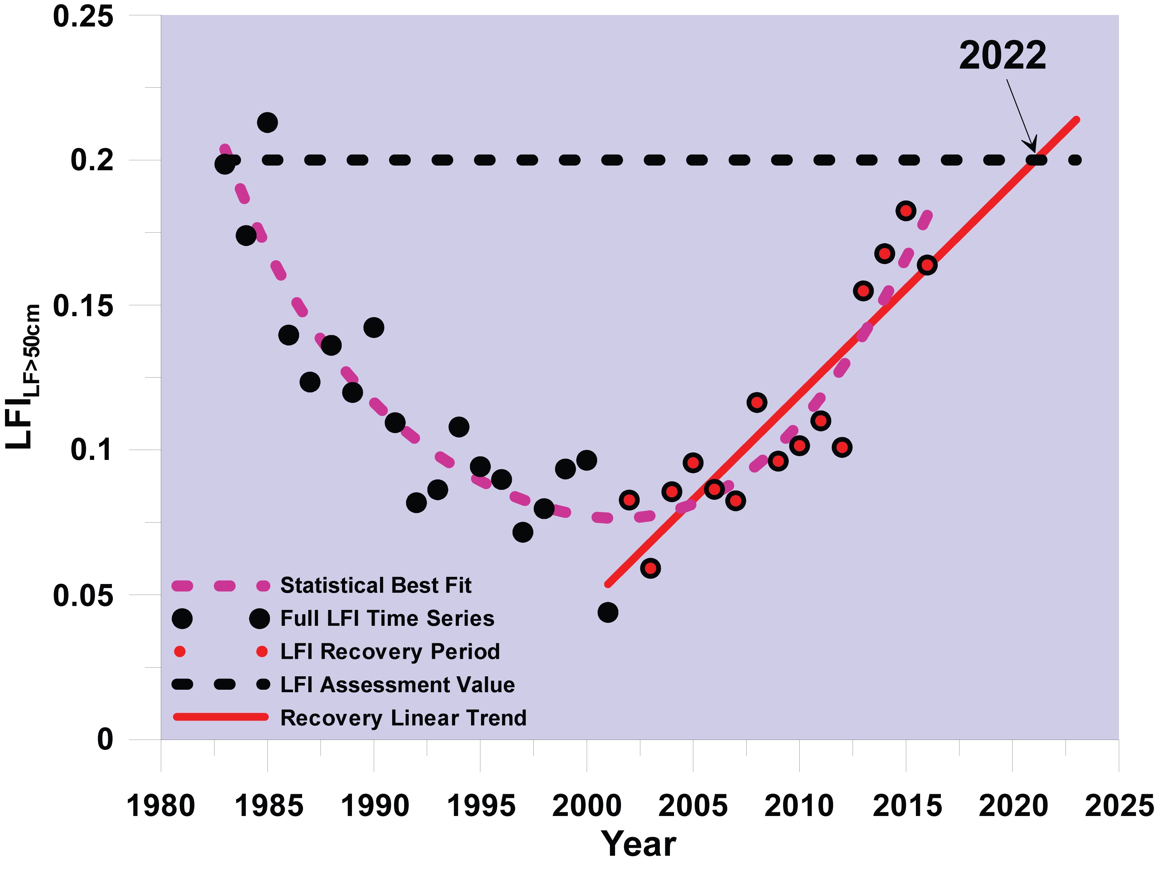
Figure 2: Large Fish Index (LFI) time series for the first quarter
The LFI time series is derived from the first quarter (January to March) international otter trawl survey in the Greater North Sea (Figure 1, plot j)showing annual data, data used to determine the recovery trend, linear trend fitted to the recovery period data, and the LFI assessment value.
Figure 3: Large Fish Index (LFI) time series for the third quarter
The LFI time series is derived from the third quarter (July to September) international otter trawl survey in the Greater North Sea (Figure 1, Plot k) showing annual data used to determine the recovery trend, linear trend fitted to the recovery period data, and the LFI assessment value.
Surveys in the Celtic Seas only covered relatively small parts of that region. The assessment therefore relied on the compilation of individual survey-based assessment outcomes. The proportion of large demersal fish meets the assessment value in the northern half of the region (Figure 1 - plots e and f). The LFI in other parts of the Celtic Seas region does not meet the assessment value. Recovery is evident in the Irish Sea and LFI assessment values could be achieved there by 2020 (Figure 1 - plots c and d). In the south and west of this region, evidence of a recovery in LFI values is unclear (Figure 1 - plots a, b and f), and at best suggests that it could take a decade or more before the assessment value is reached, unless current levels of pressure are reduced.
There is medium / high confidence in the assessment methodology and high confidence in the data availability.
Assessment Outcome Summary
All 13 individual groundfish survey Large Fish Index (LFI) trends are shown in Figure a.
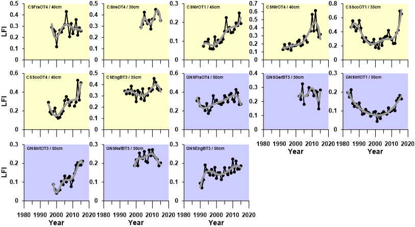
Figure a. Large Fish Index (LFI) trends for the 13 groundfish surveys derived using the optimal length (LLF) value determined for each survey
Plots are colour coded to reflect region (yellow: Celtic Seas; purple: Greater North Sea)
Greater North Sea summary
The assessment was principally dependent on two otter trawl surveys (GNSIntOT1, GNSIntOT3), but was generally supported by the other surveys. Size composition in the demersal fish community of the Greater North Sea is currently below assessment values. However, strong recovery trends are evident and extrapolation of these trends suggests assessment values could be met by 2022. Time lags in the LFI response to changing fishing pressure could infer that the necessary measures have already been implemented.
Celtic Seas summary
Size composition in the demersal fish community of the Celtic Seas is currently at acceptable status in the north of the region, and showing strong recovery in the east, potentially enough to meet LFI assessment values by 2019. In the south and west, assessment values are not met and evidence for recovery is not convincing, and at best it is likely to require a decade or more before assessment values are achieved. Further restriction of fishing activity may be necessary in the south and west, and elsewhere there is little scope for any expansion in activity levels.
The following sections summarise details for the individual survey assessments by region.
Greater North Sea assessment
GNSIntOT1 Survey
- LLF = 50 cm;
- 1983 LFI>50cm value is 0.1986 and average LFI>50cm value over the period 1983–1985 is 0.1951;
- Assessment value is therefore 0.2;
- 2016 LFI>50cm value is 0.164 and average LFI>50cm value over the period 2014–2016 is 0.171;
- The Greater North Sea LFI is currently below its assessment value;
- LFI>50cm low point (0.044) occurred in 2001;
- Strong recovery from 2002 onwards with LFI>50cm increasing annually by 0.073 on average;
- Linear trend fitted to recovery period suggests the 0.2 assessment value should be met by 2020 (Figure b);
- Residuals from this trend in the last three years of the time series are all positive suggesting a HIGH level of confidence that the assessment value will be achieved by 2024; and
- This conclusion is consistent with the predictions of Greenstreet et al. (2011).
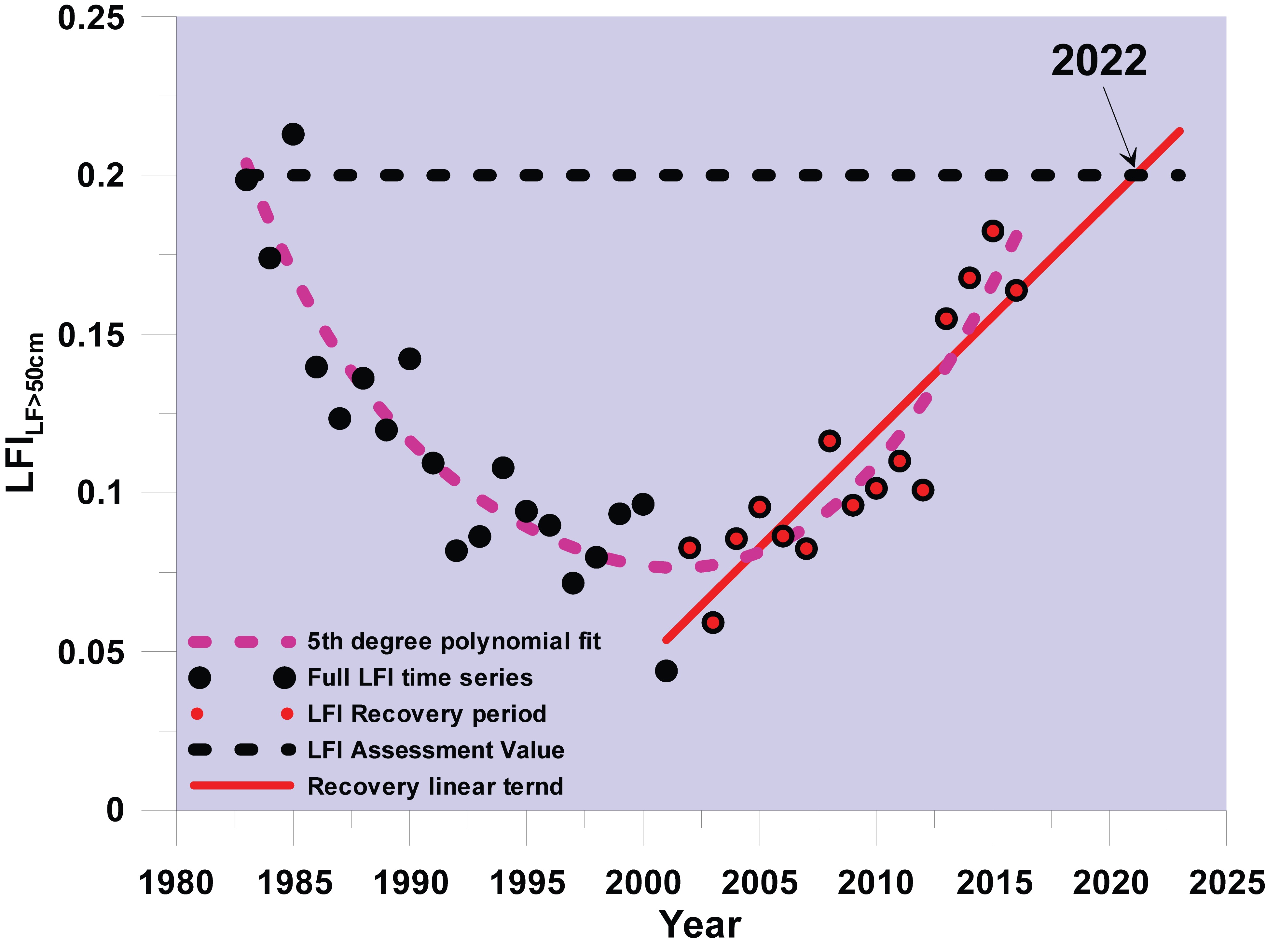
Figure b. Large Fish Index (LFI) time series derived from the GNSIntOT1 (January to March) survey showing the recovery trend and the date at which demersal fish community is expected to meet the ‘assessment value’
GNSIntOT3 Survey
- The assessment based on the GNSIntOT3 survey corroborates the GNSIntOT1 assessment outcome;
- LLF = 50 cm;
- The GNSIntOT3 LFI time series correlated with the GNSIntOT1 LFI time series with a one-year offset (Figure c), such that Quarter(Q)1y ≈ Quarter(Q)3y-1. So both surveys are thus influenced by the same recruitment event. This gives a relationship of LFIQ3 = 1.098LFIQ1, which implies a GNSIntOT3 LFI assessment value of 0.22;
- 2016 LFI>50cm value is 0.211 and average LFI>50cm value over period 2014–2016 is 0.198;
- The Greater North Sea LFI is currently below its assessment values;
- The LFI>50cm low point (0.041) occurred in 2000;
- Strong recovery from 2001 onwards with the LFI>50cm increasing annually by 0.098 on average;
- Linear trend fitted to recovery period suggests the 0.2 assessment value should be met by 2020 (Figure d);
- Residuals from this trend in last three years of the time series are mostly positive suggesting a HIGH level of confidence that the assessment values will be achieved by 2018; and
- Furthermore, LFI2015 (0.191) < LFI2016 (0.211), which because of the 1-year offset, suggests that the GNSIntOT1 LFI2017 value will be higher than the LFI2016 value.
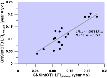
Figure c. Correlation between the GNSIntOT1 and GNSIntOT3 Large Fish Index (LFI) time series
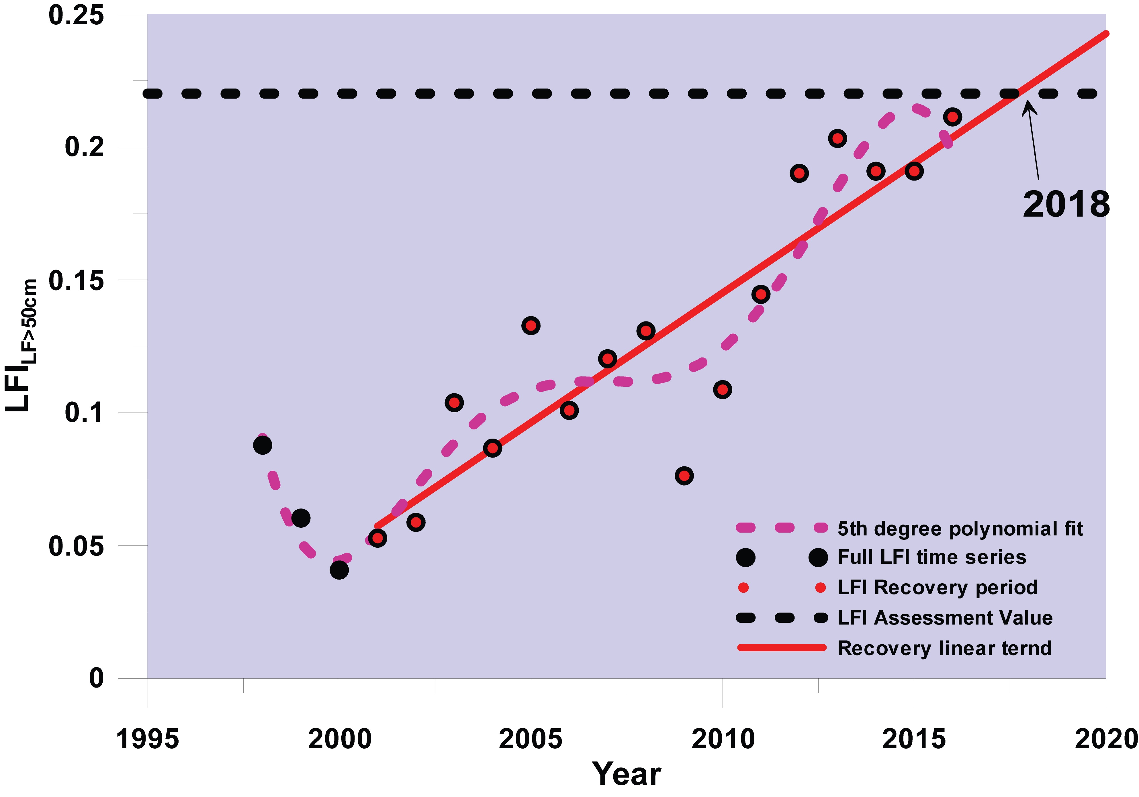
Figure d. Large Fish Index (LFI) time series derived from the GNSIntOT3 (July to September) survey showing recovery trend and the date at which demersal fish community is expected to meet the ‘assessment value’
Other Greater North Sea Surveys
Other than between the two near-regional scale international bottom trawl surveys, correlation between LFI time series derived from groundfish surveys operating in the Greater North Sea was low. Several factors contribute to this, such as: variation in spatial coverage between surveys; surveys operating in different parts of the region (e.g. GNSFraOT4 principally in the English Channel); variation in the extent of area covered (e.g. GNSGerBT3 only 20 ICES statistical rectangles); and data concerns with the last two years (or first 26 years) of the GNSFraOT4 survey.
The main Greater North Sea assessment therefore relies on the GNSIntOT1 and GNSIntOT3 surveys.
Excluding the last two years of the GNSFraOT4 survey, then the GNSFraOT4 and GNSEngBT3 surveys show lowest LFI values in the mid-1990s with substantial increases to the current time.
The GNSGerBT3 and GNSNetBT3 surveys indicate variation in LFI, but show no substantial improvement in recent years over LFI values in the early 2000s.
Greater North Sea Overall Outcome Summary
Demersal fish community size composition in the Greater North Sea is currently below assessment values. The two surveys supporting the main assessment both suggest that size composition has recovered strongly from its most disturbed condition at the turn of the century. Extrapolation of current recovery trends in these two surveys suggests that LFI assessment values should be met before the next European Union Marine Strategy Framework Directive (MSFD) assessment in 2024. Time lags involved in the LFI response to changing fishing pressure infer that the necessary management to meet these assessment values is already in place – there is no need for further restriction of fishing activity. However, because assessment values have not been achieved, neither is there any evidence to support a case for any relaxation of the current fisheries management regime.
Celtic Seas Assessment
Only one LFI time series based on a continuing survey (derived from the CSScoOT1 survey) correlated closely with the now ceased United Kingdom west coast groundfish survey (WCGFS) LFI time series that was analysed by Shephard et al. (2011) and used to derive the original LFI for the Celtic Seas. This was the only survey with a start date similar to that for the WCGFS, thus the CSScoOT1 time series fully encompassed that of the WCGFS. All other surveys started six to 17 years later than the WCGFS, and because it ceased about ten years before the end of the extant survey times series, in many cases the period of overlap was limited, reducing the likelihood of close correlations. Assuming the United Kingdom WCGFS assessment value of 0.42, the linear regression with the CSScoOT1 survey suggested an equivalent assessment value of 0.43 for the CSScoOT1 survey (Figure e)
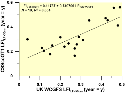
Figure e. Correlation between the United Kingdom west coast groundfish survey (WCGFS) and CSIntOT1 Large Fish Index (LFI) time series
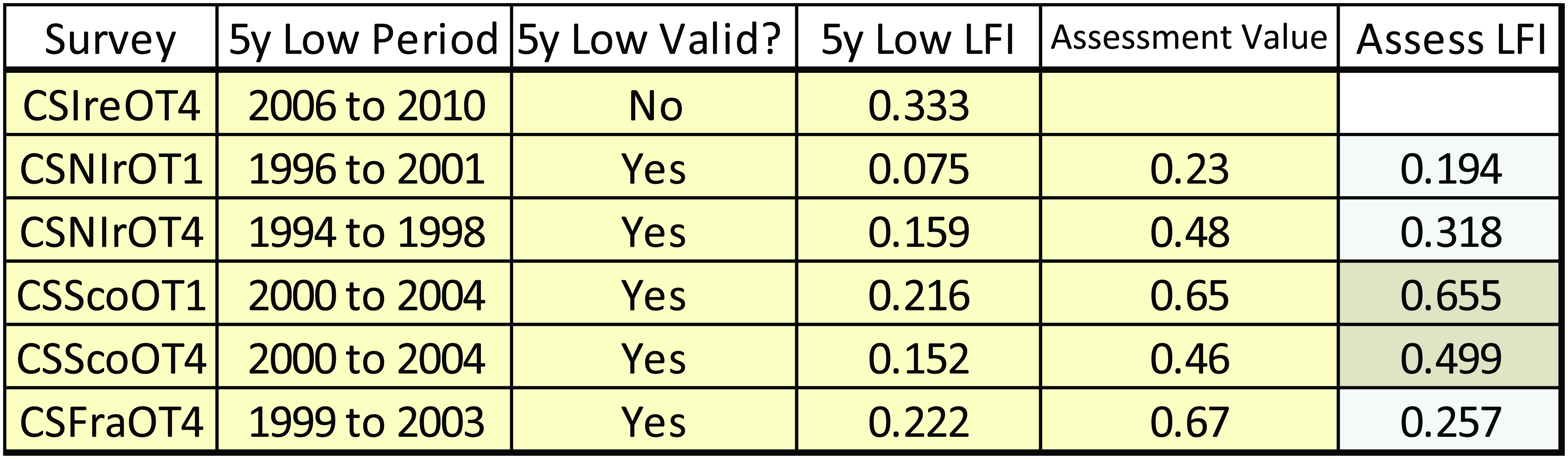
Five of the six on-going otter trawl surveys operating in the Celtic Seas had a five year average low LFI period within the 11 years, 1994–2004, and so were considered suitable for application of the ‘three times’ multiplier to derive assessment values (Table d). The last LFI values in the time series only exceeded the assessment values derived in this way in the CSScoOT1 and CSScoOT4 surveys, both of which operate in the northern part of the region (Table d).
The last LFI values in the time series meet their respective assessment values in only two surveys, CSScoOT1 and CSScoOT4, suggesting that management objectives for demersal fish community size composition have only been achieved in the northern part of the Celtic Seas.
Table d. Assessment outcome for five otter trawl surveys with valid five year low moving average Large Fish Index (LFI) periods and so eligible for assessment against assessment values derived as three times the five year low moving average LFI value
Recovery periods were defined as starting the year after the lowest LFI value was observed. For four surveys, linear trends fitted to the recovery period LFI data suggested that assessment values would be met prior to the next MSFD assessment phase in 2024, and for three surveys, assessment values would be met prior to 2020 (Figure f). These surveys are in effect two pairs, where each pair covers a different part of the Celtic Seas region. But within each pair, the surveys are separated temporally suggesting that assessment outcomes are independent of survey seasonality, corroborating similar evidence obtained in the Greater North Sea. The four surveys ultimately meeting assessment values cover the area to the north and east of Ireland. The surveys failing to meet assessment values cover the area to the south and west of Ireland.
Survey LFI trends in the last 15 to 20 years suggest that assessment values for the demersal fish community will be achieved within the next decade in the north and east of the Celtic Seas region but not the south and west.
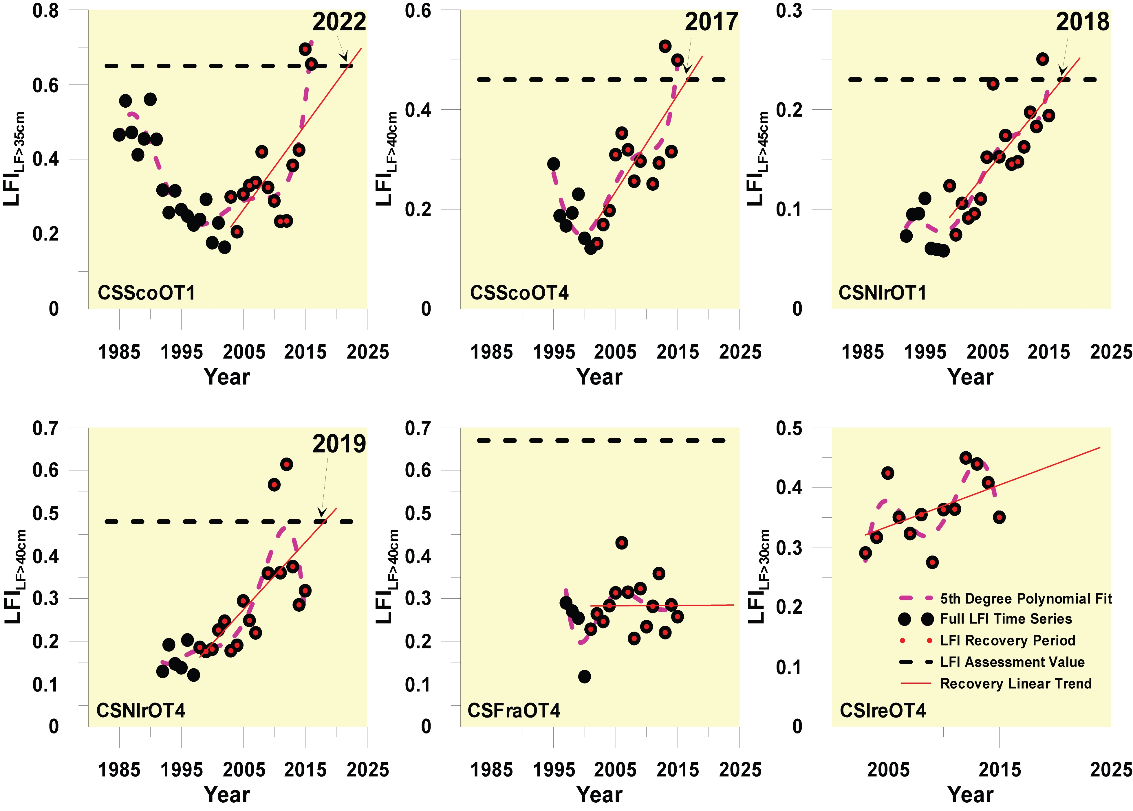
Figure f. Large Fish Index (LFI) time series derived from the CSScoOT1, CSScoOT4 CSNIrOT1, CSNIrOT4 CSFraOT4 and CSIreOT4 demersal fish surveys showing recovery trends and the date at which demersal fish communities are expected to meet assessment values
One beam trawl survey, CSEngBT3, operates in the southern part of the Celtic Seas region. The survey began too recently to include a suitable reference period to define an appropriate assessment value. Being a beam trawl survey, use of the ‘three times’ multiplier on the five year average lowest LFI period derived from Shephard et al. (2011) was not considered appropriate.
However a positive trend seems to be present (Figure g), and as such this survey also tends to corroborate the positive recent trend observed in the CSIreOT4 survey. However, like the CSIreOT4 survey, the recovery rate is low, with an annual LFI increase of just 0.0056. Given the lowest observed LFI value in the time series (0.25 in 2000), this recovery rate suggests that several decades might be required before any substantive increase in the size composition of the demersal fish community sampled by this survey is achieved.
Analysis of the only beam trawl survey operating in the Celtic Seas region does not alter the earlier conclusion. Demersal fish size composition in the southern part of the Celtic Seas region is likely to not meet assessment values and is only recovering slowly.
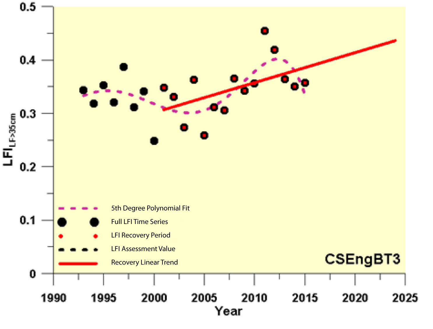
Figure g. Large Fish Index (LFI) time series derived from the CSEngBT3 survey showing the recovery trend
Confidence Assessment
There is medium / high confidence in the assessment methodology and most of the assessment methodology has been published in the peer-reviewed literature and already used in other areas. However, there are some new elements on assessment value setting that have been developed specifically for this assessment.
There is high confidence in data availability, and there are no significant data gaps and thus sufficient spatial coverage.
Conclusion
The recovery in the proportion of large fish in the demersal fish community reported in the Greater North Sea in Quality Status Report (QSR) 2010 has continued in the period to 2015. Recovery is also evident in a large part of the Celtic Seas region.
Assessment values are met only in the northern part of the Celtic Seas. Elsewhere assessment values could be achieved by 2022 if the current pressures levels are not increased. Exceptions were observed, notably in the south and west of the Celtic Seas region, where evidence of recovery is lacking, or the recovery rate was so low that it could take more than a decade before demersal fish size composition achieves the assessment value, unless current levels of pressure are reduced.
The time-lagged response of the Large Fish Index (LFI) to variation in fishing pressure means that where assessment values are met, or where they are not met but recovery is underway, measures necessary to restore demersal fish size composition are probably already in place. Additional measures may be required where assessment values are not met and evidence of recovery trends is either absent or weak. However, since LFI assessment values have generally yet to be achieved over most of the area assessed, any relaxation of management would be premature.
Knowledge Gaps
Knowledge gaps focus on: the lack of empirical data (including historical data) or appropriate models to inform Large Fish Index (LFI) assessment value setting; the lack of a single universal protocol to determine the optimal length value defining ‘large fish’ for all surveys; the effects of warming sea temperature on LFI assessment values and on demersal fish size composition recovery rates; and, a full understanding of relationships between all human pressures and their impact on the full demersal fish community, not just the commercial stocks. Future development of the indicator should explore the potential of spatial sub-divisional assessments.
The availability of survey data at times early enough to be considered suitable as reference periods makes the use of an empirical approach to set assessment values for the majority of the current groundfish surveys extremely difficult.
To support assessment in the future, a modelling approach to determining suitable Large Fish Index (LFI) assessment values will be necessary. Simple statistical models incorporating the relationship between variation in average community level fishing mortality and the LFI response have proved useful in the past in demonstrating that the management measures necessary to achieve LFI assessment values are already in place (Greenstreet et al., 2011, 2012; Shephard et al., 2011; Modica et al., 2014). However a more rigorous approach to assessment value setting is likely to be required. Several community models have been used to explore the nature of the response of the LFI to variation in fishing pressure on demersal fish communities, but in many instances these involve ‘simulated’ communities (Fung et al., 2013; Shephard et al., 2013); communities that do not actually exist and which therefore can shed little light on specific assessment values for specific survey-derived LFI time series. What is required are models that are parameterised to represent specific fish communities, sampled by particular surveys, and subject to specified patterns of fishing activity, such as the model developed for the North Sea demersal fish community by Spiers et al. (2016).
The three major studies that have been principally responsible for the development and application of the LFI across the OSPAR Maritime Area all fitted a 5th degree polynomial function to a range of LFI time series, each using a different length value to define ‘large fish’ (LLF), in order to find the LLF value that produced the LFI series with the highest signal-to-noise ratio (i.e. the LFI time series with the best fit) (Greenstreet et al., 2011; Shephard et al., 2011; Modica et al., 2014). However, for several of the surveys analysed to support the current assessment, this approach was considered unsatisfactory. Rather than finding the optimum signal-to-noise ratio, the LFI time series best fitted by a 5th degree polynomial function appeared to have had almost all the signal eliminated along with the noise. In such cases, a more subjective approach to selecting the optimum LFI time series had to be adopted, and this was not desirable. To support future assessment, effort should be directed towards developing a single protocol for determining the optimum LLF that can be applied universally.
A further knowledge gap relates to the effects of climate change on the LFI. Demersal fish size composition can only recover from a perturbed state through natural population dynamics operating at a population level and cascading through communities. Communities of large-bodied species will only regain a more natural size composition through the production of relatively large recruitment cohorts that are subsequently allowed the time to grow to exceed LLF values.
In many species, individuals in colder environments grow more slowly than individuals in warmer environments, but are larger as adults. This widespread pattern is embodied by two well-established rules: Bergmann’s rule, which describes the association between temperature and body size in natural environments, and which gives rise to gradients of increasing body size with latitude, and the temperature-size rule, which describes reaction norms relating temperature to body size in laboratory experiments (Angilletta and Dunham, 2003). In recent years, rising sea temperatures in the North Sea, associated with climate change, have been linked to an increase in demersal fish species richness (Hiddink and ter Hofstede, 2008; ter Hofstede et al., 2010; Simpson et al., 2011), attributed to an influx of, or an increase in the abundance of, species with a southern Lusitanian biogeographic affinity (Beare et al., 2004a,b,c). Owing to Bergmann’s rule, these Lusitanian species tend to be smaller bodied than their northern Boreal counterparts (Genner et al., 2004, 2010). Increased abundance of smaller bodied Lusitanian species, associated with rising sea temperature, certainly holds implications for LFI assessment values, particularly in the more northerly regions of the Northeast Atlantic. In the North Sea, cod (Gadus morhua) and saithe (Pollachius virens) accounted for about 60% of the biomass of ‘large’ fish (Greenstreet et al., 2011). The decline in the cod stock through the 1980s was responsible for a large fraction of the coincidental reduction in the LFI. Recent and future recovery of the LFI could depend heavily on future cod and saithe biomass trajectories. Both species are Boreal, and population size changes and distribution shifts have been documented, particularly for cod, that might suggest that the future prognosis for both species in the North Sea might not be good. In particular, both species have experienced marked and prolonged reductions in recruit production, hindering recovery in their stock biomass, and potentially slowing recovery in the LFI.
Finally, in order to advise on the most effective management measures to achieve the objectives for the LFI, relationships underpinning the LFI response to variation in the human activities that impact demersal fish communities need to be well understood. All three studies responsible for development of the LFI in the Northeast Atlantic examined the relationship between the LFI and a metric of community averaged fishing mortality. In reality, however, this mortality metric was just a weighted average of the annual fishing mortality on the few assessed demersal fish stocks in each study area. To date, few studies have attempted to estimate fishing mortality rates on non-commercial species (Piet et al., 2009), but such information could contribute much to a better understanding of how fishing affects the LFI.
Angilletta M.J. Jr., Dunham, A.E. 2003. The temperature-size rule in ectotherms: simple evolutionary explanations may not be general. American Naturalist, 162, 332-342.
Beare, D., Burns, F., Greig, A., Jones, E.G., Peach, K., Kienzle, M., McKenzie, E., and Reid, D.G. 2004c. Longterm increases in prevalence of North Sea fish having southern biogeographic affinities. Marine Ecology Progress Series, 284: 269 – 278.
Beare DJ, Burns F, Peach K, Portilla E, Greig A, McKenzie E, Reid DG. 2004a. An increase in the abundance of anchovies and sardines in the north-western North Sea since 1995. Global Change Biology 10: 1209–1213.
Beare DJ, Burns F, Peach K, Reid DG. 2004b. Red mullet migration into the northern North Sea during late winter. Journal of Sea Research 53: 205–212.
Fung, T., Farnsworth, K.D., Reid, D.G., Rossberg, A.G., 2012. Recent data suggest no further recovery in North Sea Large Fish Indicator. ICES Journal of Marine Science, 69, 235–239.
Fung, T., Farnsworth, K.D., Shephard, S., Reid, D.G., Rossberg, A.G., 2013. Why the size structure of marine communities can require decades to recover from fishing. Marine ecology Progress Series, 484, 155.
Genner MJ, Sims DW, Southward AJ, Budd GC, Masterson P, McHugh M, Rendle P, Southall EJ, Wearmouth VJ, Hawkins SJ. 2010. Body size-dependent responses of a marine fish assemblage to climate change and fishing over a century-long scale. Global Change Biology 16, 517–527.
Genner, M. J., Sims, D. W., Wearmouth, V. J., Southall, E. J., Southward, A. J., Henderson, P. A., and Hawkins, S. J. 2004. Regional climate warming drives long‐term community changes of British marine fish. Proceedings of the Royal Society of London, Series B, 271, 655 – 661.
Greenstreet, S.P.R., Rogers, S.I., Rice, J.C., Piet, G.J., Guirey, E.J., Fraser, H.M., Fryer, R.J. 2011. Development of the EcoQO for fish communities in the North Sea. ICES Journal of Marine Science, 68, 1-11.
Greenstreet, S.P.R., Rogers, S.I., Rice, J.C., Piet, G.J., Guirey, E.J., Fraser, H.M., Fryer, R.J. 2012. A reassessment of trends in the North Sea Large Fish Indicator and a re-evaluation of earlier conclusions. ICES Journal of Marine Science, 69, 343-345.
Heslenfeld, P., Enserink, E. L. 2008. OSPAR Ecological Quality Objectives: the utility of health indicators for the North Sea. ICES Journal of Marine Science, 65, 1392–1397.
Hiddink, J. G., ter Hofstede, R. 2008. Climate induced increases in species richness of marine fish. Global Change Biology, 14, 453–460
Modica, L., Velasco, F., Preciado, I., Soto, M., Greenstreet, S.P.R., 2014. Development of the large fish indicator and associated Ecological Quality Objective for a North-East Atlantic fish community. ICES Journal of Marine Science, 71: 2403-2415.Piet, G. J., van Hal, R., Greenstreet, S. P. R. 2009. Modelling the direct impact of bottom trawling on the North Sea fish community to derive estimates of fishing mortality for non-target fish species. ICES Journal of Marine Science, 66, 1985–1998.
Shephard, S., Fung, T., Rossberg, A.G., Farnsworth, K., Reid, D.G., Greenstreet, S.P.R. & Warnes, S. 2013. Modelling recovery of Celtic Sea demersal fish community size-structure. Fisheries Research, 140: 91-95.
Shephard, S., Reid, D.G., Greenstreet, S.P.R. 2011. Interpreting the Large Fish Indicator for the Celtic Sea. ICES Journal of Marine Science, 68, 1963-1972.
Simpson SD, Jennings S, Johnson MP, Blanchard JL, Schon P-J, Sims DW, Genner MJ. 2011. Continental shelf-wide response of a fish assemblage to rapid warming of the sea. Current Biology 21, 1565–1570.
Spiers, D.C., Greenstreet, S.P.R., Heath, M.R. 2016. Modelling the effects of fishing on the North Sea fish community size composition. Ecological Modelling. 321, 35-45.
ter Hofstede R, Hiddink JG, Rijnsdorp AD. 2010. Regional warming changes fish species richness in the eastern North Atlantic Ocean. Marine Ecology Progress Series, 414, 1–9.
| Sheet reference | BDC17/D401 |
|---|---|
| Assessment type | Intermediate Assessment |
| Context (1) | Biological Diversity and Ecosystems - Targeted actions for the protection and conservation of species, habitats and ecosystem processes |
| Context (2) | OSPAR Publication 356, OSPAR Background Document on the EcoQO on changes in the proportion of large fish and evaluation of the sizebased indicators, 2008. |
| Context (3) | D1 - Biological Diversity |
| Context (4) | D1.7 - Ecosystem Structure |
| Point of contact | OSPAR Secretariat |
secretariat@ospar.org | |
| Metadata date | 2017-05-10 |
| Title | Proportion of large fish (Large Fish Index) |
| Resource abstract | Fishing mortality constrains the age structure of fish communities, reducing the proportion of older individuals. The assessment determines the suite of species constituting the demersal fish community and the length criteria defining large fish. The proportion of the demersal fish biomass that has a length exceeding the length criteria can then be calculated. |
| Linkage | https://www.ospar.org/documents?v=7092 |
| Linkage | https://www.ospar.org/documents?v=7200 |
| Linkage | https://qsr2010.ospar.org/media/assessments/p00406_Evaluation_EcoQO_2010_update.pdf |
| Topic category | Environment |
| Indirect spatial reference | L1.2;L1.3 |
| Countries | BE, DE, DK, ES, FI, FR, IE, NL, NO, PT, SE, UK |
| N Lat | 62.0000000002998 |
| E Lon | 13.0665752428532 |
| S Lat | 48.0000507707265 |
| W Lon | -12.0250000001498 |
| Countries | BE, DE, DK, ES, FI, FR, IE, NL, NO, PT, SE, UK |
| Start date | 1983-01-01 |
| Conditions applying to access and use | https://www.ospar.org/site/assets/files/1215/ospar_data_conditions_of_use.pdf |
| Data Results | https://odims.ospar.org/documents/172/download |