

Status Assessment 2022 - Carbonate Mounds
| Assessment of status | Distribution | Population size (for species) or extent (for habitats) | Condition (for habitats) or Demographics (for species if applicable, e.g. productivity) | Previous OSPAR status assessment | Status (overall assessment) | |
|---|---|---|---|---|---|---|
Region | I | ○ | ||||
| II | ||||||
| III | ||||||
| IV | ||||||
| V | ←→ 1,5 | ←→ 1,5 | ?1,2,3,5 | ● | poor | |
| Assessment of threats | Habitat loss/degradation through physical damage from demersal fisheries | Habitat loss or alteration through community shifts and/or increasing ocean acidification due to climate change | Threat or impact | |
|---|---|---|---|---|
Region | I | |||
| II | NA | |||
| III | NA | |||
| IV | NA | |||
| V | ←→1,2,5 | ?1,3,5 | ←→1,2,5 | |
Explanation to table:
Distribution, Population size, Condition
Trends in status (since the assessment in the background document)
↓ decreasing trend or deterioration of the criterion assessed
↑ increasing trend or improvement in the criterion assessed
←→ no change observed in the criterion assessed
? trend unknown in the criterion assessed
Previous status assessment: If in QSR 2010 then enter Regions where species occurs ( ○) and has been recognised by OSPAR to be threatened and/or declining (● ) based on Chapter 10 Table 10.1 and Table 10.2 . If a more recent status assessment is available, then enter ‘poor’/’good’
Status*(overall assessment)
red – poor
green – good
? – status unknown
NA - Not Applicable
*applied to assessments of status of the feature or of a criterion, as defined by the assessment values used in the QSR 2023 or by expert judgement.
Key Pressure
↓ key pressures and human activities reducing
↑ key pressures and human activities increasing
←→ no change in key pressures and human activities
? Change in pressure and human activities uncertain
Threats or impacts (overall assessment)
red – significant threat or impact;
green–no evidence of a significant threat or impact
Blue cells – insufficient information available
NA – not applicable
1 – direct data driven
2 – indirect data driven
3 – third party assessment, close-geographic match
4 – third party assessment, partial-geographic match
5 – expert judgement
Confidence
Overall, there is medium confidence in the status assessment.
There is medium confidence in the evidence for the Distribution and Extent criteria. Direct data-driven evidence comes from the OSPAR threatened and/or declining habitats database, an increasing number of publicly funded exploration programmes since 2010 to ground-truth and expand Distribution records across Region V, e.g., from Galicia Bank (Somoza et al., 2014) where OSPAR currently has no records, SeaRover2017 (Picton et al., 2021), and from Bonneau et al. (2018) who confirmed ages of SW Rockall corals on Logachev Mound of ~128ka (using U/Th series dating) for carbonate mounds in this area that the OSPAR database does already capture.
Confidence in Distribution could be strengthened either through extensive habitat mapping and ground-truthing programmes in the OSPAR Maritime Area and/or through the use of predictive modelling approaches (e.g., Diesing and Thorsnes, 2018) as these are improving in accuracy and reliability when scaled up to the OSPAR Regions.
There is low to medium confidence in the evidence for the Condition criterion. A major issue is that no Contracting Party undertakes regional scale monitoring of carbonate mounds or Condition of the feature. The OSPAR common indicator BH3 Extent of Physical Damage to Predominant and Special Habitats (OSPAR Commission, 2017), does not have sufficient spatial coverage to allow for an assessment of condition of carbonate mounds and can only be used to partially assess Condition (the indicator is designed to assess “Structure and Function” instead of “Condition” as referred to in the EU Marine Strategy Framework Directive) of United Kingdom offshore reefs which were assessed as being in an “Unfavourable-Bad” status with declining future prospects. Besides partial assessments, direct data-driven evidence for Condition since 2010 has come from various research expeditions that documented presence or abundance of key species (black corals in particular; De Clippele et al. 2019; Picton et al., 2021), quality of abiotic components such as substrate but also marine litter (De Clippele et al., 2019; Picton et al., 2021), and information on processes supporting the feature such as hydrodynamics and food supply including the threats posed by climate change (Soetaert et al., 2016; Lim et al., 2018; van der Kaaden et al., 2021). Climate-ocean state projections with a close geographic match suggest all carbonate mounds in the Wider Atlantic (Region V) are likely to be impacted by climate change by 2100 (Morato et al., 2020; Puerta et al., 2020).
By proxy, there is medium confidence that ongoing threats and impacts from demersal fisheries and lack of fisheries restrictions have contributed to the deterioration of this habitat. This is especially true for those threatened and/or declining listed habitats that occur on carbonate mounds and, according to expert judgement, have high sensitivities to impacts of demersal fishing gears, i.e., cold-water coral reefs, coral gardens and sponge aggregations.
Background Information
- Carbonate mounds were added to the OSPAR list in 2003 (see the Case Report for nomination to OSPAR, 2008; https://www.ospar.org/site/assets/files/44271/carbonate_mounds.pdf
- The feature was last assessed in 2010; https://www.ospar.org/documents?v=7219
The habitat occurs in Arctic Waters (Region 1) I and V, but is listed as Threatened and/or Declining only in OSPAR Region V where clusters of coral carbonate mounds formed by successive periods (>10 000 years) of coral reef development, sedimentation and (bio)erosion are known to occur (Background Document, OSPAR Commission, 2010). The full extent of carbonate mounds in the OSPAR Maritime Area is not fully known yet. - Region V met several Texel-Faial criteria for listing carbonate mound habitat. Condition of habitats and associated epifauna on carbonate mounds still targeted by demersal fisheries will likely decline through physical abrasion from mobile gear (OSPAR Commission, 2008). Carbonate mounds frequently occur in clusters, e.g., in the Rockall and Porcupine Basins they are abundant and concentrated in areas on the basins’ slopes. Since the last assessment, mounds have been discovered on the Iberian margin (Somoza et al., 2014) but require further mapping effort. Habitats on carbonate mounds can be dominated by fragile and long-lived filter- and suspension-feeders that in themselves form other OSPAR Threatened and Declining listed habitats such as Lophelia reefs, deep-sea sponge aggregations and coral gardens, all of which are sensitive to siltation and mortality caused by demersal mobile fishing gear. The topographic highs and hard substrata on many carbonate mounds offer numerous ecological niches from the summit to their flanks, supporting a high biological diversity of invertebrates and fish including those of commercial importance.
- Table 10.3 in the QSR 2010 report (OSPAR, 2010) identified habitat damage to be the main key pressure, which was reinforced by Table 1 in the 2010 carbonate mound status assessment (OSPAR Commission, 2010).
- Carbonate mounds nomination to the Threatened and Declining list in OSPAR’s Case Report 2008/358 (OSPAR Commission, 2008) lists this feature in Region I and V, but only Region V was nominated under Texel-Faial criteria. The 2010 assessment of carbonate mounds (OSPAR Commission, 2010: https://www.ospar.org/documents?v=7219), concluded that habitats associated with the mounds were in decline through damage caused by demersal fisheries. The assessment noted that the OSPAR Maritime Area is globally important for this feature as it contains the greatest concentration and the largest examples of coral carbonate mounds worldwide, with Region V of high importance. Sensitivity of cold-water coral reefs occurring on carbonate mounds was noted, with the 2010 assessment calling for more research on sensitivity of other Threatened and Declining habitats to impacts of demersal fishing gear. The assessment underlined the ecological significance of carbonate mounds in supporting high biodiversity and other Threatened and Declining species such as, e.g., orange roughy. The assessment noted that carbonate mounds were not immediately threatened by anthropogenic activities but that the habitats occurring on carbonate mounds were threatened.
Geographical Range and Distribution
Carbonate mounds occur in Regions I and V, but only Region V was nominated under Texel-Faial criteria (OSPAR Commission, 2008). OSPAR itself does not hold any records of this feature in Region I, as the last status assessment (OSPAR Commission, 2010) used a modified definition to refer to specific types of carbonate mounds that excluded those features in Region I. OSPAR Agreement 2014/10 (OSPAR Commission, 2014) calls for measures only in Region V where these specific types of coral carbonate mounds occur. They tend to cluster in provinces off Ireland, the northwest and southwest Rockall Bank, with a high likelihood of occurrence on Hatton Bank. Recent discoveries of coral carbonate mounds on Galicia Bank (Somoza et al., 2014) extend the known distribution of this feature further across Region V, in close proximity to the Bay of Biscay and Iberian Coast (Region IV). It is highly likely that the known extent of carbonate mound distribution in Region V in particular will expand as exploration continues.
Main method of assessment: 3b

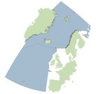
Figure 1: Distribution of carbonate mounds in the OSPAR maritime area
Extent
There has been no actual change in the extent of carbonate mounds since the last assessment, the feature being geologically stable over thousands to millions of years, e.g., the latter being the case of Challenger Mound in the Porcupine Seabight. High densities of carbonate mounds occur around Rockall Bank, Hatton Bank, the Porcupine Seabight and Porcupine Bank (Figure 2). However, a recent discovery of coral carbonate mounds on Galicia Bank significantly expanded the known extent of this feature on the eastern boundary of Region V (Figure 3).
It is anticipated that more mounds will be discovered in the future, thus our knowledge of their extent will change. In the future, extent is unlikely to change unless an industry sector develops that has the potential to damage or remove significant portions of a carbonate mound, e.g., extensive aggregate removal.
Main method of assessment: 3b
")
Figure 2: Extent of carbonate mounds in Region V, indicating the recent discoveries of carbonate mounds on Galicia Bank (yellow arrow)

Figure 3: Recent discovery of two carbonate mound provinces on Galicia Bank significantly expand the known extent of this feature with Region V, in very close proximity to OSPAR Region IV shown here
Condition
Overall, condition of carbonate mounds is not known in the whole OSPAR Maritime Area, but there has been an improvement in the understanding of current and future prospects at a limited number of carbonate mounds since the last assessment in 2010. New evidence is based mainly on data from third parties but note that these have very limited spatial and temporal extent. Proxy data based on MPAs, management measures, and on demersal fisheries from OSPAR and third parties are available.
This evidence reveals a wider range of other Threatened and Declining listed habitat types associated with carbonate mounds than was known in 2010. These include different types of Vulnerable Marine Ecosystems (VMEs) and VME indicator taxa (de Clippele et al., 2019; Picton et al., 2021; Price et al., 2021). High associated biological diversity including shrimps, crabs, crinoids and ophiuroids have been recorded now, with the Challenger Mound topped by Cidaris cidaris urchin aggregations (Picton et al., 2021). The ecological importance of these features to demersal fish and especially early life history stages of oviparous elasmobranchs is supported by new evidence. Underwater camera transects show lost fishing gear on carbonate mounds and trawl marks. Regional fisheries pressure proxies and introduced management measures suggest a reduction of pressures for some mounds but possible intensification of pressures on others.

Figure 4: Distribution of carbonate mound records with respect to MPAs and fisheries closures within OSPAR Region V
Carbonate mounds are not listed under the Habitats Directive or regularly assessed by other 3rd parties, but Reefs are Annex I listed (Reefs – 1170). Every six years, Member States of the European Union are required under Article 17 of the Directive to report on implementation of the Habitats Directive. Conservation Status (2013-2018) of Marine Atlantic Reef habitats (Habitats Directive, Article 17) by EU Member States were last recorded as “Unfavourable-Inadequate (Ireland) and “Unfavourable-Bad” (UK) (see https://jncc.gov.uk/jncc-assets/Art17/H1170-OFF-Habitats-Directive-Art17-2019.pdf). Kazanidis et al. (2020) conducted a mock-GES assessment for Porcupine Seabight based on expert judgement to conclude that carbonate mounds in this sector of Region V were likely to have good environmental status despite fisheries pressure elsewhere.
It is estimated that 59% of carbonate mounds in Region V are not spatially protected other than by the Deep-Sea Access Regulations (Figure 4).
Limited but highly detailed studies on hydrodynamic and food supply controls on carbonate mound condition suggest declining future prospects, but these cannot yet be evidenced directly. Carbonate mounds in Region V are tightly coupled to hydrodynamics, linking mixing, nutrients and food supply to coral mound growth, mound coalescence, and ecosystem functioning (Mohn et al., 2014; Cyr et al., 2016; Lim et al., 2018; de Froe et al., 2019). Expert judgement concluded that carbonate mound structure and functioning, and thus habitat quality, are highly sensitive and likely to deteriorate in future due to climate-induced changes in primary production, local hydrodynamics, organic matter flux and ocean acidification. Combined with the lack of protection from demersal fisheries, the occurrence of other Threatened and Declining habitats, overall habitat quality and the processes that support the feature could decline in the near future.
Main method of assessment: 3b
Threats and Impacts
Demersal fisheries
Since the last QSR assessment in 2010 (OSPAR Commission, 2010), fisheries and climate change continue to pose detrimental threats and impacts on carbonate mounds in Region V. However, such pressures could not be confidently assessed across the entire region due to lack of data accessibility to perform this assessment (e.g., vessel monitoring system (VMS) data would provide for a more robust estimate of exerted fishing pressure) and the timescales for climate-induced changes to have impacted carbonate mounds in ways that can be measured.
Overall, habitat loss/degradation through physical damage from demersal fisheries has likely declined in Region V over the time-period 2010 to 2016, but demersal fisheries activity proxied by subsurface bottom fishing intensity (swept-area ratio) seem to have intensified in particular areas within Region V (Figure 5), potentially indicating fishing effort displacement from carbonate mounds like Hatton Bank and southwest Rockall to Porcupine Bank.
 submitted by ICES to OSPAR BDC (reported in draft EIHA Feeder Report) since the last assessment in 2010 (left panel) and in 2016 (right panel), showing a possible displacement of bottom fishing activity on Porcupine Bank over time (https://odims.ospar.org/en/submissions/ospar_bottom_f_intensubsur_2016_01/)")
Figure 5: Subsurface bottom fishing intensity (swept-area ratio) submitted by ICES to OSPAR BDC (reported in draft EIHA Feeder Report) since the last assessment in 2010 (left panel) and in 2016 (right panel), showing a possible displacement of bottom fishing activity on Porcupine Bank over time (https://odims.ospar.org/en/submissions/ospar_bottom_f_intensubsur_2016_01/)
Global Fishing Watch automatic identification system (AIS) tracking data were used as proxy for demersal fisheries activity since the introduction of the Deep-Sea Access Regulation EU 2016/2336, which restricts deep-sea fishing to areas already fished in the past and banning trawling below 800m depth. This showed that demersal fisheries pressure has very likely not changed on more than half of the carbonate mounds in OSPAR Region V (Figure 6).
Figure 7 supports the subsurface swept-area ratio data (Figure 5), in that there appears to be reductions in fishing pressures in some places (major and minor reductions totaling 24,6%) and increasing fishing pressure elsewhere (major and minor increases totaling 18,2%), with no change in fishing in 57,1% of areas with carbonate mounds (Figure 7).

Figure 6: Changes in fisheries pressure after 2016 following the implementation of the EU Deep-Sea Access Regulation EU 2016/2336

Figure 7: Change in habitat/fishing pressure overlap pre- and post-introduction of 2016 Deep-Sea Access Regulations in OSPAR Region V, according to analysis of Global Fishing Watch AIS data
Pham et al. (2014) reported 1,9±0,8 items litter/ha on Hatton Bank, 87,5% of which was fishing gear found during ROV/towed camera surveys 2005 to 2011. Separately, 13 ROV dives as part of the SeaRover programme were conducted on carbonate mounds; two dives recorded fishing gear (one with trawl marks) in addition to three dives with plastics as well (Picton et al. 2021).
Key pressure 2: climate change and ocean acidification
Climate change threatens to induce significant shifts in biological communities on carbonate mounds and impact processes that support these features in Region V through altered hydrodynamic regimes, a re-distribution of primary productivity and availability of organic matter to the seafloor, and ocean acidification, e.g., for the latter, ICES (2014) predicted that under RCP4,5, waters surrounding Hatton and Porcupine Banks will be approaching aragonite undersaturation by 2100. Climate change and ocean acidification impacts on carbonate mounds remain unknown even since the last assessment and may not have either occurred yet or have not been measured in situ on these listed features. However, expert judgement suggests these impacts could have started to take place as even short-term exposure to decreased pH can impact cold-water corals, and these pressures are likely to increase over the next six to 12 years.
Measures that address key pressures from human activities or conserve the species/habitat
(i) Information on implementation status of OSPAR measures
For the 2019 reporting cycle that was received in time for the present status assessment, Ireland had implemented all eight recommendations (3.1(a)-3.1(h)) e.g., Regulation (EU) 2016/2336, European Communities (Birds and Natural Habitats) Regulations (2011-2015), EU Habitats Directive (92/42/EEC), European Union (Birds and Natural Habitats) (Sea-Fisheries) Regulations (2013-2014). Six SACs have been designated to protect EU Habitats Directive listed Reef habitat incorporating Carbonate Mounds.
The UK had implemented four of the eight Recommendations, e.g., the full extent of verified carbonate mound records in the Hatton Bank candidate SAC (the only location of this feature in UK waters) are now closed to bottom-contact fishing operations under NEAFC Recommendation 19 2014; Protection of VMEs in NEAFC Regulatory Areas, as amended by Recommendation 09:2015 and 10:2018. EU regulation 2016/2336, which bans the use of bottom trawls in depths below 800 m in the North-East Atlantic, affords additional protection to carbonate mounds in depths below 800 m. The UK did not implement anything new since 2016 regarding 3.1(c) consider monitoring distribution, extent and quality, 3.1 (d) consider ways to broaden the knowledge base on carbonate mounds with other relevant actors or seeking ways to gather new data, 3.1(e) consider sites for MPAs and the OSPAR MPA network, or 3.1(h) consider acting within the framework of other competent authorities.
By 2019, Spain had also implemented four of the eight. e.g., Banco de Galicia has now been designated as a Site of Community Importance (SCI) under Ministerial Regulations AAA/1299/2014 of 9 July 2014 and AAA/2280/2014, of 1 December 2014.They have also been included in the OSPAR MPA Network in 2014 and 2016. Spain did not implement 3.1(a) on implementing new legislation, (b) consider management effectiveness, (f) consider minimizing adverse impacts or (h) consider acting within the framework of other competent authorities.
Notably, it is not apparent from the 2019 Implementation Reports whether it has been determined what, if any, further measures are needed to address potential climate change impacts.
(ii) Actions taken beyond the scope of the OSPAR measure, e.g,. by other competent authorities OR to address threats to the species outside the OSPAR area
In total, 58,6% of carbonate mounds in Region V remain unprotected either by MPAs or fisheries management measures besides the Deep-Sea Regulation 2016/2336 with 17% of carbonate mounds protected from fisheries by NEAFC closures and 16,5% designated as MPAs (Figure 4). NEAFC closures are therefore the more common type of action taken to address key pressures and threats to carbonate mounds in Region V to date (Figure 8).

Figure 8: Marine protected areas and NEAFC fisheries closures in Region V
UNGA Resolution 61/105 calling for measures such as “move-on” rules for fishing vessels related to encounters of specific quantities of VME indicator taxa has been implemented through NEAFC Recommendation 19 (2014). Within EU waters, Regulation (EU) 2016/2336 restricts bottom fishing >400 m to the 2009 to 2011 fishing footprint, prohibits bottom fishing >400 m where VMEs are known or likely to occur (through designation of VME closures) and places a complete ban on bottom trawling deeper than 800 m. Within UK waters, regulation (EU) 2016/2336 is transposed into the Common Fisheries Policy and Aquaculture (Amendment etc.) (EU Exit) Regulations 2019, with the same fishing restrictions and prohibitions in place.
The zero Total Allowable Catch (TAC) for orange roughy (another Threatened and Declining listed feature) implemented in 2010 until 2024 will also have reduced fishing pressures on carbonate mounds.
The Convention on Biological Diversity’s process of the identification of Ecologically or Biologically Significant marine Areas (EBSAs; CBD/EBSA/WS/2019/1/4) has resulted in the Hatton and Rockall Banks and the Hatton-Rockall Basin being proposed as an EBSA via the CBD’s 15th Conference of the Parties (not concluded at the time of publication). Identification carries no management measures, but the evidence collected in the description process can be used to inform area-based management tools. For carbonate mounds, the evidence used for the EBSA criterion on Naturalness was also used as evidence for Threats and Impacts in this assessment, noting human impacts on Hatton Bank in the form of lost fishing gear for example (Pham et al., 2014).
Conclusion (including management considerations)
The condition of carbonate mounds is likely deteriorating based on multiple lines of evidence mostly from demersal fisheries. Evidence from multiple sources suggest possible displacement and intensification of fisheries activity in some areas with carbonate mounds, and direct data-driven evidence shows trawl marks and lost fishing gear on carbonate mounds. There is an on-going lack of fisheries protection and/or MPAs designated for including carbonate mounds, with 58% of carbonate mounds covered by nothing more than the EU Deep-Sea Regulation 2016/2336. Yet high densities of coral framework and particularly the living coral exists above 800 m (van der Kaaden et al., 2021). Climate change and ocean acidification is increasing but evidence of impacts since the QSR 2010 assessment is still lacking.
The feature continues to meet the Texel-Faial criteria and there is now an even stronger evidence base for the pressures affecting the habitat (resulting in decline of habitats found on carbonate mounds), the ecological significance of carbonate mounds, their sensitivity and threats. A comment on rarity: since coral carbonate mounds of Holocene origins are not included in the current OSPAR definition (thus excluding mounds in OSPAR Region I and some in Region V) there is increased perception of rarity, but, regardless of definition, the OSPAR Maritime Area is an important area for this feature worldwide.
Overall, there was low to medium confidence in this status assessment, due mainly to the heavy use of proxy-based data on fisheries pressures and efforts to extrapolate results from spatially and temporally restricted but highly detailed studies on carbonate mound condition.
In terms of management, implementation reporting appears uneven across Contracting Parties (Spain, UK, Ireland) but the full reporting process was not considered. Many area-based management tools such as SACs, SCIs, and NEAFC closures have been implemented since 2010, but still 58% of carbonate mounds are not covered by any management measure beyond the EU ban on demersal fishing at depths >800m with the majority of the living coral cover occurring at shallower depths (van der Kaaden et al., 2021). Additionally, Ireland has banned new oil and gas exploration on its shelf, which may de facto help protect carbonate mounds from impacts from the hydrocarbon sector.
There was no explicit reporting on climate change under Recommendation 3.1b – “assessing whether existing management measures for the protection of carbonate mounds are effective, and determine whether further measures are needed to address the key threats, including the potential impacts from climate change and ocean acidification”.
Overall, it is anticipated that a 10-year cycle of re-assessment is required. This extends the 6-year cycle suggested by the earlier status assessment in 2010 as it was thought at the time of the current assessment that changes would not be detectable in under a decade.
Knowledge Gaps
Overall, the present status assessment suffered from insufficient direct data-driven evidence. Specifically, this is an issue for assessing distribution and extent (though that gap is closing) but particularly condition as there is still no regional monitoring programme implemented by any Contracting Party. This is the most significant issue with sufficiency of data and therefore evidence. A coordinated monitoring programme across all deep-sea threatened and/or declining listed habitats could solve many data deficiencies. Vessel Monitoring System (VMS) data would also have significantly advanced this assessment, even if coarsely gridded.
Further consideration of a technical definition of the habitat should be progressed to determine whether the next cycle should consider the full range of carbonate mounds (and thus Region I) and take the next steps in recording these data in the OSPAR threatened and/or declining habitats database.
Changes in relation to natural variability (e.g., distribution of habitats over space and time, environmental drivers of variability, and the roles that ocean physics and dynamics have in structuring carbonate mounds and the processes that support them) are not well investigated and such studies are required to increase the evidence base for future assessments
Method used
Main source of information:
- OSPAR data assessment only
- Assessment derived from third party assessment
- Assessment derived from a mix of OSPAR data assessment and assessments from third parties
Assessment is based upon:
a) complete survey or a statistically robust estimate (e.g. a dedicated mapping or survey or a robust predictive model with representative sample of occurrence data, calibration and satisfactory evaluation of its predictive performance using good data on environmental conditions across entire species range);
b) based mainly on extrapolation from a limited amount of data (e.g. other predictive models or extrapolation using less complete sample of occurrence and environmental data);
c) based mainly on expert opinion with very limited data;
d) insufficient or no data available.
Bonneau, L., Colin, C., Pons-Branchu, E., Mienis, F., Tisnerat-Laborde, N., Blamart, D., Elliot, M., Collart, T., Frank, N., Foliot, L., Douville, E. 2018. Imprint of Holocene climate variability on cold-water coral reef growth at the SW Rockall Trough Margin, NE Atlantic. Geochemistry, Geophysics, Geosystems 19: 2437-2452
Cyr, F., van Haren, H., Mienis, F., Duineveld, G., Bourgault, D. 2016. On the influence of cold-water coral mound size on flow hydrodynamics, and vice versa, Geophysical Research Letters 43: 775–783
De Clippele, L.H., Huvenne, V.A.I., Molodstova, T.N., Roberts, J.M. 2019. The diversity and ecological role of non-scleractinian corals (Antipatharia and Alcyonacea) on scleractinian cold-water coral mounds. Frontiers in Marine Science 6: 184
de Froe, E., Rovelli, L., Glud, R.N., Maier, S.R., Duineveld, G., Mienis, F., Lavaleye, M. van Oevelen, D. 2019. Benthic oxygen and nitrogen exchange on a cold-water coral reef in the north-east Atlantic Ocean. Frontiers in Marine Science 6: 665
Diesing, M., Thorsnes, T. 2018. Mapping of cold-water coral carbonate mounds based on geomorphometric features: an object-based approach. Geosciences 8: 34.
Kazanidis, G., et al. 2020 Assessing the environmental status of selected North Atlantic deep-sea ecosystems. Ecological Indicators 119: 106624
Lim, A., Huvenne, V.A.I., Vertino, A., Spezzaferrie, S., Wheeler, A.J. 2018. New insights on coral mound development from groundtruthed high resolution ROV-mounted multibeam imaging. Marine Geology 403: 225-237
Mohn, C. Rengstorf, A., White, M., Duineveld, G., Mienis, F., Soetaert, K., Grehan, A. 2014. Linking benthic hydrodynamics and cold-water coral occurrences: a high-resolution model study at three cold-water coral provinces in the NE Atlantic. Progress in Oceanography 122: 92-104
Morato, T. et al. 2020. Climate-induced changes in the suitable habitat of cold-water corals and commercially important deep-sea fishes in the North Atlantic. Global Change Biology 26: 2181-2202
OSPAR. 2010. Quality Status Report 2010. OSPAR Commission, London. 176pp
OSPAR Commission. 2008. Case Reports for the OSPAR List of Threatened and/or Declining Species and Habitats: 191-194
OSPAR Commission. 2010. Background document for carbonate mounds. 21pp
OSPAR Commission. 2014. OSPAR Recommendation 2014/10 on furthering the protection and conservation of carbonate mounds in Region V of the OSPAR maritime area. OSPAR 14/21/1, Annex 15
OSPAR Commission. 2017. OSPAR CEMP Guidelines Common Indicator: BH3 Extent of Physical damage to predominant and special habitats. OSPAR Agreement 2017-09
Pham, C.K. et al. 2014. Marine litter distribution and density in European Seas, from the shelves to deep basins. PLoS One 9: e95839
Picton, B.E., Morrow, C.C., Scally, L., Pfeiffer, N., McGrath, F. 2021. Sensitive Ecosystem Assessment and ROV Exploration of Reef (SeaRover), Synthesis Report. Report prepared by MERC Consultants Ltd. on behalf of the Marine Institute, Galway 161 pp
Price, D.M., Lim, A., Callaway, A., Eichhorn, M.P., Wheeler, A.J., Lo Iacono, C., Huvenne, V.A.I. 2021. Fine-scale heterogeneity of a cold-water coral reef and its influence on the distribution of associated taxa. Frontiers in Marine Science 8: 556313
Puerta, P., Johnson, C., Carreiro-Silva, M., Henry, L.-A., Kenchington, E., Morato, T., Kazanidis, G., Rueda, J.L., Urra, J., Ross, S., González-Irusta, J.-M., Arnaud-Haond, S., Orejas, C. 2020. Influence of water masses on the biodiversity and biogeography of deep-sea benthic ecosystems in the North Atlantic. Frontiers in Marine Science 7: 239
Soetaert, K., Mohn, C., Rengstorf, A., Grehan, A., van Oevelen, D. 2016. Ecosystem engineering creates a direct nutritional link between 600-m deep cold-water coral mounds and surface productivity. Scientific Reports 6: 35057
Somoza, L., Ercilla, G., Urgorri, V., León, R., Medialdea, T., Paredes, M., Gonzalez, F.J., Nombela, M.A. 2014. De-tection and mapping of cold-water coral mounds and living Lophelia reefs in the Galicia Bank, Atlantic NW Iberia margin. Marine Geology 349: 73-90
van der Kaaden, Mohn, C., Gerkema, T., Maier, S.R., de Froe, E., van de Koppel, J., Rietkerk, M., Soetaert, K., van Oevelen, D. 2021. Feedbacks between hydrodynamics and cold-water coral mound development. Deep Sea Research Part I 178: 103641
Sheet reference:
BDC2022/Carbonate_Mounds