

Socioeconomics of the OSPAR Maritime Area
The North East Atlantic includes a diverse range of environmental conditions and different ecosystems. These play a key role in the types and patterns of human activities in the OSPAR maritime area and associated pressures on the marine environment. The OSPAR Maritime Area provides the basis for a wide range of goods and services including food, transport, energy and amenities for millions of people. Maritime activities are important for the economies of the OSPAR Contracting Parties in terms of gross value added and employment. Many of the activities are expected to increase in the future and new activities will emerge. The consequences of these activities for the marine ecosystem can lead to direct costs for society. On the other hand, many activities directly depend on a good condition of marine waters. While OSPAR has a long history in assessing the state of the marine environment and the pressures from human activities affecting it, OSPAR has only recently begun to work on economic and social analyses. Understanding the linkage between the health of the marine environment and human wellbeing can help support effective management of human activities and the sustainable use of the sea. Under its North-East Atlantic Environment Strategy, OSPAR is developing and refining methodologies, including social and economic analysis of the uses of the OSPAR Maritime Area, to aid future evaluations of whether the North-East Atlantic is used sustainably. This OSPAR work also underpins a coordinated regional approach to economic and social analyses for the North-East Atlantic, which European Union Member States are required to deliver under the Marine Strategy Framework Directive. |

Mud flats in the Wadden Sea one of the diverse ecosystems in the North East Atlantic
This chapter provides preliminary considerations of the methodology associated with assessing the economic and social value of the OSPAR Maritime Area and an initial regional indicator-based economic and social analysis of selected uses of the North-East Atlantic, supported by a description of their spatial distribution.
Economic and social analysis of uses of the sea
Ecosystem goods and services: Linking economic analyses to the use of the marine environment
|
An important driver for the implementation of the concept of ecosystem services is Action 5 of the EU Biodiversity Strategy, which foresees that Member States will, with the assistance of the European Commission, map and assess the state of ecosystems and their services in their national territory by 2014, assess the economic value of such services, and promote the integration of these values into accounting and reporting systems at EU and national level by 2020. In addition, OSPAR’s North East Atlantic Environment Strategy, which has implementing the ecosystem approach as one of its main objectives, is another driver for this work. The Strategy commits OSPAR countries to continue to progressively implement the Ecosystem Approach to the management of human activities in order to reduce impacts on the marine environment, taking into account all pressures from human activities on the marine environment. One of the main strategic directions under this objective is to develop methodologies, including social and economic analysis of the use of the OSPAR Maritime Area, to support evaluations of whether the North-East Atlantic Ocean is used sustainably. Ecosystem goods and services is one such approach that will need to be further developed in a regional context. Based on the DEVOTES project, as well as the INTERREG project VALMER, Börger et al. (2016) presented some interesting case studies on the use of ecosystem services in the marine environment (fisheries, marine protected areas, and underwater noise) that can be used as a source of inspiration for the continued work of OSPAR on socio-economic assessments. Key findings from the implementation of ecosystem services in relation to the EU Water Framework Directive will also be taken into account, such as from ESAWADI (Ecosystem Services Approach for Water Framework Directive Implementation). |
An important driver for the implementation of the concept of ecosystem services is Action 5 of the EU Biodiversity Strategy, which foresees that Member States will, with the assistance of the European Commission, map and assess the state of ecosystems and their services in their national territory by 2014, assess the economic value of such services, and promote the integration of these values into accounting and reporting systems at EU and national level by 2020. In addition, OSPAR’s North East Atlantic Environment Strategy, which has implementing the ecosystem approach as one of its main objectives, is another driver for this work. The Strategy commits OSPAR countries to continue to progressively implement the Ecosystem Approach to the management of human activities in order to reduce impacts on the marine environment, taking into account all pressures from human activities on the marine environment. One of the main strategic directions under this objective is to develop methodologies, including social and economic analysis of the use of the OSPAR Maritime Area, to support evaluations of whether the North-East Atlantic Ocean is used sustainably. Ecosystem goods and services is one such approach that will need to be further developed in a regional context. Based on the DEVOTES project, as well as the INTERREG project VALMER, Börger et al. (2016) presented some interesting case studies on the use of ecosystem services in the marine environment (fisheries, marine protected areas, and underwater noise) that can be used as a source of inspiration for the continued work of OSPAR on socio-economic assessments. Key findings from the implementation of ecosystem services in relation to the EU Water Framework Directive will also be taken into account, such as from ESAWADI (Ecosystem Services Approach for Water Framework Directive Implementation). |
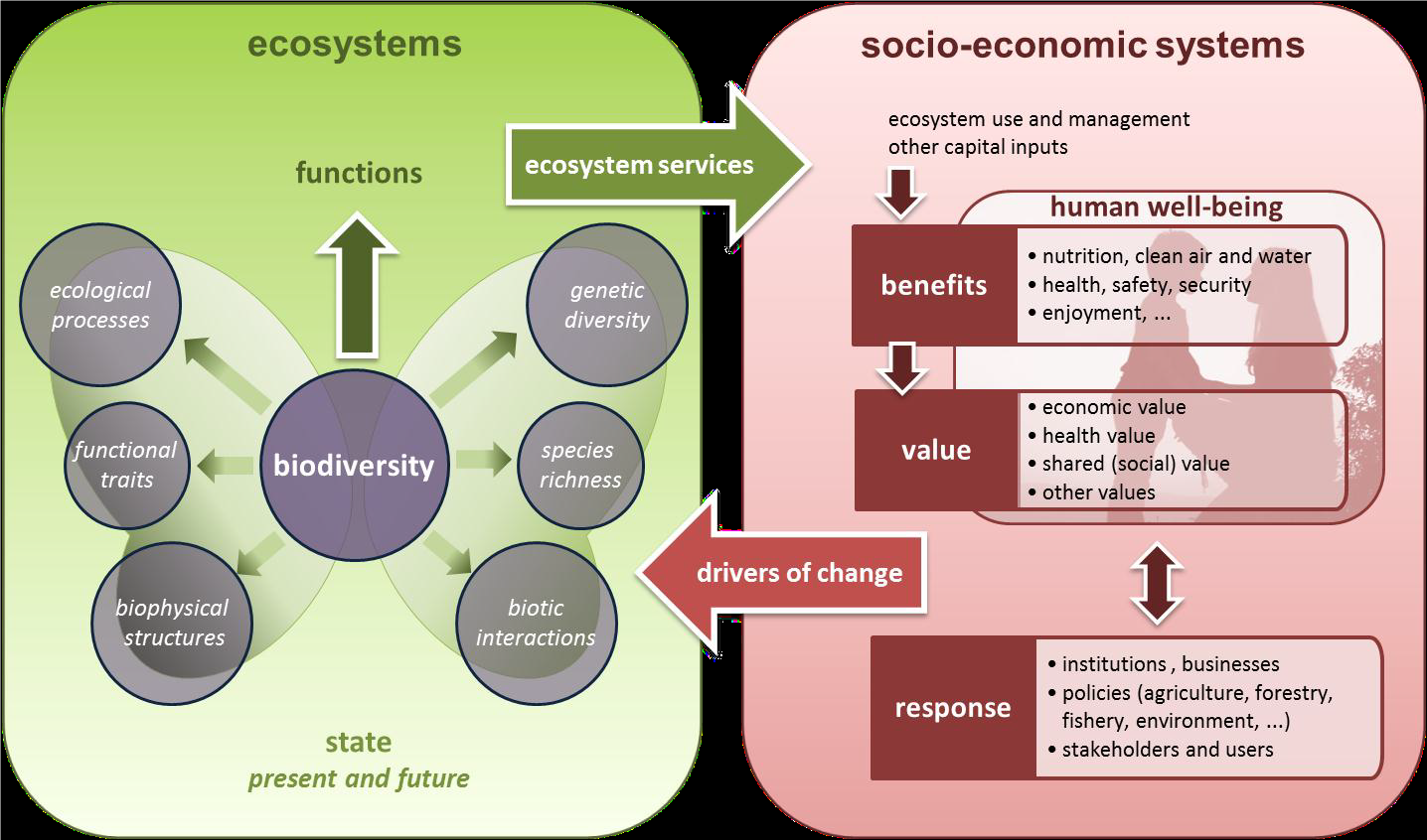
Figure 1 Conceptual framework for EU wide ecosystem assessments that shows how a functioning ecosystem delivers flows of ecosystem services to the socio-economic system, and how the ecosystem are impacted by drivers in the socio-economic system (EU, 2013)
This section will be developed further in 2018. It is intended to present an economic and social analysis of selected sectors (fisheries and aquaculture, shipping, ports, oil and gas industry, and offshore wind energy) using selected indicators (gross value added, employed persons, and development in production value). It is intended to base the analysis on statistical data, using as far as possible the previously mentioned NACE classification. The data will be collected from Contracting Parties in 2018. |
A series of maps are used to describe the spatial distribution and intensity of selected uses: fisheries and aquaculture (Figure 2 and Figure 3), shipping (Figure 4), ports (Figure 5), oil and gas industry (Figure 6), and offshore wind energy (Figure 7). The maps are based on existing OSPAR data streams, and other sources where necessary and as identified. They help identify ‘hotspots’ of certain economic activities, which can be linked to potential environmental pressures. |
Fisheries and aquacultureFisheries operate across the entire OSPAR Maritime Area. Figure 2 illustrates seabed abrasion due to demersal fisheries, as an example of the spatial extent of this activity. Figure 2 does not include pelagic fisheries, as a fishing intensity map was not available for the whole OSPAR Maritime Area, which would show a different spatial pattern. The picture is different for aquaculture, which is not significant on a national scale for most OSPAR countries. The locations of shellfish cultures, finfish farms and general aquaculture site (Figure 3) highlight the differences in their distribution across the OSPAR Maritime Area. Most finfish aquaculture occurs in Norway, Scotland and Ireland, whereas aquaculture for shellfish is more widespread. |
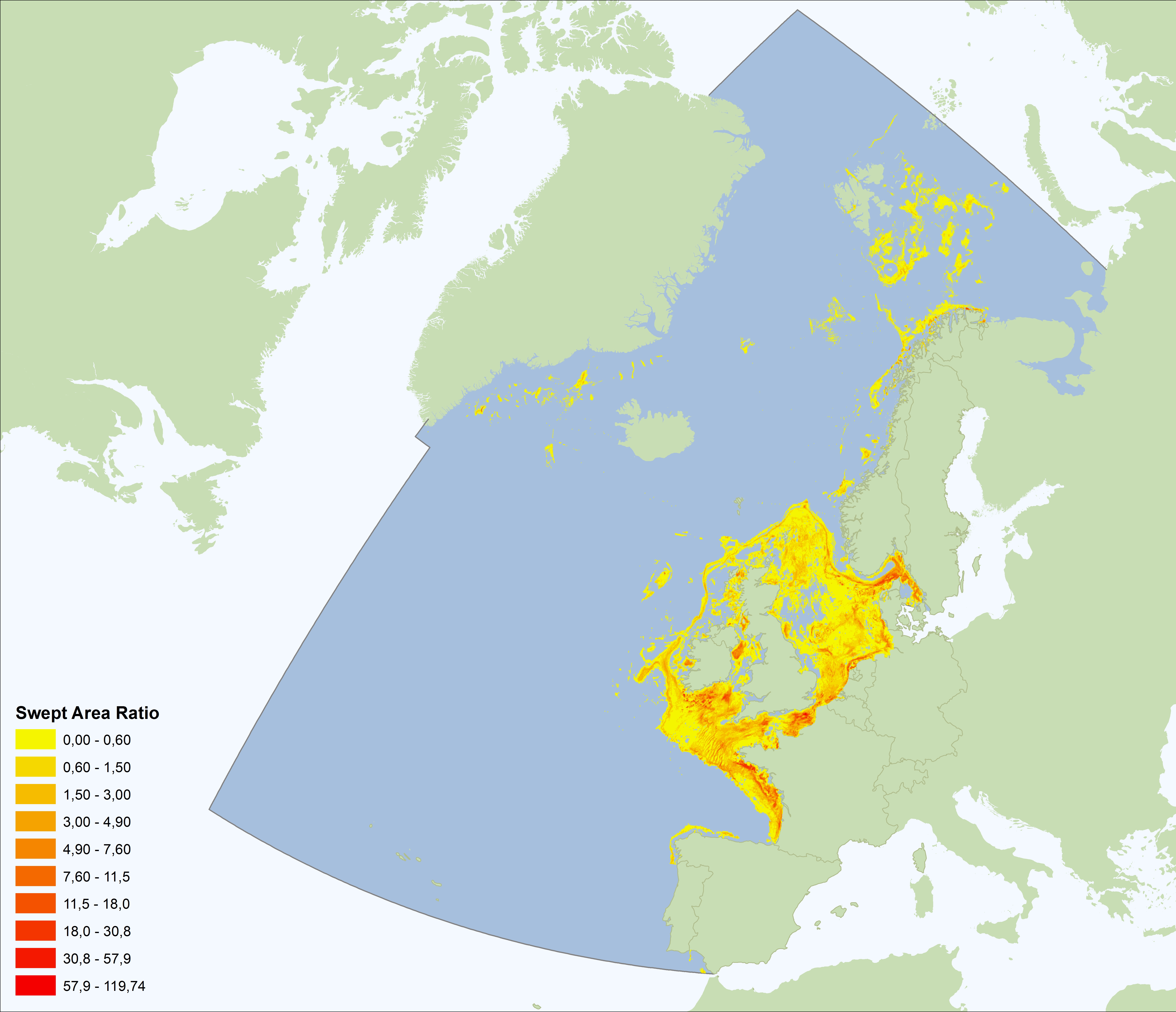
Figure 2: Seabed abrasion from demersal fisheries (2014) (Data Source: OSPAR)
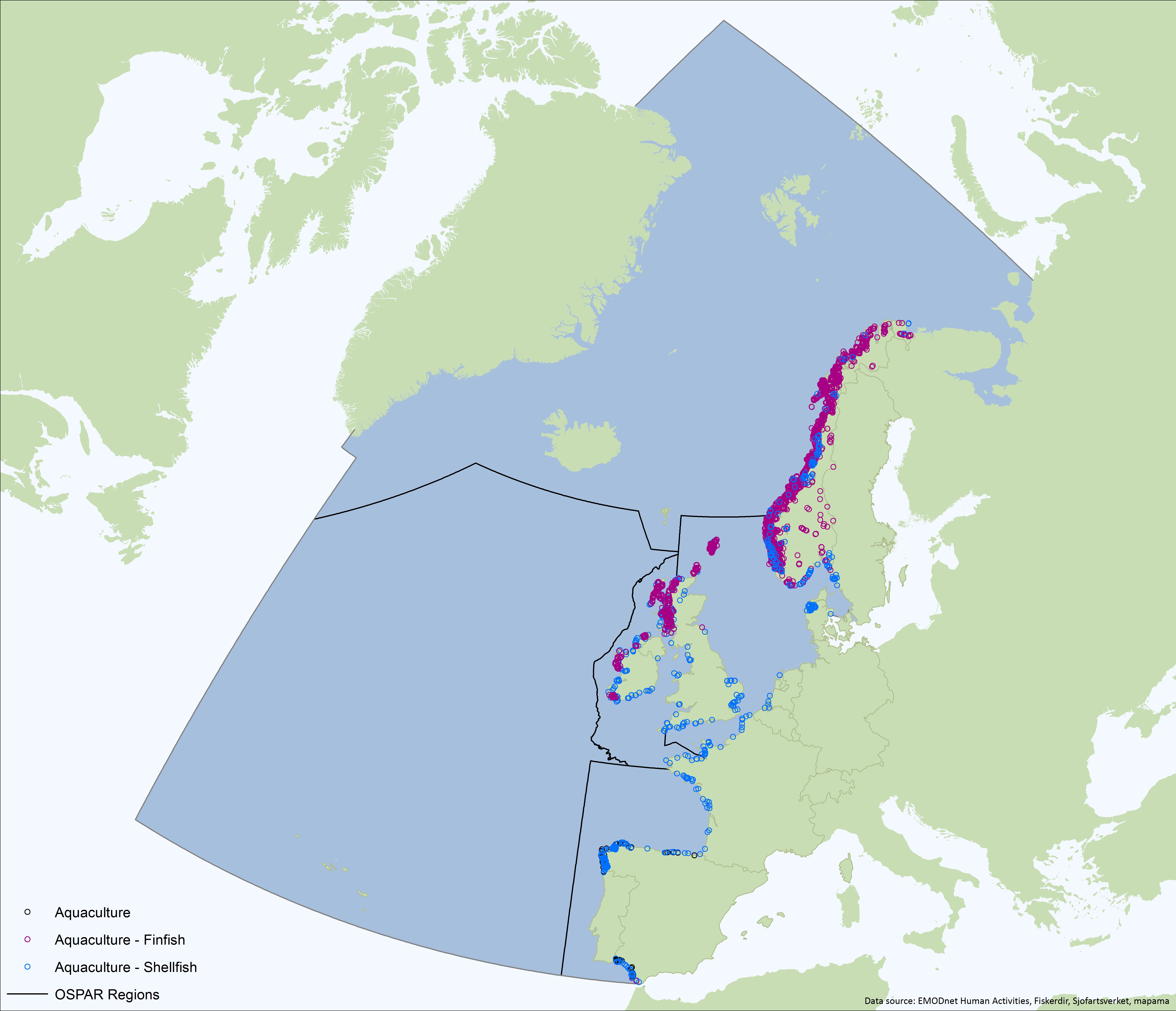
Figure 3: Aquaculture sites in the OSPAR Maritime Area (Data Sources: Bonn Agreement, Norway, Spain, EMODNet Human Activities)
Ports and ShippingThe economic activity related to shipping is widespread throughout the OSPAR Maritime Area although the highest densities of ship traffic are found in the English Channel and the southern North Sea, where the majority of Europe’s largest ports are located (Figure 3.4), and at the entrance to the Mediterranean Sea. There is also support traffic for offshore oil and gas platforms in the North Sea as well as new wind farm developments. The major ports provide a wide range of support services including shipbuilding and maintenance and are widely distributed along the OSPAR coasts (see Figure 5). |
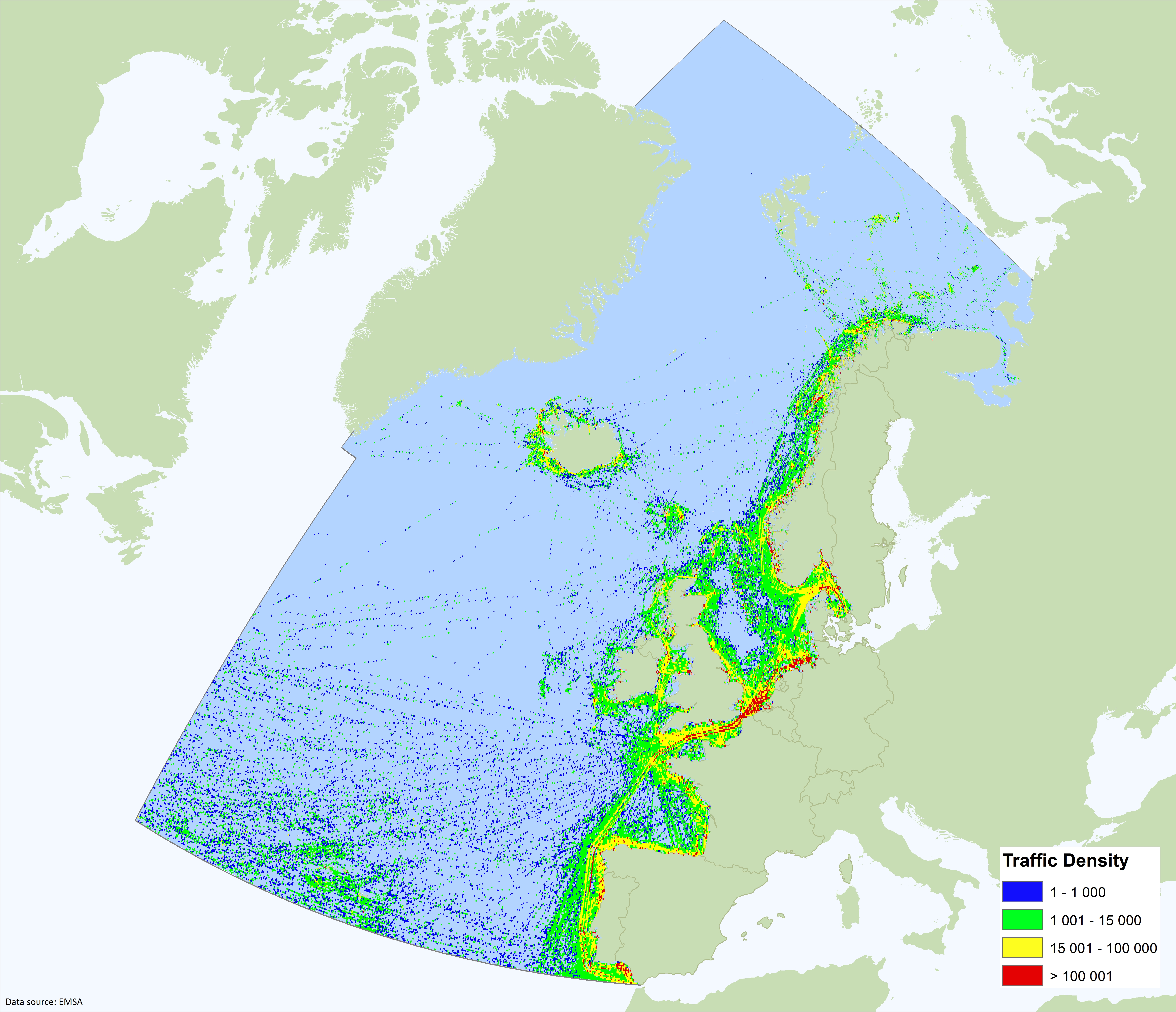
Figure 4: intensity of shipping in OSPAR Maritime Area for 1 week period in February 2017 (Data Source: EMSA)
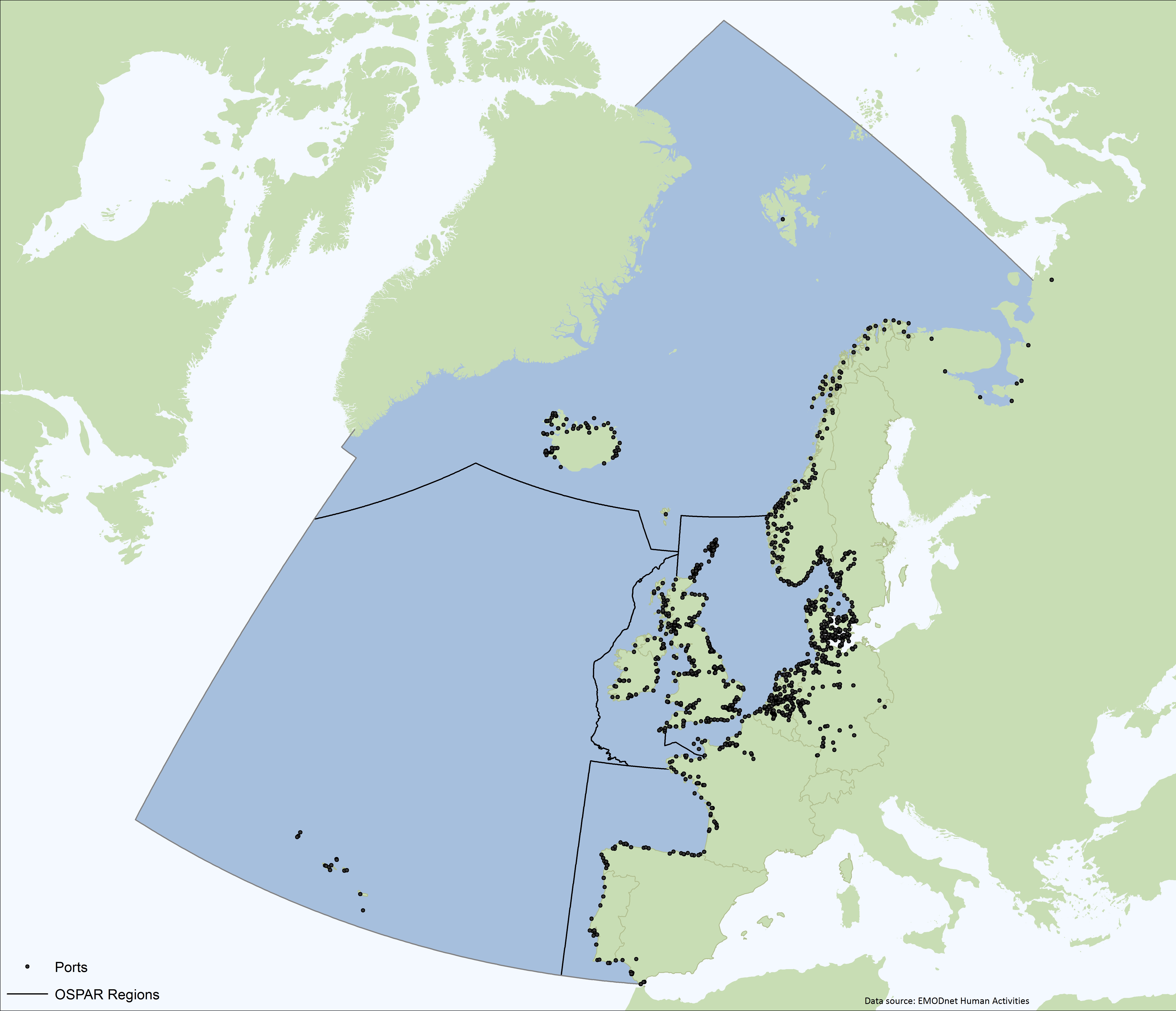
Figure 5: Ports in the OSPAR Area (Data Source: EMODNet Human Activities Portal)
Oil and gasOil and gas exploration takes place in a few OSPAR Contracting Parties, with the United Kingdom, Norway, the Netherlands and Denmark having the majority of offshore installations (Figure 6). For other countries, the number of offshore installations is relatively small. |
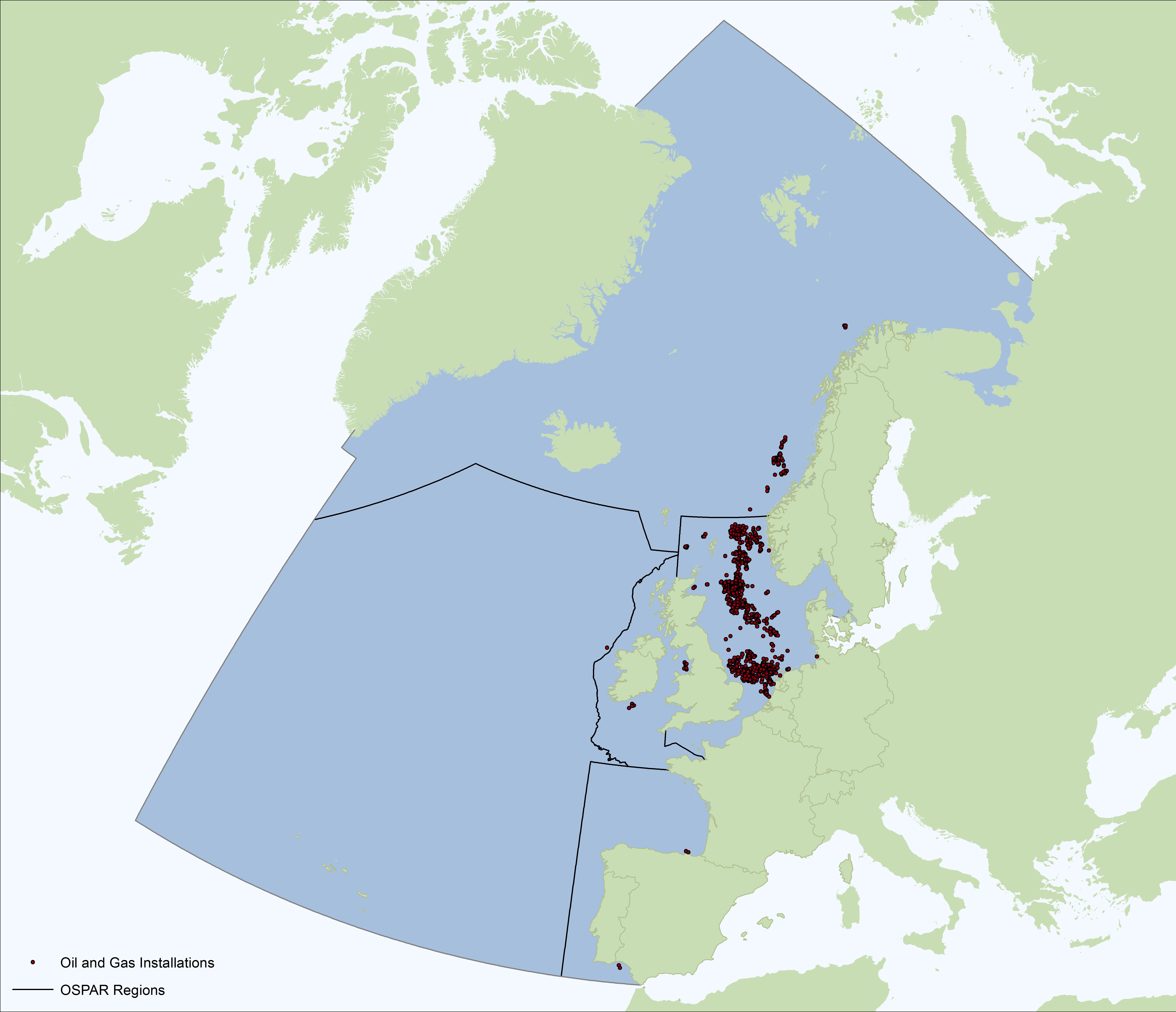
Figure 6: Oil and gas installations in the OSPAR maritime region (Data Source: OSPAR)
|
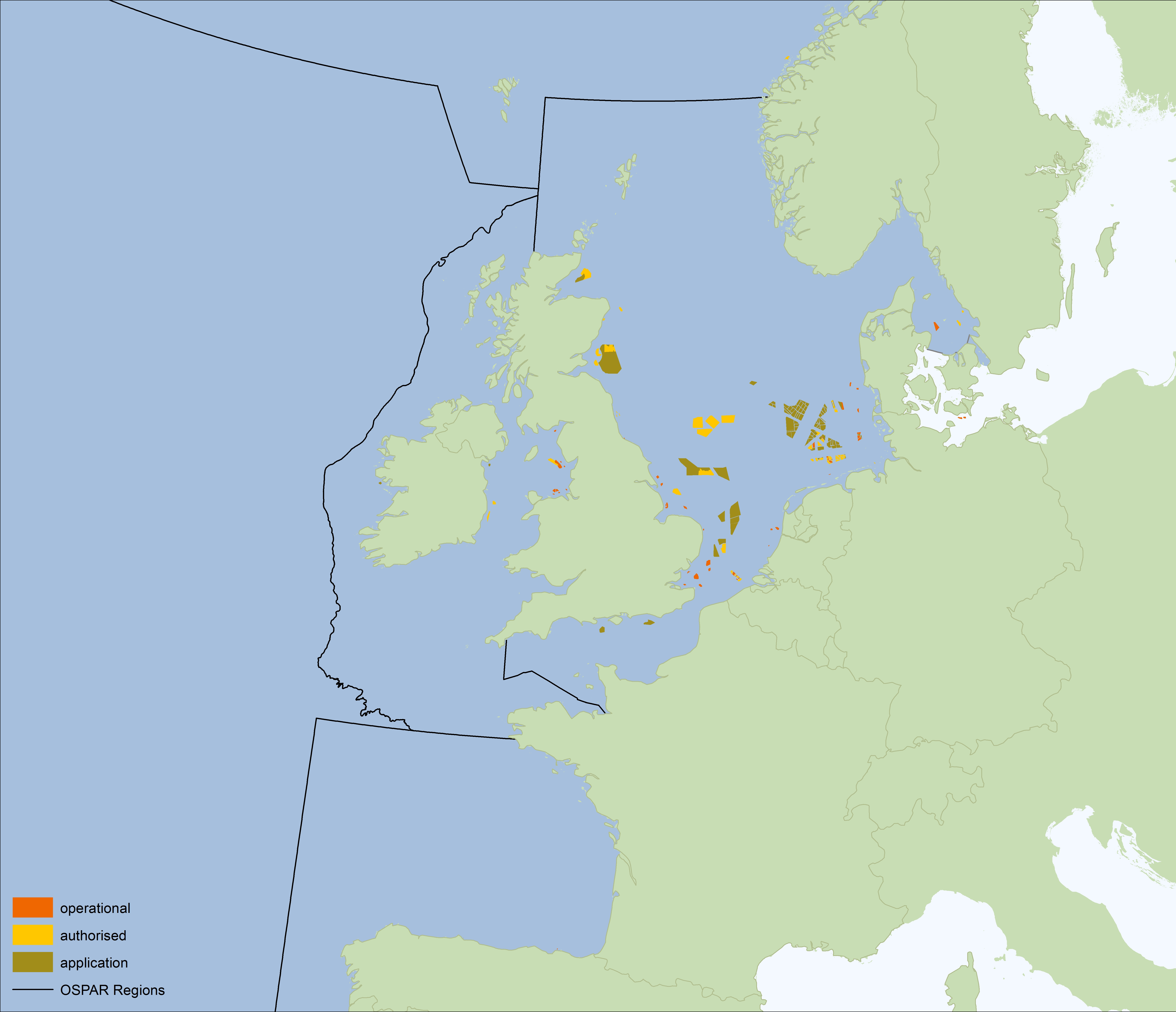
Figure 7: Operational, proposed and planned wind farms in the OSPAR Maritime area (Data Source: OSPAR)
To allow future economic and social analysis of uses of the OSPAR Maritime Area there is a need to:
- quantify the relationship between economic activities and pressures on the marine environment, and determine how these impact the benefits we can derive from the ocean in terms of ecosystem services.
- develop a uniform description of the economic activity ‘recreation and tourism’. This is an important activity both because of the economic relevance and because of its dependency on the marine ecosystem, but since it is not have a separate NACE code, it is not yet possible to collect the relevant data in a uniform manner.
Börger Tobias, Broszeit Stefanie, Ahtiainen Heini, Atkins Jonathan P., Burdon Daryl, Luisetti Tiziana, Murillas Arantza, Oinonen Soile, Paltriguera Lucille, Roberts Louise, Uyarra Maria C., Austen Melanie C. Frontiers in Marine Science, Volume 3, 2016, Pages 192, https://doi.org/10.3389/fmars.2016.00192 B. Grizzetti, D. Lanzanova, C. Liquete, A. Reynaud, A.C. Cardoso, Assessing water ecosystem services for water resource management, Environmental Science & Policy, Volume 61, July 2016, Pages 194-203, ISSN 1462-9011, https://doi.org/10.1016/j.envsci.2016.04.008. |