

Condition of Benthic Habitat Communities: Subtidal Habitats of the Southern North Sea
D1 - Biological Diversity D6 - Seafloor Integrity
D1.6 - Habitat condition D6.2 - Condition of benthic community
Key Message
Benthic habitat community quality has been sub-regionally assessed in terms of species richness in the southern North Sea. Community quality is generally lower in coastal areas than offshore areas and this is partly due to higher fishing pressure in coastal areas.
Area Assessed
Printable Summary
Background
Benthic (seafloor) habitats are essential for marine life because marine species rely directly or indirectly on the seafloor to feed, hide, rest or reproduce. Benthic habitats are characterised by animal and plant communities with no or slow mobility compared to fish or marine mammals. The whole community is therefore exposed when a bottom pressure occurs. As a result, the condition (quality status) of benthic habitats is a reflection of the combined effect of all the pressures put upon it. The number of species corrected for their abundance, is often used to assess the impacts of different pressures (such as disturbance of the seafloor and extraction of species by fisheries, nutrient and organic enrichment, sedimentation and contaminants) on the benthic habitat and community condition.
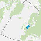
Sub-regional-scale benthos assessments are a relatively new development. However, they build upon 15 years of international marine benthos experience within the framework of the European Union Water Framework Directive (WFD). The southern North Sea includes the waters of Belgium, Denmark, Germany, the Netherlands and the United Kingdom (Figure 1) and can be regarded as a coherent biogeographical zone of mainly subtidal soft sediments. Therefore the southern North Sea was selected for the first application of a common multi-metric index (MMI) for marine benthos.
Several MMIs were tested and the single Margalef diversity index was selected because it is the most pressure sensitive.
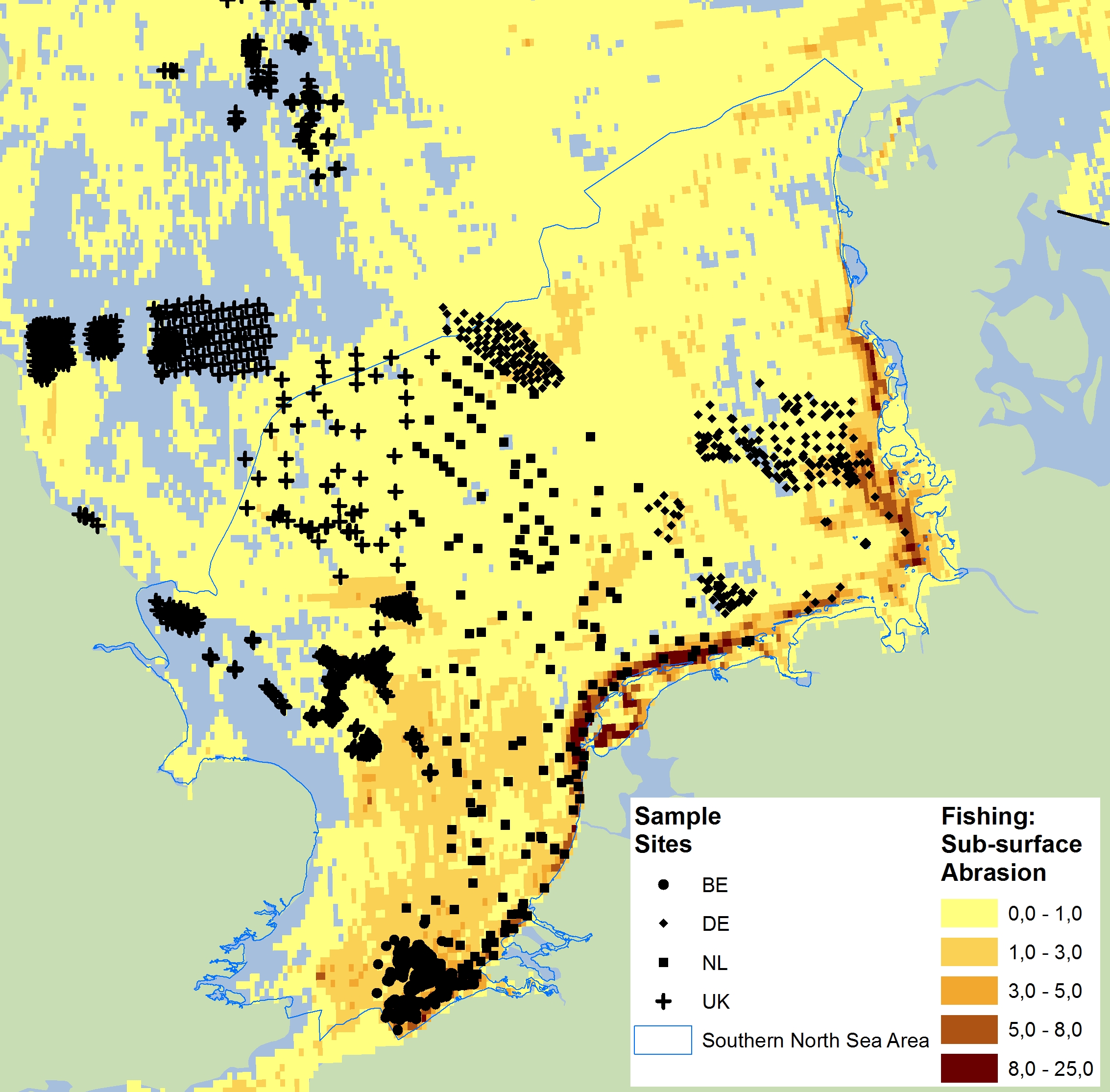
Figure 1: The southern North Sea encompasses the waters of the Belgium, Denmark, Germany, Netherlands, and United Kingdom
Black symbols indicate benthos monitoring samples (no benthos data from Denmark). Yellow/orange shading indicates bottom fishing abrasion in terms of swept area ratio.
The southern North Sea assessment to determine benthic habitat community quality was performed using the well-established Margalef diversity index. This is a biodiversity index which gives the species richness of a sample divided by the logarithm of the total abundance within the same sample. The difference between the Margalef diversity index, which is a method to calculate this biodiversity measure; and Margalef diversity, which is the resulting index score of this method should be noted.
A multi-metric index (MMI) is by definition composed of at least two indices. The principal advantage of using a benthic MMI is that it can be more sensitive and precise than a single benthic index to detect changes in pressures and resulting benthic condition. However, this must be tested for each MMI combined with the relevant benthos and pressure data.
It was shown in this assessment that Margalef diversity effectively corrects for differences in sample size and natural variations in total abundance – and associated species richness – within assessment areas such as the German Dogger Bank - Sandy habitat (see Van Loon et al., 2017). Furthermore, it was demonstrated that the Margalef diversity index is the most sensitive and precise index for measuring the effects of fisheries on benthos (Figure 3); and was also proven to be sensitive for nutrients and / or organic enrichment, sedimentation and heavy metals (Figure a, Figure b and Figure c) (Van Loon et al., 2017).
Reference values of the Margalef diversity index are needed to compare the present benthic condition with the reference condition of a specific assessment area. At this stage, reference values for specific areas reflecting main habitat types were used to ensure full comparability of the reference and assessment data (Figure 2). However, in the future it is intended that there will be habitat-specific reference values. A reference value of a benthic index is defined as the average index value within an assessment area in the pristine state. There are probably no areas in the southern North Sea that are in the pristine state, in view of the widespread fisheries pressure. However, it appeared that Margalef diversity reference values used in this assessment can be further tested as a concept by using available benthos data from less impacted areas or a reference value model (high percentile values and depth) (see Van Loon et al., 2017 for more technical details). A similar reference value estimation method has been commonly applied in European Union Water Framework Directive (WFD) MMIs (see Borja and Tunberg, 2011; Van Hoey et al., 2013; Van Loon et al., 2015). In addition, a new model was developed to predict reference values of Margalef diversity for specific assessment areas, using Depth as an input variable. This model appeared to be sufficiently precise and useful in this assessment.
In the European Union WFD, the sensitivity of the proposed benthos MMI for commonly occurring pressures must be demonstrated. This is an essential step, in order to be confident that the selected benthos MMI will correctly and sensitively respond to changes in common (and local) pressures and resulting benthic condition. Similarly, for this OSPAR / European Union Marine Strategy Framework Directive (MSFD) MMI the pressure sensitivity of the Margalef diversity index for fisheries and nutrients and / or organic enrichment (both common pressures) and sedimentation and heavy metals (local pressures) has been demonstrated (Figure a, Figure b, and Figure c). It was found in the pressure-impact testing that the Margalef diversity and species richness benthic indices in general showed a similar sensitivity and precision. However, the Margalef diversity index appeared to be more suitable for predicting reference values using the depth model described above (Figure d1 and Figure d2), which was decisive in selecting the Margalef diversity index as MMI. In addition, it was found in this assessment that multi-metric combinations of the Margalef diversity index with the species sensitivity indices AZTI Marine Biotic Index (AMBI) and the Infaunal Trophic Index (ITI) did not improve the MMI performance compared to the Margalef diversity index alone. Therefore, for reasons of practicality, only Margalef diversity was used.
For MMI optimisation and routine assessments, the availability of a correct, transparent and efficient data analysis tool is important. Therefore, a tailor-made benthos data analysis tool was developed and used for this assessment, the so-called BENMMI (Benthos MMI). This tool is fully operational and is routinely used by several of the southern North Sea countries (see Walvoort and Van Loon, 2016).
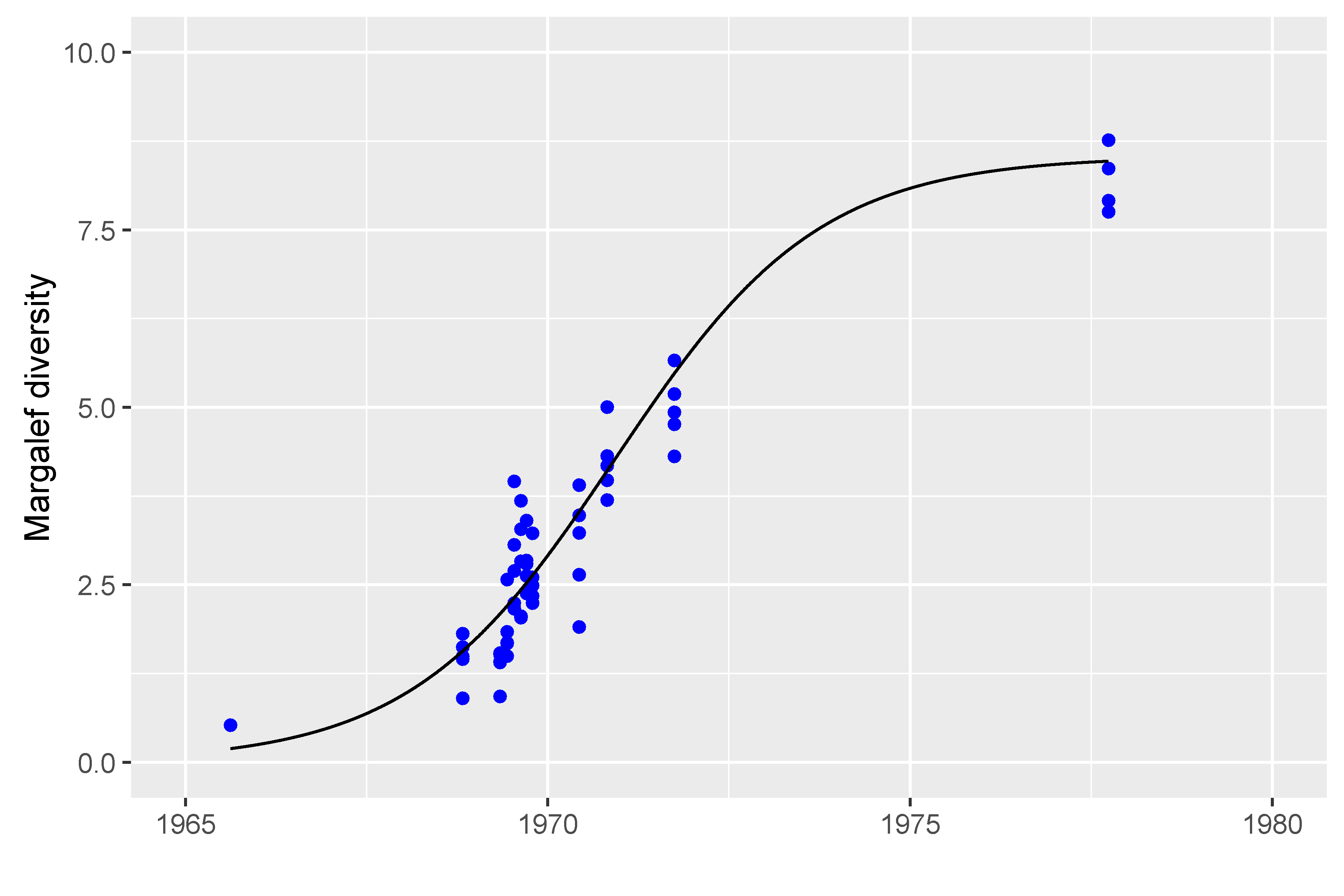
Figure a: Relation between decreasing nutrients and / or organic enrichment (organic enrichment due to pulp mill effluent) and the Margalef diversity index value (R2 = 0.90) in the Swedish Saltkalle fjord which flows into the Northern North Sea
Note that the pulp mill closed in 1966, and that the recovery of the benthos over time due to the decreasing amounts of organic matter on the benthic habitat is visible as an increasing Margalef diversity value.
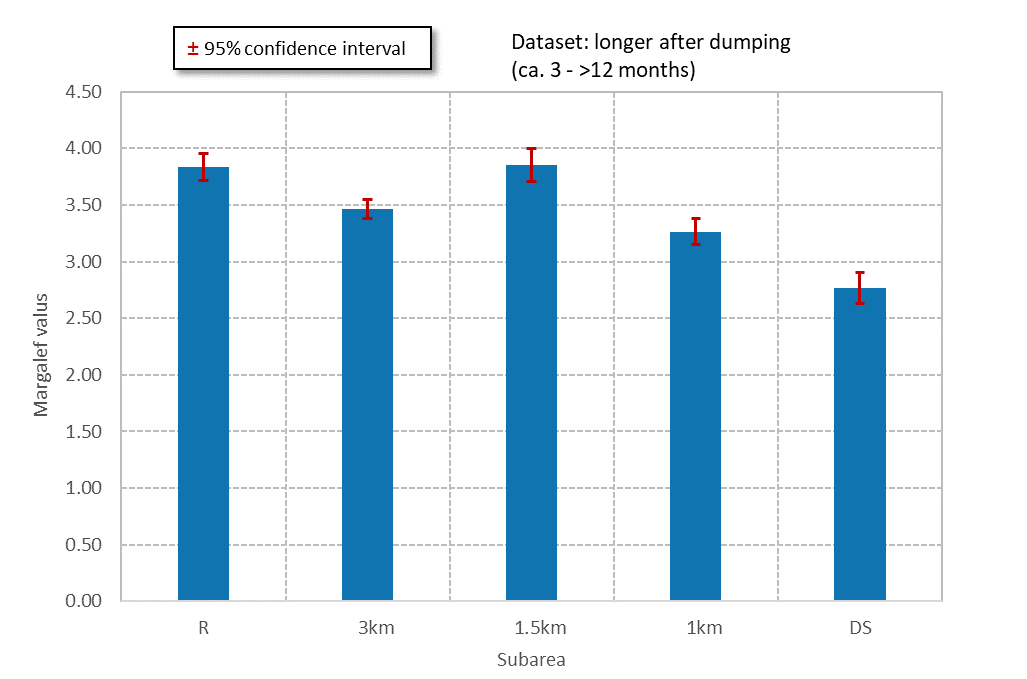
Figure b: Relation between distance of benthos from a German dump site (DS) near Heligoland, and benthic condition as measured by Margalef diversity
Three circular areas around the dump site (1 km, 1.5 km, 3 km) and a reference site at greater distance, unaffected by the dumpsite, were investigated for benthic condition. Significant effects of sediment dumping and sedimentation on the benthos are observed at the dump site and in the 1 km zone.
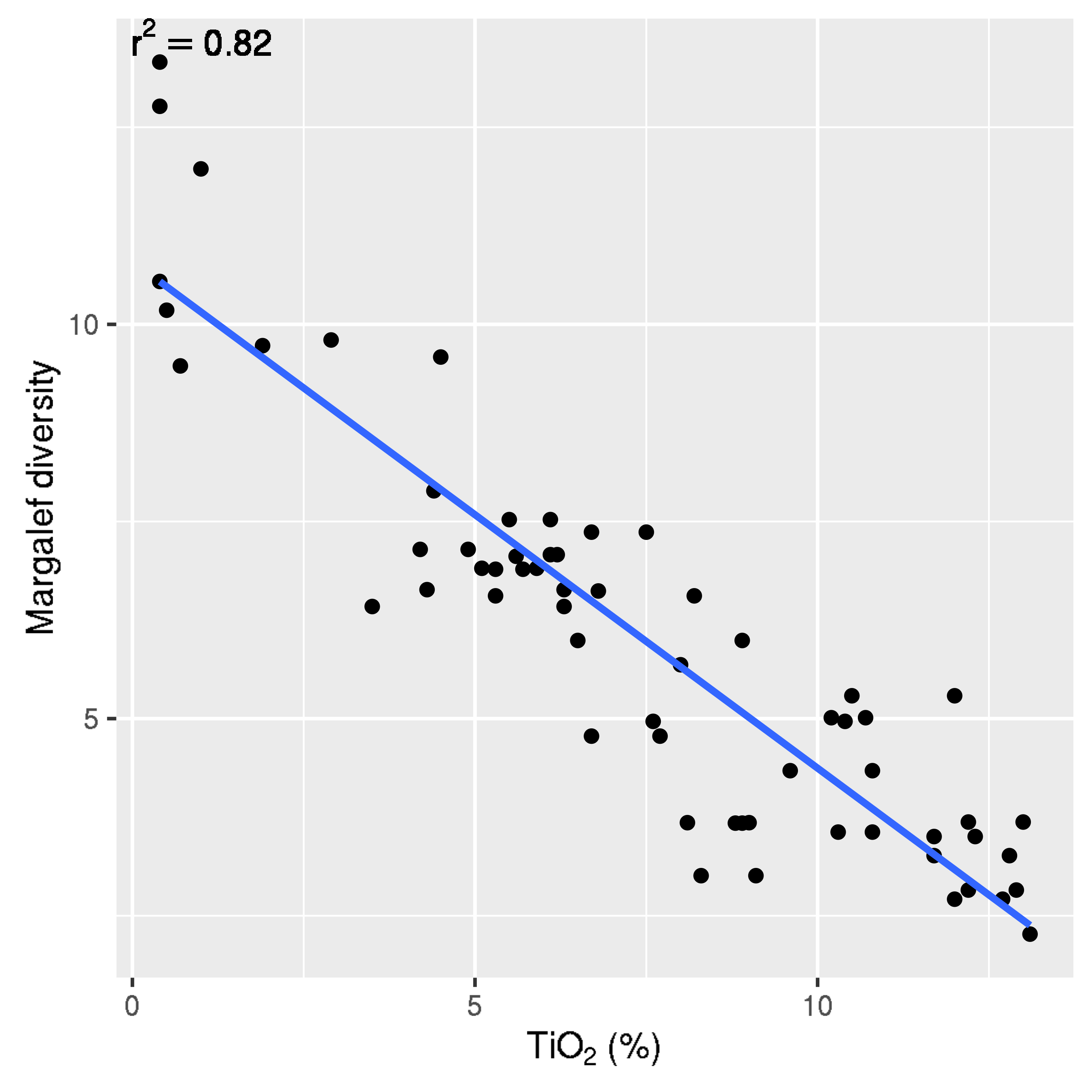
Figure c: Relation between titanium dioxide (TiO2) concentration in sediment and benthic condition in the Norwegian Jossing fjord entering the Northern North Sea, as demonstrated using Margalef diversity
The observed relation is highly significant, as visible in the high R2 value (0.82).
It should be noted that in coastal areas in the theoretical reference (pristine) state, reference values for Margalef diversity are lower than in deeper offshore areas due to higher natural pressures in the coastal zone (wave and occasional storm action, stronger currents).
To have a fully defined assessment process and assessment results, a benthic assessment in generally requires the definition of the following aspects: geographic area and period to be assessed; careful selection of suitable benthos datasets; availability of a pressure-validated, sensitive and precise multi-metric index (MMI); an index reference value estimation and validation method; and a well characterised and documented technical assessment, performed using a correct and efficient assessment tool. The five steps are described in more detail below.
Geographic Area and Period Assessed
The southern North Sea (Figure 1), outside the European Union Water Framework Directive (WFD) one nautical mile zone, was assessed with the Margalef diversity index.
The Belgium part of the area assessed, shown in the bottom of Figure 1, contains one area (North Sea) and two habitats (sand and coarse). These two habitats occur alternately as sand banks and gulleys. The German part of the area assessed, is in the north-east part of the southern North Sea: the coastal zone, the Borkum Reef Ground (south part), the Elbe Urstrom Valley (centre part), the Sylt Outer Reef (north part) and Dogger Bank (north-west part). The Dutch part of the area assessed, is in the centre part of the southern North Sea and contains the coastal zone, the offshore area (south part), the Frysian front (north-east part), the Oyster banks (north part) and the Dogger bank (north-west part). The UK part in the west part of the southern North Sea contain: Farnes East, North East of Farnes Deep, Swallow sand, Holderness offshore (near the UK coast), Markhams triangle (against the border with the Dutch area), north Norfolk Sandbanks (centre of UK part of southern North Sea).
The assessment period was 2010–2015, which was synchronised with the period used for the indicator assessment of Extent of Physical Damage to Predominant and Special Habitats .
Datasets
Benthos data were supplied by Belgium, Germany, the Netherlands and the United Kingdom, and processed by the Netherlands. For Belgium, Germany and the Netherlands it was assessed, based on expert judgement, that full areal coverage was obtained, for the United Kingdom it was assessed to be partial areal coverage, and no data from Denmark were available. A criterion for sufficient areal coverage had not been discussed and agreed at the time of writing but will be part of the further development of this indicator assessment. For the United Kingdom, some benthos data from assessment areas lying just north of the southern North Sea were assessed (Farnes East, North-East of Farnes Deep, Swallow Sand), in view of the limited data available. The assessment areas were combined with European Nature Information System (EUNIS) Level 3 habitat information (Sand, Mud, Coarse, Mixed), based on an average of 30 samples per area, per year. In addition, median depth data were collected for additional characterisation of the assessment area and reference value modelling. A more detailed characterisation of these data was given by Van Loon et al. (2017, Table 1).
Fisheries activity maps from the International Council for the Exploration of the Sea (ICES; surface and sub-surface activity per grid cell of 0.05° × 0.05°) version January 2016 were used (Figure 1 for an example)(ICES, 2016). The ICES grid cell activity values were averaged per assessment area, for surface and sub-surface activity separately, in order to average out the spatial variation sufficiently, which improved the pressure-impact relationship considerably. It should be noted that the disturbance values being used for the assessment of physical damage on special and predominant habitats were not used for this assessment, but that the same abrasion pressure layer, derived from the ICES fisheries data, was used.
Index Calculation
The optimal benthic index for the southern North Sea, Margalef diversity, was calculated for all southern North Sea benthos samples using the BENMMI tool (benthos multi-metric data analysis software). For each assessment area, the annual average normalised value of Margalef diversity was calculated. The normalised index value is the Margalef diversity value of a sample divided by the reference value of Margalef diversity for the specific assessment area where the sample was taken. It should be noted that Margalef reference values are obtained using reference data from the North Sea (where available) or modelled reference values using least disturbed benthos data monitored by the same national laboratory. This favours good comparability of the reference and assessment Margalef diversity values.
Reference Value Estimation and Validation
An important step in getting realistic normalised Margalef diversity values is to estimate realistic Margalef diversity reference values for each assessment area, such as for the UK_SwallowSand-Sandy habitat. This was done by calculating the 99 (or in some case 95 and 75) percentile index value of a sufficiently large set of Margalef diversity values (with a minimum of 20) for the specific assessment area, as has been used for the European Union WFD by several countries (Van Loon et al., 2015). The use of the 99 or 95 percentile value as the average reference value accounts for a certain amount of index degradation. However, this percentile method was refined by allowing the use of lower percentile values, in case of lower assessment area degradation, as published by Hering et al. (2006). For example, in a pristine assessment area the 50 percentile Margalef diversity value would be the correct reference value. This estimation of lower assessment area degradation could be made using the fisheries activity data from ICES (2016) (see Datasets).
The following quality codes were assigned to the benthos datasets per assessment area: quality code 1 (one monitoring year and at least 20 samples); quality code 2: (two monitoring years and 30 or more samples); quality code 3: (three or more monitoring years and 50 or more samples) (Van Loon et al., 2017. Note that only estimated reference values with quality codes 2 and 3 were used for the Depth-Reference_Value model.
The reference period used per assessment area was in principle six consecutive years, in which the highest period average of the annual average value of Margalef diversity was found. This means that the least disturbed benthos dataset per assessment area is used, as recommended in the OSPAR manual on Biodiversity (OSPAR, 2012). The use of a six-year period appears to give stable reference values, in which temporal variation has been averaged out.
The obtained reference value estimates were validated using the depth model for Margalef diversity (Figure d1; Van Loon et al., 2017), and in some case corrected for better fit on this curve using an adjusted percentile value based on the available fisheries activity data. All Margalef diversity reference values showed a deviation of less than 10% from the depth model, which was considered useful precision.
Assessment of the Southern North Sea
The period average (2010–2015) of the normalised index values of Margalef diversity for each assessment area with at least 20 samples and one monitoring year are shown in Figure 2. The precision of the annual average normalised Margalef diversity (Dn) value per assessment area was calculated as the 90% confidence interval.
Results
The Margalef diversity index shows that in the shallow coastal areas of Belgium, Germany and the Netherlands a relatively lower benthic condition is generally observed compared to deeper offshore areas (Figure 2). The assessment result shows that, in spite of lower coastal reference values, the normalised Margalef diversity values (defined as sample index values divided by the reference value) in the Belgian, German and Dutch coastal areas are generally lower compared to the offshore areas (such as the German and Dutch Dogger Bank). The areas of the southern North Sea assessed (shown in Figure 2) are based on the EUNIS 3 habitat classification system. Each habitat type has been assessed separately.
For the first time, the normalised Margalef diversity value (range 0–1) can be significantly related at a broad international scale to average fishing pressure in the assessment areas of the southern North Sea (Figure 3). In Figure 3, the curve shows an exponential decrease in the benthic habitat community condition in the fisheries activity range 0–2.3 subsurface sweeps / year, followed by a stabilisation of the community condition at higher fishing activities. This curve shows that at a fishing activity of >2.3 subsurface sweeps / year a resilient benthic community of lower quality has been induced, which remains at the same quality level under increasing fishing activity. Note that fishing activity has been averaged per assessment area-year to obtain an improved curve. The 90% confidence interval for each data point (assessment area-year) is shown. The relation is highly significant (p < 0.0001).
This fishing activity is generally relatively high in coastal areas (Figure 1) and relatively low in the Dogger Bank areas. The Dogger Bank extends from the eastern part of British waters to the northern Dutch and German waters. In summary, the normalised Margalef diversity index shows clear differences in benthic community quality between the assessment areas in the southern North Sea (Figure 2).
The results of this assessment describe the impact of fisheries on benthic habitats. However, other human pressures in the coastal zone, such as nutrients and / or organic enrichment , dumping and sedimentation, coastal sand nourishment (at the shoreline), sand extraction and contaminants can also add to the coastal pressure mix on habitats, depending on the local conditions. Of these typically coastal pressures, only nutrients and / or organic enrichment may be present at a wider scale, while the other pressures generally act on a more local scale.
There is moderate confidence in the method for this assessment and high / moderate confidence for data availability.
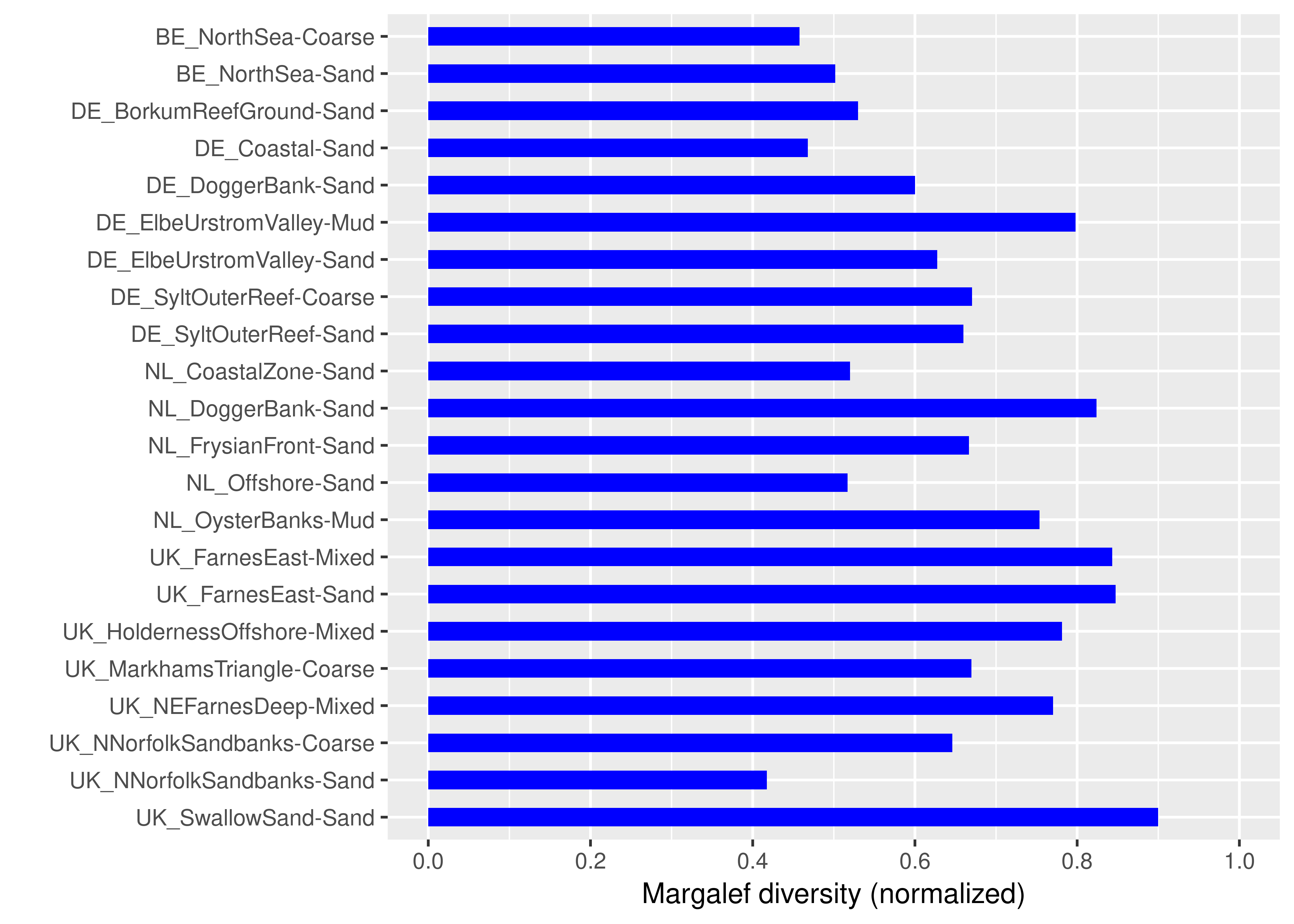
Figure 2: Assessment results for the southern North Sea assessment areas (habitat types) using the normalised Margalef diversity scores (range 0–1) averaged for the period 2010–2015
Note that higher index scores indicate a higher benthic community quality.
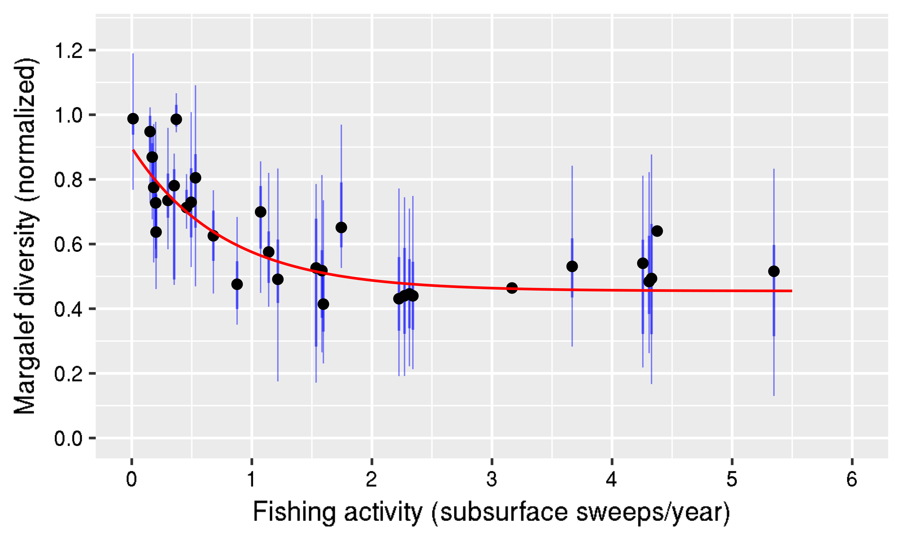
Figure 3: Relation between fishing activity (subsurface) and the normalised Margalef diversity value
Demonstrated for all benthos data from the Southern North Sea in the period 2009–2013 from assessment areas with sufficiently reliable reference values
The Margalef diversity index gives the species richness of a sample divided by the logarithm of the total benthic abundance within the same sample. Consequently, this index is more robust for the differences in sample size, which occur in this international assessment (such as grab samplers and box cores used). In addition, it was demonstrated that there is a clear linear relation between the natural logarithm of the total abundance and species richness for single samples within a single survey of a specific area-habitat (Van Loon et al., 2017). This means that Margalef diversity actually corrects for natural variations in species richness in a monitoring survey in a specific assessment area, apparently caused by differences in total abundance within the same assessment area, and in that way produces more precise index values than species richness. As a result, Margalef diversity produces more comparable reference values, which can be related well with median depth (Figure d1). In contrast, the reference values of species richness in the southern North Sea show much more variation due to the differences in sample size and natural variation within a specific assessment area, and can be modelled poorly (Figure d2). This was the deciding factor in selecting the Margalef diversity index for this assessment.
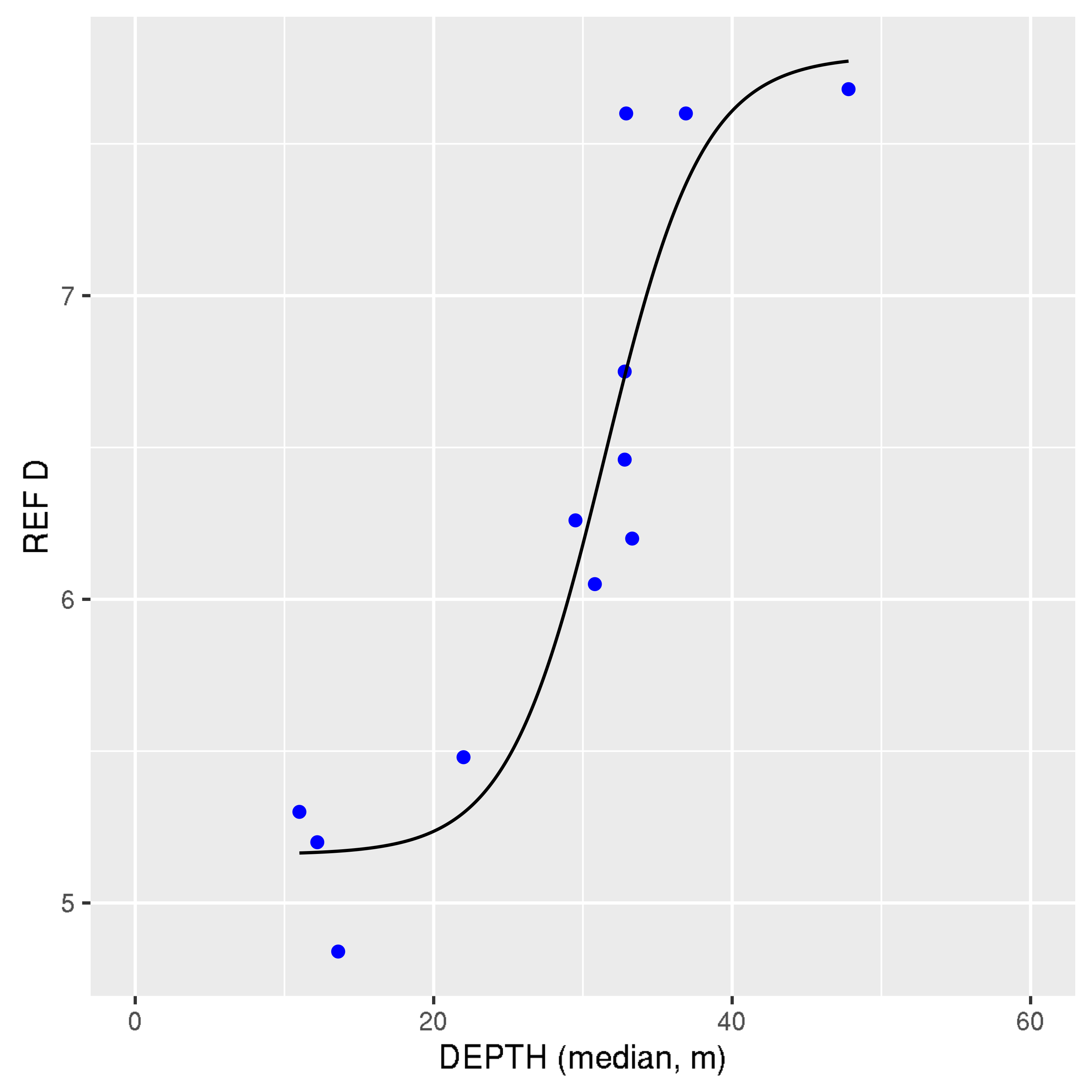
Figure d1: Relation between median depth and the estimated reference value (REF) of Margalef diversity (D) using national benthos datasets (with sufficient amounts of data) within the southern North Sea sub-region.
The precision of this model is good (R2 = 0.86). Note that this model is more precise than for species richness (see Figure d2).
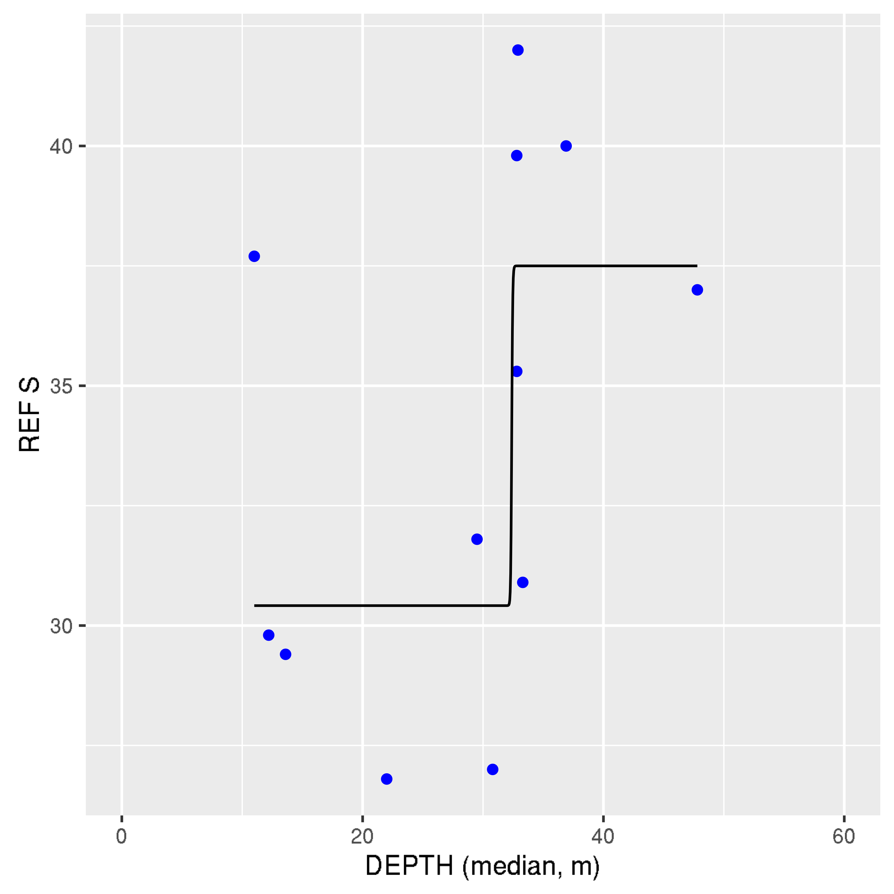
Figure d2: Relation between median depth and the estimated reference value (REF) of species richness (S) using national benthos datasets (with sufficient amounts of data) within the southern North Sea sub-region.
The precision of this model (R2 = 0.48) is much lower than for Margalef diversity (see Figure d1).
It appears from this model that depth is the dominating habitat factor for Margalef diversity. Depth is related to many environmental variables such as natural physical pressures (currents, waves, storms) and consequently sediment composition, natural light limitation, and human fisheries pressures. This model could be confirmed using information from the peer-reviewed literature. This model was very useful to check the reference values of Margalef diversity obtained via another method. In addition, it should also be noted that this model is primarily applicable to predominant habitats that do not have hard substrate structures, such as biogenic reefs. The Margalef reference value model has not been calibrated to apply to habitats containing hard substrate structures, and may therefore underestimate the reference values in these more diverse habitats.
The benthos multi-metric data analysis software (BENMMI), that was specially developed for the purpose of OSPAR / European Union Marine Strategy Framework Directive benthos multi-metric index (MMI) optimisation and routine analyses, appeared to work efficiently and effectively as tested by most countries in the southern North Sea sub-region. This software has resulted in the use of a standardised benthos data format within this region, and produces extensive and standardised data analysis reports, which are very useful as documentation for reporting and quality control. Several new functions, including monitoring precision and power analyses, were included in this tool based on emerging needs during the OSPAR condition of benthic habitat indicator development process. This tool (developed in the statistical programming language R) will be maintained and adapted for future needs, and will be available in 2017 at https://cran.r-project.org/web/packages/BENMMI/index.html. In principle, this tool is also suitable for application in the other OSPAR sub-regions. Suitability must be checked by testing benthos and pressure data from the specific sub-region, and some modifications of the BENMMI tool may be needed.
On average, the 90% confidence intervals of the assessment results were: Belgium ±0.047; Germany ±0.111; Netherlands ±0.055; United Kingdom ±0.053. First analysis shows that a proposed minimum precision of ±0.06, can be met in most cases. This value is still under discussion.
The proposed precision should be reached for each assessment area. It should also be noted that this precision criterion does not reflect the benthic condition of the specific assessment area, but only the precision with which this benthic condition can be assessed.
Assessment of Confidence
This method builds further on common European Union Water Framework Directive (WFD) methodology and has been tested extensively with a large amount of southern North Sea benthos and pressure data. However this is the first time it has been assessed on the regional scale, the results of which have been submitted for scientific publication, therefore the confidence in the method is moderate.
The benthos data availability is generally spatially and temporally sufficient for the assessment, but for some areas was spatially limited and so has been rated high / moderate.
Conclusion
This assessment has focused on the assessment of Condition of Benthic Habitat Communities - Subtidal Habitats of the Southern North Sea as one component of a more comprehensive indicator of the condition of benthic habitats defining communities ( Condition of Benthic Habitat Communities ).
The selected Margalef diversity index assessed the benthic community quality and shows clear differences between assessment areas. Coastal areas usually showed lower benthic quality (reduced Margalef diversity compared to reference values), partly due to relatively high fishing activity. Offshore areas, especially those with greater depth, had relatively higher or high Margalef diversity per sample compared to reference values.
This diversity index appears to be the most sensitive benthic index for indicating differences in impacts of fisheries pressures on benthic community condition in the areas assessed. This index was also the most sensitive benthic index to indicate anthropogenic nutrient and / or organic enrichment, sedimentation and heavy metal pressures in the areas assessed.
This is the first time that an international diversity index has been applied on such a broad geographic scale (across four countries). This method and the corresponding tailor-made software showed good results. This method could also be applicable to other OSPAR sub-regions in the next assessment.
The methods to estimate reference values of Margalef diversity for specific assessment areas (using the variable percentile method), and to validate them (using the new depth model), appear to work well in the southern North Sea. Margalef diversity reference values showed a much better relation with Depth than species richness reference values, which was the decisive factor for selecting Margalef diversity as an index for the southern North Sea.
A sufficient amount of benthos data could be collected to perform an assessment for the period 2010–2015. However, Danish benthos data were lacking at the time of the assessment, and for United Kingdom greater areal coverage in the southern North Sea with benthos data is probably needed.
The fisheries activity data from the International Council for the Exploration of the Sea (ICES) appeared to be useful for the pressure-impact sensitivity testing of the candidate benthic indexes and for assisting in the reference value estimation for Margalef diversity.
It is recommended to use a minimum benthos sampling frequency of twice per six-year European Union Marine Strategy Framework Directive period, in order to be able to average out temporal benthos variation sufficiently.
Tailor-made benthos multi-metric index data analysis software has been developed and appears to be efficient, effective and transparent for performing the Margalef diversity calculations for the southern North Sea assessment. The software can be extended with other benthic indexes and used in other OSPAR sub-regions as required.
There are several apparently high-quality benthos designated Marine Protected Areas in UK waters (Farnes East, north-east of Farnes Deep, Swallow Sand), which could be useful for further investigation of high quality North Sea benthic habitats. The German and Dutch Dogger Bank also shows a relatively high benthic condition.
Knowledge Gaps
Margalef diversity reference values for assessment areas appeared to be well related to the important environmental variable depth. Depth is an important driver for a suite of habitat variables, including sediment composition. However, reference values may still be improved by explicitly incorporating sediment type within the model.
An assessment value for the Margalef diversity index score needs to be developed. It may also be useful to differentiate this assessment value for specific assessment areas. Further consideration of benthos data availability across the OSPAR Maritime Area is also needed for wider application of the indicator in the future.
A criterion for sufficient areal coverage of benthos sampling will be discussed within the OSPAR benthic habitat expert group in the near future. A coordinated monitoring programme across OSPAR countries for collecting a sufficient amount of benthos data is also needed.
The relationship between Condition of Benthic Habitat Communities and Extent of Physical Damage to Predominant and Special Habitats results should be investigated further.
Although it was not considered a problem in this assessment, it is recommended to check the harmonization of the taxonomic level of detail of different laboratories in the southern North Sea.
Assessment precision results for the southern North Sea are available and could be used to define a minimum required precision for the Margalef diversity method.
Borja, A., Tunberg, B.G., 2011. Assessing benthic health in stressed subtropical estuaries, eastern Florida, USA using AMBI and M-AMBI. Ecol. Indic. 11, 295–303.
D. Hering, C.K. Feld, O. Moog and T. Ofenbock, 2006. Cook book for the development of a Multimetric Index for biological condition of aquatic ecosystems: experiences from the European AQEM and STAR. Hydrobiologia (2006) 566:311–324.
D.W.W. Walvoort and W.M.G.M. van Loon, 2016. BENMMI user manual. http://publicaties.minienm.nl/documenten/user-manual-benmmi-3-0.
ICES 2016. Updated ICES fisheries GIS maps version jan 2016. Available from: http://ecosystemdata.ices.dk/download/ OSPAR_mapping_bottom_fishing_intensity_data_outputs_2015.zip
OSPAR, 2012. MSFD Advice Manual and Background Document on Biodiversity. Version 3.2.
Van Hoey, G., Permuy, D. C., Vandendriessche, S., Vincx, M., & Hostens, K. (2013). An ecological quality status assessment procedure for soft-sediment benthic habitats: weighing alternative approaches. Ecological Indicators, 25, 266-278.
W.M.G.M. van Loon, A.R. Boon, A. Gittenberger, D.J.J. Walvoort, M. Lavaleye, G.C.A. Duineveld, A.J. Verschoor, Application of the Benthic Ecosystem Quality Index 2 to benthos in Dutch transitional and coastal waters, Journal of Sea Research, Volume 103, September 2015, Pages 1-13, ISSN 1385-1101, http://dx.doi.org/10.1016/j.seares.2015.05.002.
W. van Loon, D. Walvoort, M. Lavaleye, G. Duineveld, G. van Hoey, A. Blandon, C. Herbon, G. Philips, R. Pesch, P. Schmitt, J. Scholle, K. Heyer, M. Blomqvist, 2017. Multi-Metric Index assessment of benthos in the southern North Sea using Margalef D, submitted for publication.
Willem van Loon, Dennis Walvoort, Gert van Hoey, Christina Vina-Herbon, Abigayil Blandon, Roland Pesch, Petra Schmidt, Jorg Scholle, Karin Heyer, Marc Lavaleye, Graham Philips, Gerard Duineveld, Mats Blomqvist, 2017. A regional benthos assessment method for the southern North Sea using Margalef diversity and reference value modelling.
| Sheet reference | BDC17/D116 |
|---|---|
| Assessment type | Intermediate Assessment |
| Context (1) | Biological Diversity and Ecosystems - Targeted actions for the protection and conservation of species, habitats and ecosystem processes |
| Context (2) | OSPAR Agreement 2014-02 OSPAR Joint Assessment and Monitoring Programme (JAMP) 2014 – 2021. Update 2015 |
| Context (3) | D1 - Biological Diversity, D6 - Seafloor Integrity |
| Context (4) | D1.6 - Habitat Condition, D6.2 - Condition of benthic community |
| Point of contact | OSPAR Secretariat |
secretariat@ospar.org | |
| Metadata date | 2016-08-26 |
| Title | Condition of Benthic Habitat Communities : Subtidal Habitats of the Southern North Sea |
| Resource abstract | The Southern North Sea has been assessed with the Margalef D diversity index, used as a common multi-metric index for OSPAR and MSFD. This index is sensitive for fisheries, nutrients and/or organic enrichment, sedimentation, and heavy metals. An automated tool was developed for routine assessments. |
| Linkage | http://www.ospar.org/documents?d=32988 |
| Topic category | Environment |
| Indirect spatial reference | L3.2.5.28 |
| N Lat | 57.3475216749854 |
| E Lon | 8.33360761689806 |
| S Lat | 51.0982649186911 |
| W Lon | 0.164464855668598 |
| Countries | BE, DE, NL, UK |
| Start date | 2009-01-01 |
| End date | 2013-12-31 |
| Conditions applying to access and use | https://www.ospar.org/site/assets/files/1215/ospar_data_conditions_of_use.pdf |
| Data Snapshot | https://odims.ospar.org/documents/189/download |
| Data Results | https://odims.ospar.org/documents/190/download |