

Condition of Benthic Habitat Communities: Subtidal Habitats of the Southern North Sea
D1 - Diversité Biologique D6 - Intégrité des fonds marins
D1.6 - Condition des habitats D6.2 - Condition des communautés d’habitats benthiques
Message clé
La qualité des communautés d’habitats benthiques a été évaluée à l’échelle sous-régionale du point de vue de la richesse des espèces dans la mer du Nord méridionale. La qualité des communautés est dans l’ensemble inférieure dans les zones côtières que dans les zones du large, ce qui est dû en partie aux pressions plus importantes exercées par la pêche dans les zones côtières.
Zone Évaluée
Récapitulatif Imprimable
Contexte
Les habitats benthiques (du sol marin) sont essentiels pour la vie marine car les espèces marines dépendent directement ou indirectement du sol marin pour s’alimenter, se cacher, se reposer ou se reproduire. Les habitats benthiques se caractérisent par des communautés animales ou végétales d’une mobilité inexistante ou limitée par rapport au poisson ou aux mammifères marins. Toute la communauté est donc affectée lorsque des pressions sont exercées sur le fond. La condition (qualité écologique) des habitats benthiques reflète donc les effets conjugués de toutes les pressions qu’ils subissent. On utilise souvent le nombre d’espèces corrigé pour leur abondance, pour évaluer les diverses pressions (telles que les perturbations du sol marin et l’extraction d’espèces par la pêche, l’enrichissement en nutriments et organique, la sédimentation et les contaminants) sur la condition des habitats benthiques et des communautés.
Les évaluations du benthos à l’échelle sous-régionale sont une démarche relativement nouvelle. Elles s’inspirent cependant de quinze années d’expérience internationale sur le benthos marin dans le cadre de la Directive cadre sur l’eau de l’Union européenne (WFD). La mer du Nord méridionale comprend les eaux de l’Allemagne, de la Belgique, du Danemark, des Pays-Bas et du Royaume Uni (Figure 1) et peut être considérée comme une zone biogéographique cohérente constituée principalement de sédiments meubles subditaux. La mer du Nord méridionale a donc été sélectionnée pour la première application d’un indice multimétrique (MMI) commun au benthos marin.
Plusieurs MMI ont été testés et l’indice unique de diversité de Margalef a été sélectionné car c’est le plus sensible aux pressions.
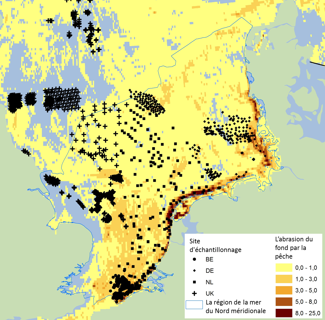
Figure 1: La mer du Nord méridionale comprend les eaux de l’Allemagne, de la Belgique, du Danemark, des Pays-Bas et du Royaume Uni
Les symboles noirs indiquent des échantillons de surveillance du benthos (aucune donnée sur le benthos du Danemark). L’abrasion du fond par la pêche, du point de vue du ratio de la zone balayée, est indiquée en jaune/orange
The southern North Sea assessment to determine benthic habitat community quality was performed using the well-established Margalef diversity index. This is a biodiversity index which gives the species richness of a sample divided by the logarithm of the total abundance within the same sample. The difference between the Margalef diversity index, which is a method to calculate this biodiversity measure; and Margalef diversity, which is the resulting index score of this method should be noted.
A multi-metric index (MMI) is by definition composed of at least two indices. The principal advantage of using a benthic MMI is that it can be more sensitive and precise than a single benthic index to detect changes in pressures and resulting benthic condition. However, this must be tested for each MMI combined with the relevant benthos and pressure data.
It was shown in this assessment that Margalef diversity effectively corrects for differences in sample size and natural variations in total abundance – and associated species richness – within assessment areas such as the German Dogger Bank - Sandy habitat (see Van Loon et al., 2017). Furthermore, it was demonstrated that the Margalef diversity index is the most sensitive and precise index for measuring the effects of fisheries on benthos (Figure 3); and was also proven to be sensitive for nutrients and / or organic enrichment, sedimentation and heavy metals (Figure a, Figure b and Figure c) (Van Loon et al., 2017).
Reference values of the Margalef diversity index are needed to compare the present benthic condition with the reference condition of a specific assessment area. At this stage, reference values for specific areas reflecting main habitat types were used to ensure full comparability of the reference and assessment data (Figure 2). However, in the future it is intended that there will be habitat-specific reference values. A reference value of a benthic index is defined as the average index value within an assessment area in the pristine state. There are probably no areas in the southern North Sea that are in the pristine state, in view of the widespread fisheries pressure. However, it appeared that Margalef diversity reference values used in this assessment can be further tested as a concept by using available benthos data from less impacted areas or a reference value model (high percentile values and depth) (see Van Loon et al., 2017 for more technical details). A similar reference value estimation method has been commonly applied in European Union Water Framework Directive (WFD) MMIs (see Borja and Tunberg, 2011; Van Hoey et al., 2013; Van Loon et al., 2015). In addition, a new model was developed to predict reference values of Margalef diversity for specific assessment areas, using Depth as an input variable. This model appeared to be sufficiently precise and useful in this assessment.
In the European Union WFD, the sensitivity of the proposed benthos MMI for commonly occurring pressures must be demonstrated. This is an essential step, in order to be confident that the selected benthos MMI will correctly and sensitively respond to changes in common (and local) pressures and resulting benthic condition. Similarly, for this OSPAR / European Union Marine Strategy Framework Directive (MSFD) MMI the pressure sensitivity of the Margalef diversity index for fisheries and nutrients and / or organic enrichment (both common pressures) and sedimentation and heavy metals (local pressures) has been demonstrated (Figure a, Figure b, and Figure c). It was found in the pressure-impact testing that the Margalef diversity and species richness benthic indices in general showed a similar sensitivity and precision. However, the Margalef diversity index appeared to be more suitable for predicting reference values using the depth model described above (Figure d1 and Figure d2), which was decisive in selecting the Margalef diversity index as MMI. In addition, it was found in this assessment that multi-metric combinations of the Margalef diversity index with the species sensitivity indices AZTI Marine Biotic Index (AMBI) and the Infaunal Trophic Index (ITI) did not improve the MMI performance compared to the Margalef diversity index alone. Therefore, for reasons of practicality, only Margalef diversity was used.
For MMI optimisation and routine assessments, the availability of a correct, transparent and efficient data analysis tool is important. Therefore, a tailor-made benthos data analysis tool was developed and used for this assessment, the so-called BENMMI (Benthos MMI). This tool is fully operational and is routinely used by several of the southern North Sea countries (see Walvoort and Van Loon, 2016).
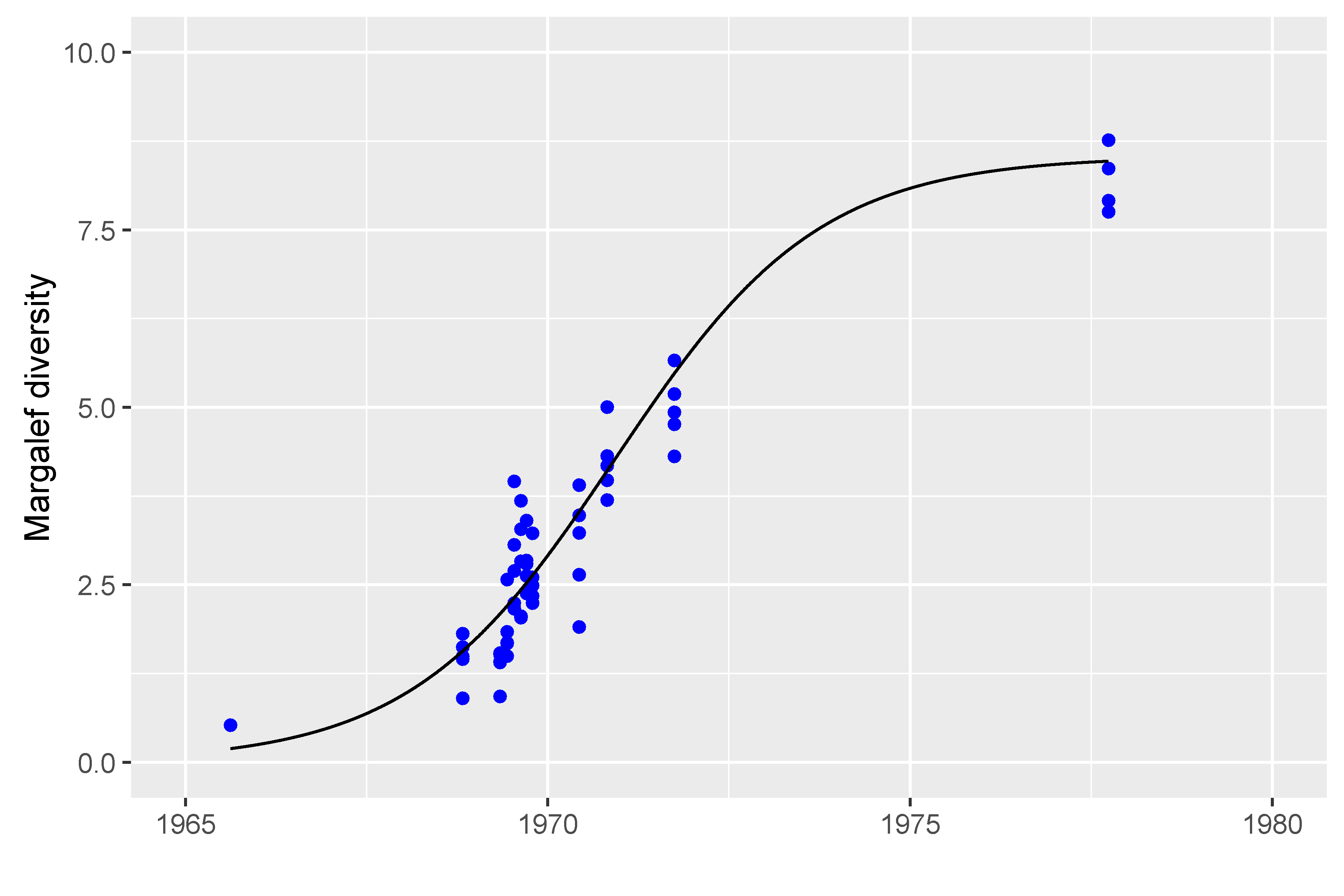
Figure a: Relation between decreasing nutrients and / or organic enrichment (organic enrichment due to pulp mill effluent) and the Margalef diversity index value (R2 = 0.90) in the Swedish Saltkalle fjord which flows into the Northern North Sea
Note that the pulp mill closed in 1966, and that the recovery of the benthos over time due to the decreasing amounts of organic matter on the benthic habitat is visible as an increasing Margalef diversity value.
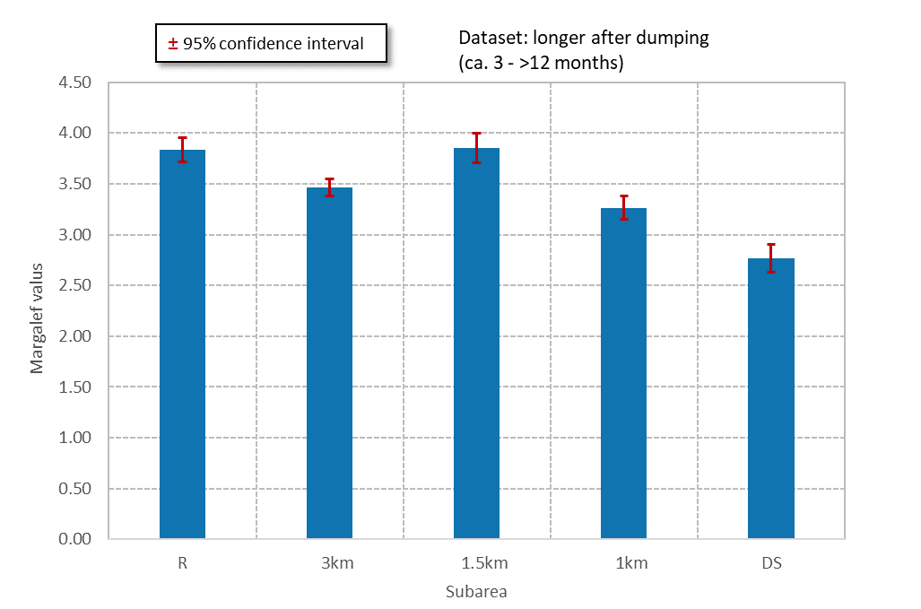
Figure b: Relation between distance of benthos from a German dump site (DS) near Heligoland, and benthic condition as measured by Margalef diversity
Three circular areas around the dump site (1 km, 1.5 km, 3 km) and a reference site at greater distance, unaffected by the dumpsite, were investigated for benthic condition. Significant effects of sediment dumping and sedimentation on the benthos are observed at the dump site and in the 1 km zone.
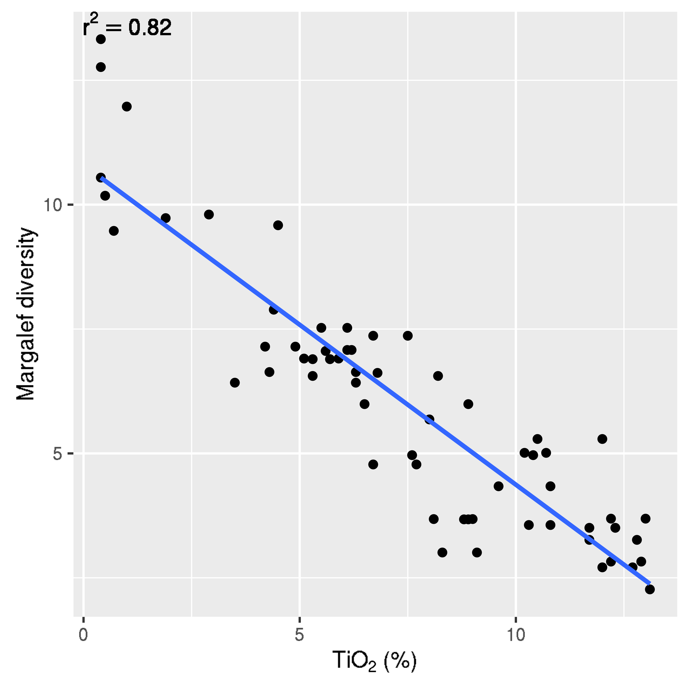
Figure c: Relation between titanium dioxide (TiO2) concentration in sediment and benthic condition in the Norwegian Jossing fjord entering the Northern North Sea, as demonstrated using Margalef diversity
The observed relation is highly significant, as visible in the high R2 value (0.82).
It should be noted that in coastal areas in the theoretical reference (pristine) state, reference values for Margalef diversity are lower than in deeper offshore areas due to higher natural pressures in the coastal zone (wave and occasional storm action, stronger currents).
To have a fully defined assessment process and assessment results, a benthic assessment in generally requires the definition of the following aspects: geographic area and period to be assessed; careful selection of suitable benthos datasets; availability of a pressure-validated, sensitive and precise multi-metric index (MMI); an index reference value estimation and validation method; and a well characterised and documented technical assessment, performed using a correct and efficient assessment tool. The five steps are described in more detail below.
Geographic Area and Period Assessed
The southern North Sea (Figure 1), outside the European Union Water Framework Directive (WFD) one nautical mile zone, was assessed with the Margalef diversity index.
The Belgium part of the area assessed, shown in the bottom of Figure 1, contains one area (North Sea) and two habitats (sand and coarse). These two habitats occur alternately as sand banks and gulleys. The German part of the area assessed, is in the north-east part of the southern North Sea: the coastal zone, the Borkum Reef Ground (south part), the Elbe Urstrom Valley (centre part), the Sylt Outer Reef (north part) and Dogger Bank (north-west part). The Dutch part of the area assessed, is in the centre part of the southern North Sea and contains the coastal zone, the offshore area (south part), the Frysian front (north-east part), the Oyster banks (north part) and the Dogger bank (north-west part). The UK part in the west part of the southern North Sea contain: Farnes East, North East of Farnes Deep, Swallow sand, Holderness offshore (near the UK coast), Markhams triangle (against the border with the Dutch area), north Norfolk Sandbanks (centre of UK part of southern North Sea).
The assessment period was 2010–2015, which was synchronised with the period used for the indicator assessment of Extent of Physical Damage to Predominant and Special Habitats .
Datasets
Benthos data were supplied by Belgium, Germany, the Netherlands and the United Kingdom, and processed by the Netherlands. For Belgium, Germany and the Netherlands it was assessed, based on expert judgement, that full areal coverage was obtained, for the United Kingdom it was assessed to be partial areal coverage, and no data from Denmark were available. A criterion for sufficient areal coverage had not been discussed and agreed at the time of writing but will be part of the further development of this indicator assessment. For the United Kingdom, some benthos data from assessment areas lying just north of the southern North Sea were assessed (Farnes East, North-East of Farnes Deep, Swallow Sand), in view of the limited data available. The assessment areas were combined with European Nature Information System (EUNIS) Level 3 habitat information (Sand, Mud, Coarse, Mixed), based on an average of 30 samples per area, per year. In addition, median depth data were collected for additional characterisation of the assessment area and reference value modelling. A more detailed characterisation of these data was given by Van Loon et al. (2017, Table 1).
Fisheries activity maps from the International Council for the Exploration of the Sea (ICES; surface and sub-surface activity per grid cell of 0.05° × 0.05°) version January 2016 were used (Figure 1 for an example)(ICES, 2016). The ICES grid cell activity values were averaged per assessment area, for surface and sub-surface activity separately, in order to average out the spatial variation sufficiently, which improved the pressure-impact relationship considerably. It should be noted that the disturbance values being used for the assessment of physical damage on special and predominant habitats were not used for this assessment, but that the same abrasion pressure layer, derived from the ICES fisheries data, was used.
Index Calculation
The optimal benthic index for the southern North Sea, Margalef diversity, was calculated for all southern North Sea benthos samples using the BENMMI tool (benthos multi-metric data analysis software). For each assessment area, the annual average normalised value of Margalef diversity was calculated. The normalised index value is the Margalef diversity value of a sample divided by the reference value of Margalef diversity for the specific assessment area where the sample was taken. It should be noted that Margalef reference values are obtained using reference data from the North Sea (where available) or modelled reference values using least disturbed benthos data monitored by the same national laboratory. This favours good comparability of the reference and assessment Margalef diversity values.
Reference Value Estimation and Validation
An important step in getting realistic normalised Margalef diversity values is to estimate realistic Margalef diversity reference values for each assessment area, such as for the UK_SwallowSand-Sandy habitat. This was done by calculating the 99 (or in some case 95 and 75) percentile index value of a sufficiently large set of Margalef diversity values (with a minimum of 20) for the specific assessment area, as has been used for the European Union WFD by several countries (Van Loon et al., 2015). The use of the 99 or 95 percentile value as the average reference value accounts for a certain amount of index degradation. However, this percentile method was refined by allowing the use of lower percentile values, in case of lower assessment area degradation, as published by Hering et al. (2006). For example, in a pristine assessment area the 50 percentile Margalef diversity value would be the correct reference value. This estimation of lower assessment area degradation could be made using the fisheries activity data from ICES (2016) (see Datasets).
The following quality codes were assigned to the benthos datasets per assessment area: quality code 1 (one monitoring year and at least 20 samples); quality code 2: (two monitoring years and 30 or more samples); quality code 3: (three or more monitoring years and 50 or more samples) (Van Loon et al., 2017. Note that only estimated reference values with quality codes 2 and 3 were used for the Depth-Reference_Value model.
The reference period used per assessment area was in principle six consecutive years, in which the highest period average of the annual average value of Margalef diversity was found. This means that the least disturbed benthos dataset per assessment area is used, as recommended in the OSPAR manual on Biodiversity (OSPAR, 2012). The use of a six-year period appears to give stable reference values, in which temporal variation has been averaged out.
The obtained reference value estimates were validated using the depth model for Margalef diversity (Figure d1; Van Loon et al., 2017), and in some case corrected for better fit on this curve using an adjusted percentile value based on the available fisheries activity data. All Margalef diversity reference values showed a deviation of less than 10% from the depth model, which was considered useful precision.
Assessment of the Southern North Sea
The period average (2010–2015) of the normalised index values of Margalef diversity for each assessment area with at least 20 samples and one monitoring year are shown in Figure 2. The precision of the annual average normalised Margalef diversity (Dn) value per assessment area was calculated as the 90% confidence interval.
Résultats
L’indice de diversité de Margalef montre que dans l’ensemble l’on observe, dans les zones côtières peu profondes de l’Allemagne, de la Belgique et des Pays-Bas, des conditions benthiques relativement inférieures à celles des zones plus profondes du large (Figure 2). Les résultats de l’évaluation révèlent que, en dépit de valeurs de référence côtières plus faibles, les valeurs de diversité de Margalef normalisées (définies comme des valeurs d’indice des échantillons divisées par la valeur de référence) dans les zones côtières de l’Allemagne, de la Belgique et des Pays-Bas sont généralement inférieures à celles des zones du large (telles que le Dogger Bank allemand et néerlandais). Les zones de la mer du Nord méridionale évaluées (Voir la figure 2) sont basées sur le système de classification des habitats EUNIS 3. Chaque type d’habitat a été évalué séparément.
C’est la première fois que l’on peut établir des liens significatifs entre la valeur de diversité de Margalef normalisée (fourchette 0–1) à une échelle internationale plus vaste et la pression moyenne exercée par la pêche dans les zones d’évaluation de la mer du Nord méridionale (Figure 3). La courbe de la figure 3, révèle une diminution exponentielle de la condition des communautés d’habitats benthiques dans la fourchette des balayages de subsurface / an des activités de pêche de 0 à 2,3, suivie par une stabilisation de la condition des communautés pour des activités de pêche plus importantes. Cette courbe révèle qu’une activité de pêche >2,3 balayages de sub-surface / an entraîne une communauté benthique résiliente de plus basse qualité, demeurant au mêm e niveau de qualité dans le cadre d'activités de pêche croissantes. Il convient de noter que l’on a fait la moyenne des activités de pêche par zone-année d’évaluation afin d’obtenir une meilleure courbe. L’intervalle de confiance à 90% pour chaque point de données (évaluation par zone par an) est indiqué. La relation est extrêmement significative (p < 0,0001).
Généralement, cette activité de pêche est relativement élevée dans les zones côtières (Figure 1) et relativement faible dans les zones du Dogger. Le Dogger Bank s’étend de la partie orientale des eaux britanniques aux eaux septentrionales néerlandaises et allemandes. En résumé, l’indice de diversité de Margalef normalisé révèle des différences nettes de la qualité des communautés benthiques entre les zones d’évaluation de la mer du Nord méridionale (Figure 2).
Les résultats de cette évaluation décrivent l’impact de la pêche sur les habitats benthiques. D’autres pressions anthropiques exercées dans la zone côtière, telles que l’enrichissement en nutriments et / ou organique , les immersions et la sédimentation, le rechargement en sable côtier (sur le littoral), l’extraction de sable et les contaminants peuvent cependant s’ajouter également à la série de pressions côtières exercées sur les habitats, selon les conditions locales. L’enrichissement en nutriments et / ou organique est la seule de ces pressions côtières typiques pouvant se manifester à une échelle plus vaste alors que les autres pressions sont généralement exercées à une échelle plus locale.
La méthode utilisée pour cette évaluation inspire une confiance modérée et la disponibilité des données inspire une confiance élevée / modérée.
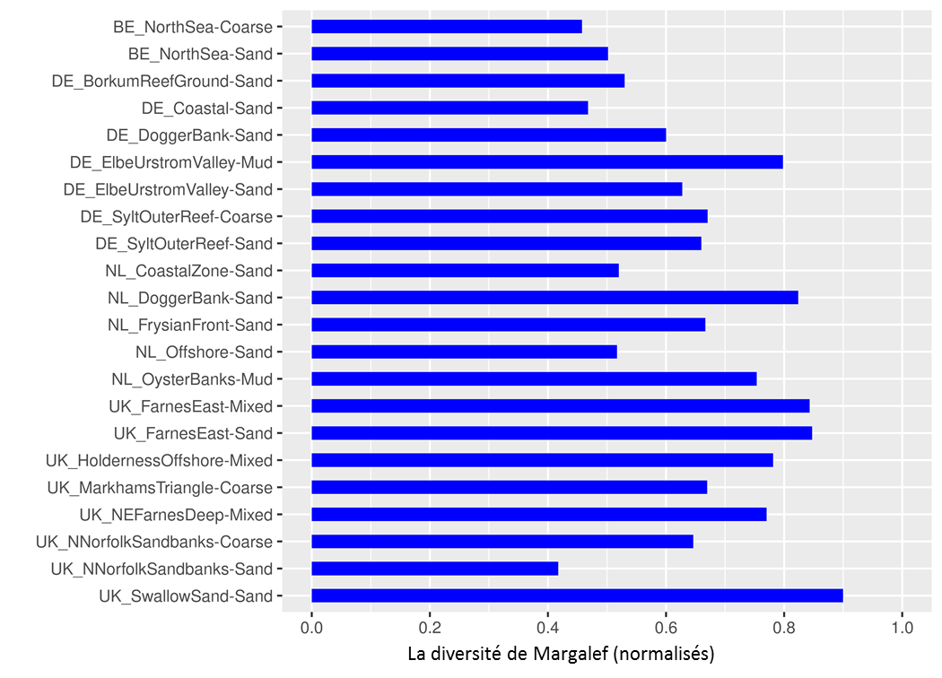
Figure 2: Résultats de l’évaluation des zones d’évaluation de la mer du Nord méridionale (types d’habitat) utilisant les résultats de la diversité de Margalef normalisés (fourchette 0–1) en faisant la moyenne pour la période de 2010 à 2015
Il convient de noter que les résultats plus élevés de l’indice indiquent une meilleure qualité des communautés benthiques.
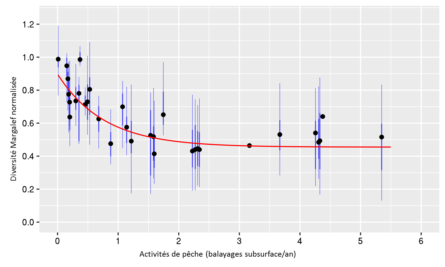
Figure 3: Rapport entre les activités de pêche (subsurface) et la valeur de diversité de Margalef normalisée
Démontré pour toutes les données sur le benthos de la mer du Nord méridionale durant la période de 2009 à 2013 de zones d’évaluation pour lesquelles on dispose de valeurs de référence suffisamment fiables.
The Margalef diversity index gives the species richness of a sample divided by the logarithm of the total benthic abundance within the same sample. Consequently, this index is more robust for the differences in sample size, which occur in this international assessment (such as grab samplers and box cores used). In addition, it was demonstrated that there is a clear linear relation between the natural logarithm of the total abundance and species richness for single samples within a single survey of a specific area-habitat (Van Loon et al., 2017). This means that Margalef diversity actually corrects for natural variations in species richness in a monitoring survey in a specific assessment area, apparently caused by differences in total abundance within the same assessment area, and in that way produces more precise index values than species richness. As a result, Margalef diversity produces more comparable reference values, which can be related well with median depth (Figure d1). In contrast, the reference values of species richness in the southern North Sea show much more variation due to the differences in sample size and natural variation within a specific assessment area, and can be modelled poorly (Figure d2). This was the deciding factor in selecting the Margalef diversity index for this assessment.
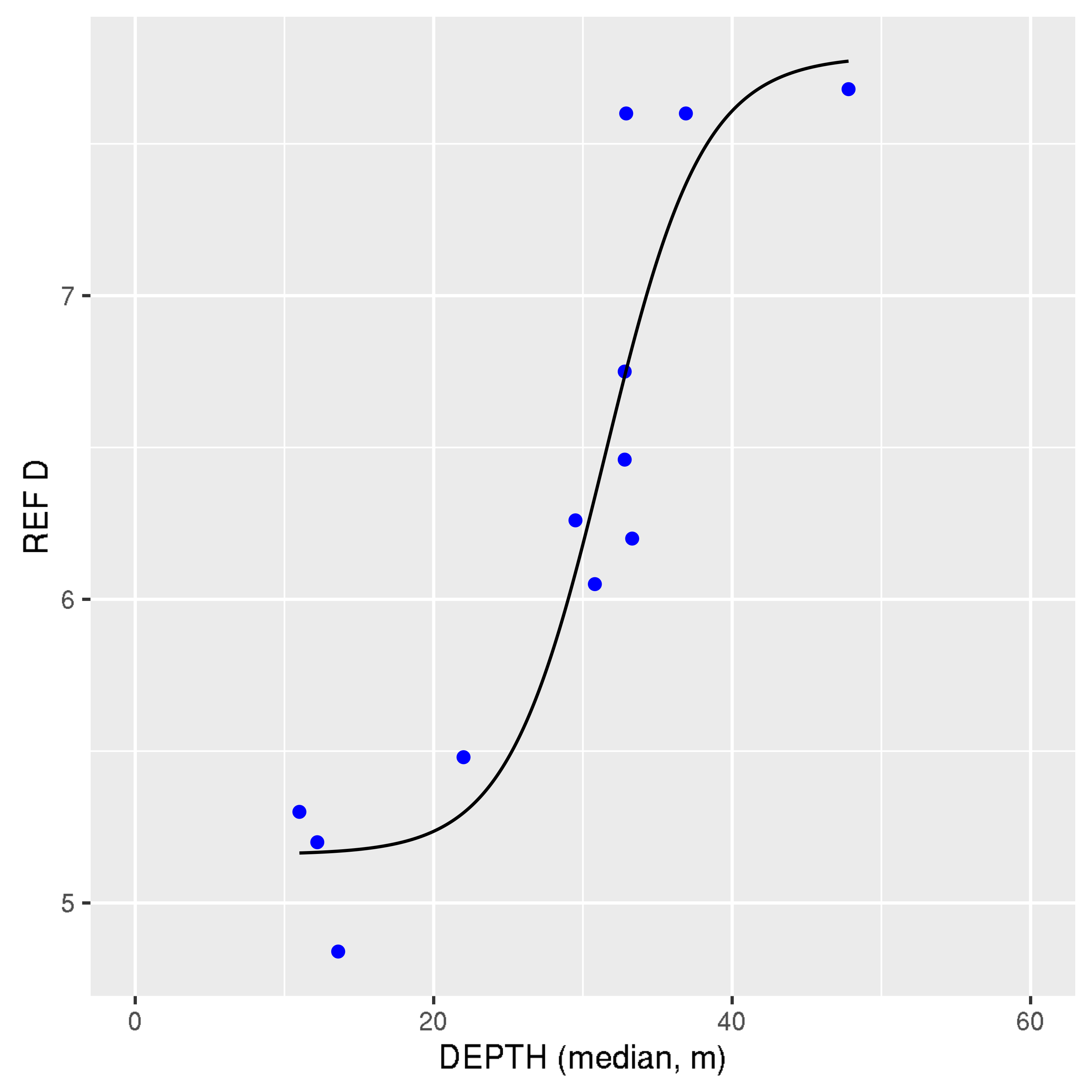
Figure d1: Relation between median depth and the estimated reference value (REF) of Margalef diversity (D) using national benthos datasets (with sufficient amounts of data) within the southern North Sea sub-region.
The precision of this model is good (R2 = 0.86). Note that this model is more precise than for species richness (see Figure d2).
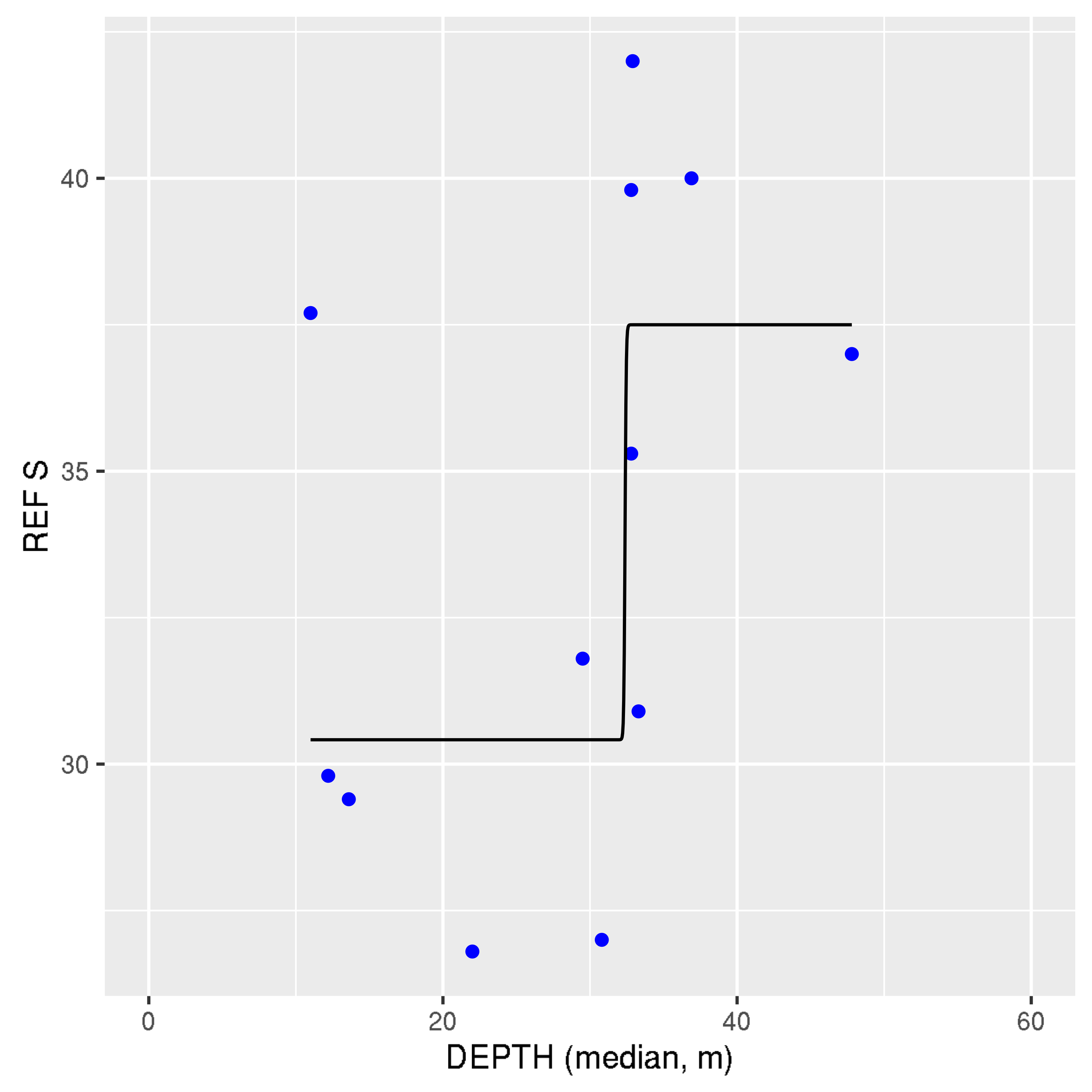
Figure d2: Relation between median depth and the estimated reference value (REF) of species richness (S) using national benthos datasets (with sufficient amounts of data) within the southern North Sea sub-region.
The precision of this model (R2 = 0.48) is much lower than for Margalef diversity (see Figure d1).
It appears from this model that depth is the dominating habitat factor for Margalef diversity. Depth is related to many environmental variables such as natural physical pressures (currents, waves, storms) and consequently sediment composition, natural light limitation, and human fisheries pressures. This model could be confirmed using information from the peer-reviewed literature. This model was very useful to check the reference values of Margalef diversity obtained via another method. In addition, it should also be noted that this model is primarily applicable to predominant habitats that do not have hard substrate structures, such as biogenic reefs. The Margalef reference value model has not been calibrated to apply to habitats containing hard substrate structures, and may therefore underestimate the reference values in these more diverse habitats.
The benthos multi-metric data analysis software (BENMMI), that was specially developed for the purpose of OSPAR / European Union Marine Strategy Framework Directive benthos multi-metric index (MMI) optimisation and routine analyses, appeared to work efficiently and effectively as tested by most countries in the southern North Sea sub-region. This software has resulted in the use of a standardised benthos data format within this region, and produces extensive and standardised data analysis reports, which are very useful as documentation for reporting and quality control. Several new functions, including monitoring precision and power analyses, were included in this tool based on emerging needs during the OSPAR condition of benthic habitat indicator development process. This tool (developed in the statistical programming language R) will be maintained and adapted for future needs, and will be available in 2017 at https://cran.r-project.org/web/packages/BENMMI/index.html. In principle, this tool is also suitable for application in the other OSPAR sub-regions. Suitability must be checked by testing benthos and pressure data from the specific sub-region, and some modifications of the BENMMI tool may be needed.
On average, the 90% confidence intervals of the assessment results were: Belgium ±0.047; Germany ±0.111; Netherlands ±0.055; United Kingdom ±0.053. First analysis shows that a proposed minimum precision of ±0.06, can be met in most cases. This value is still under discussion.
The proposed precision should be reached for each assessment area. It should also be noted that this precision criterion does not reflect the benthic condition of the specific assessment area, but only the precision with which this benthic condition can be assessed.
Assessment of Confidence
This method builds further on common European Union Water Framework Directive (WFD) methodology and has been tested extensively with a large amount of southern North Sea benthos and pressure data. However this is the first time it has been assessed on the regional scale, the results of which have been submitted for scientific publication, therefore the confidence in the method is moderate.
The benthos data availability is generally spatially and temporally sufficient for the assessment, but for some areas was spatially limited and so has been rated high / moderate.
Conclusion
Cette évaluation s’est focalisée sur l’évaluation de la condition des communautés d’habitats benthiques - Habitats subtidaux de la mer du Nord méridionale à titre de composant d’un indicateur plus exhaustif de la condition des habitats benthiques définissant les communautés ( Condition des communautés d’habitats benthiques ).
L’indice de diversité de Margalef sélectionné a évalué la qualité des communautés benthiques et révèle des différences nettes entre les zones d’évaluation. La qualité benthique des zones côtières est habituellement plus basse (diversité de Margalef réduite par rapport aux valeurs de référence), ce qui est en partie dû aux activités de pêche relativement élevées. Les zones du large, en particulier celles plus profondes, ont une diversité de Margalef relativement plus élevée ou élevée par échantillon par rapport aux valeurs de référence.
Cet indice de diversité semble être l’indice benthique le plus sensible pour indiquer les différences des impacts des pressions exercées par la pêche sur la condition des communautés benthiques dans les zones évaluées. Cet indice est également l’indice benthique le plus sensible pour indiquer l’enrichissement anthropique en nutriments et / ou organique, la sédimentation et les pressions exercées par les métaux lourds dans les zones évaluées.
C’est la première fois qu’un indice de la diversité a été appliqué à une échelle géographique si vaste (s’étendant sur quatre pays). Cette méthode et le logiciel sur mesure correspondant ont révélé de bons résultats. Cette méthode pourrait également s’appliquer à d’autres sous-régions OSPAR dans la prochaine évaluation.
The methods to estimate reference values of Margalef diversity for specific assessment areas (using the variable percentile method), and to validate them (using the new depth model), appear to work well in the southern North Sea. Margalef diversity reference values showed a much better relation with Depth than species richness reference values, which was the decisive factor for selecting Margalef diversity as an index for the southern North Sea.
A sufficient amount of benthos data could be collected to perform an assessment for the period 2010–2015. However, Danish benthos data were lacking at the time of the assessment, and for United Kingdom greater areal coverage in the southern North Sea with benthos data is probably needed.
The fisheries activity data from the International Council for the Exploration of the Sea (ICES) appeared to be useful for the pressure-impact sensitivity testing of the candidate benthic indexes and for assisting in the reference value estimation for Margalef diversity.
It is recommended to use a minimum benthos sampling frequency of twice per six-year European Union Marine Strategy Framework Directive period, in order to be able to average out temporal benthos variation sufficiently.
Tailor-made benthos multi-metric index data analysis software has been developed and appears to be efficient, effective and transparent for performing the Margalef diversity calculations for the southern North Sea assessment. The software can be extended with other benthic indexes and used in other OSPAR sub-regions as required.
There are several apparently high-quality benthos designated Marine Protected Areas in UK waters (Farnes East, north-east of Farnes Deep, Swallow Sand), which could be useful for further investigation of high quality North Sea benthic habitats. The German and Dutch Dogger Bank also shows a relatively high benthic condition.
Lacunes des connaissances
Les valeurs de référence de la diversité de Margalef pour les zones d’évaluation semblent bien correspondre à la profondeur variable de l’environnement. La profondeur est une force motrice importante d’une série de variables des habitats, y compris la composition des sédiments. On peut cependant améliorer encore les valeurs de référence en incorporant explicitement dans le modèle le type de sédiment.
Il faudra développer une valeur d’évaluation pour les résultats de l’indice de diversité de Margalef. Il pourrait également s’avérer utile d’établir une distinction entre la valeur de cette évaluation pour des zones d’évaluation spécifiques. Il y aura également lieu d’étudier plus avant la disponibilité des données sur le benthos dans l’ensemble de la zone maritime OSPAR pour une application plus étendue de l’indicateur à l’avenir.
A criterion for sufficient areal coverage of benthos sampling will be discussed within the OSPAR benthic habitat expert group in the near future. A coordinated monitoring programme across OSPAR countries for collecting a sufficient amount of benthos data is also needed.
The relationship between Condition of Benthic Habitat Communities and Extent of Physical Damage to Predominant and Special Habitats results should be investigated further.
Although it was not considered a problem in this assessment, it is recommended to check the harmonization of the taxonomic level of detail of different laboratories in the southern North Sea.
Assessment precision results for the southern North Sea are available and could be used to define a minimum required precision for the Margalef diversity method.
Borja, A., Tunberg, B.G., 2011. Assessing benthic health in stressed subtropical estuaries, eastern Florida, USA using AMBI and M-AMBI. Ecol. Indic. 11, 295–303.
D. Hering, C.K. Feld, O. Moog and T. Ofenbock, 2006. Cook book for the development of a Multimetric Index for biological condition of aquatic ecosystems: experiences from the European AQEM and STAR. Hydrobiologia (2006) 566:311–324.
D.W.W. Walvoort and W.M.G.M. van Loon, 2016. BENMMI user manual. http://publicaties.minienm.nl/documenten/user-manual-benmmi-3-0.
ICES 2016. Updated ICES fisheries GIS maps version jan 2016. Available from: http://ecosystemdata.ices.dk/download/ OSPAR_mapping_bottom_fishing_intensity_data_outputs_2015.zip
OSPAR, 2012. MSFD Advice Manual and Background Document on Biodiversity. Version 3.2.
Van Hoey, G., Permuy, D. C., Vandendriessche, S., Vincx, M., & Hostens, K. (2013). An ecological quality status assessment procedure for soft-sediment benthic habitats: weighing alternative approaches. Ecological Indicators, 25, 266-278.
W.M.G.M. van Loon, A.R. Boon, A. Gittenberger, D.J.J. Walvoort, M. Lavaleye, G.C.A. Duineveld, A.J. Verschoor, Application of the Benthic Ecosystem Quality Index 2 to benthos in Dutch transitional and coastal waters, Journal of Sea Research, Volume 103, September 2015, Pages 1-13, ISSN 1385-1101, http://dx.doi.org/10.1016/j.seares.2015.05.002.
W. van Loon, D. Walvoort, M. Lavaleye, G. Duineveld, G. van Hoey, A. Blandon, C. Herbon, G. Philips, R. Pesch, P. Schmitt, J. Scholle, K. Heyer, M. Blomqvist, 2017. Multi-Metric Index assessment of benthos in the southern North Sea using Margalef D, submitted for publication.
Willem van Loon, Dennis Walvoort, Gert van Hoey, Christina Vina-Herbon, Abigayil Blandon, Roland Pesch, Petra Schmidt, Jorg Scholle, Karin Heyer, Marc Lavaleye, Graham Philips, Gerard Duineveld, Mats Blomqvist, 2017. A regional benthos assessment method for the southern North Sea using Margalef diversity and reference value modelling.