

What is OSPAR?
The OSPAR Convention
OSPAR originated in 1972 with the Oslo Convention against dumping and was broadened to cover land-based sources and the offshore industry by the Paris Convention of 1974. The two conventions were unified, updated and extended to form the 1992 OSPAR Convention. A new annex on the protection and conservation of the ecosystems and biological diversity of the Maritime Area was adopted in 1998 to cover adverse effects of human activities other than pollution.
The OSPAR Convention is signed and ratified by 15 Governments and the European Union. The 15 Governments are Belgium, Denmark, Finland, France, Germany, Iceland, Ireland, the Netherlands, Norway, Portugal, Spain, Sweden and the United Kingdom of Great Britain and Northern Ireland, along with Luxembourg and Switzerland.
The Convention for the Protection of the Marine Environment of the North-East Atlantic (the ‘OSPAR Convention') entered into force on 25 March 1998.
The OSPAR Commission
The OSPAR Commission provides a forum through which the 16 Contracting Parties coordinate international cooperation on the protection of the North-East Atlantic marine environment. The OSPAR Commission shares common regulation and management of the human activities impacting our seas, supported by monitoring and assessment of the state of the seas. The OSPAR Commission can adopt legally binding decisions, supplemented by recommendations and other agreements. As one of four Regional Seas Conventions covering European waters, OSPAR ensures, as much as is practicable, a common approach among the European Regional Seas Conventions to the management of the human activities that have the potential to impact our seas, and to the assessment of the marine environment. Furthermore, OSPAR facilitates the coordinated implementation of the MSFD, with the objective of attaining good environmental status for European waters.
What is the OSPAR Intermediate Assessment 2017?
The IA 2017 further develops OSPAR’s understanding of the marine environment of the North-East Atlantic and its current status. It demonstrates OSPAR’s progress towards realising its vision of a clean, healthy and biologically diverse North-East Atlantic, used sustainably.
OSPAR’s previous holistic assessment, the QSR 2010, was a culmination of ten years of joint assessment and monitoring by OSPAR Contracting Parties. Seven years on, and with the benefit of significant developments in monitoring and assessment methodology, the IA 2017 provides an update on the 2010 assessment as well as presenting some new indicators and assessment methodology. The actual time period for the range of assessments presented in the IA 2017 varies since the reporting period is parameter-specific. The objective has been to use the most recent data available. For hazardous substances the assessment period in the IA 2017 incorporates data up to 2015, inclusive. Eutrophication indicators, together with nutrient inputs, incorporate data up to 2014, inclusive. However, the reader is encouraged to note the period covered by the individual assessments.
Although this is an OSPAR Report, OSPAR Contracting Parties that are also EU Member States have the opportunity to use the information presented in the IA 2017 for their update in 2018 to the EU on the initial assessment (2012) for the MSFD. However, it should be noted that at this point in time, OSPAR IA 2017 indicator assessment values are not to be considered as equivalent to proposed EU MSFD criteria threshold values.
What is the Geographic Scope of OSPAR’s IA 2017?
All assessments within this IA 2017 are undertaken within a section of the OSPAR Maritime Area, often with reference to one or more of the five OSPAR Regions (Figure 1). Stretching from the North Pole to 36°N, the OSPAR Maritime Area covers a diverse range of environmental conditions and different ecosystems. For each individual assessment (see ‘’ and ‘’), an appropriate scale of assessment has been selected by the relevant experts.
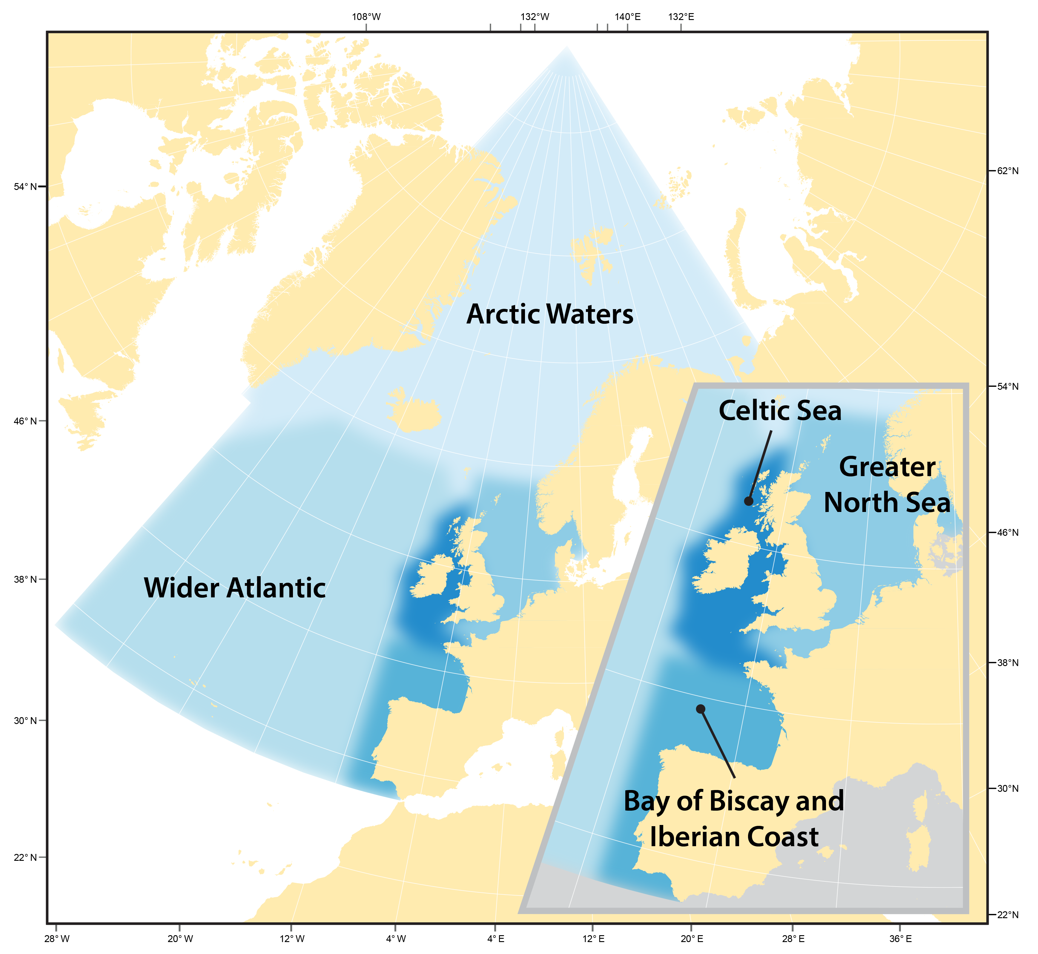
Figure 1: The OSPAR Maritime Area is divided into five Regions (Table 1) for assessment purposes: Arctic Waters, Greater North Sea, Celtic Seas, Bay of Biscay and Iberian Coast and Wider Atlantic
While the outer boundaries of the OSPAR maritime area are defined by the OSPAR Convention, the boundaries of the Regions are not. Their delineation is dependent on the assessment context. The Swedish / Danish Sound, Roskilde fjord and Isefjord have been included for the purposes of the IA 2017 only. Also, for the purposes of the IA 2017 only, the OSPAR boundary between the Greater North Sea and the Celtic Seas in the English Channel has been realigned to reflect the EU MSFD Sub-Region.
The text of the Intermediate Assessment 2017 refers to the geographic names of the OSPAR Regions, whereas the Quality Status Report (QSR) 2010 primarily referred to the OSPAR Regions I - V. The basis of the change is that factors such as seasonality, natural fluctuations in temperature and salinity, and biological consequences of natural variation, mean that there is not going to be a sharp transition at the point where one OSPAR Region becomes an adjacent Region (see Figure 1).
The actual division between the five regions cannot be taken as absolute. This is because the marine environment is dynamic and although there are some clear divisions that can be defined (depth for example), factors such as seasonality, natural fluctuations in temperature and salinity, and biological consequences of natural variation, mean that there is not going to be a sharp transition at the point where one OSPAR Region becomes an adjacent region. For the IA 2017, regions are described by their names (i.e. Arctic Waters, Greater North Sea, Celtic Seas, Bay of Biscay and Iberian Coast, and Wider Atlantic), rather than the more traditional numerical system of OSPAR Regions I–V used in, for example, the QSR 2010. EU MSFD sub-regions have similar nomenclature, and for the purposes of this report can be taken as equivalent assessment status to the OSPAR Regions – unless otherwise indicated (Table 1 , Figure 1).
| Terminology used in the IA 2017 to describe the OSPAR Regions | Terminology used in the QSR 2010 to describe the OSPAR Regions | Sub-regions described in the EU MSFD that overlap with the OSPAR Regionsᵃ |
|---|---|---|
| Arctic Waters | I | Celtic Seasᵇ |
| Greater North Sea | II | Greater North Sea |
| Celtic Seas | III | Celtic Seas |
| Bay of Biscay and Iberian Coast | IV | Bay of Biscay and Iberian Coast |
| Wider Atlantic | V | Celtic Seas, Bay of Biscay & Iberian Coast, Macaronesia |
Table 1 Notes
aThe extent of overlap varies and in some cases is very small;
ba small, northerly, part of the EU Celtic Seas sub-region overlaps with the OSPAR Arctic Waters Region hence the terminology used here.
Some assessments in this IA 2017 also consider part of The Sound (Öresund), which is outside the OSPAR Maritime Area, but is connected to the Kattegat. The rationale for this is to align the OSPAR Region to the MSFD sub-region. This is beneficial for Sweden and Denmark when using the IA 2017 for updates of the initial assessment for the MSFD due in 2018, it is also sensible from a biological perspective because the biota and biological dynamics of The Sound are to some extent similar to conditions in the Kattegat.
Specific assessments have used further geographical divisions. These are often described within an OSPAR Region. An example is the ecohydrodynamic zones (EHDs) in the Greater North Sea and Celtic Seas that are used in the phytoplankton assessments. EHDs are constructed based on key water column features, which are important to plankton community structure and dynamics. It is therefore relevant to use these in such an assessment.
What is included in the IA 2017?
The IA 2017 provides background information and assessments of human pressures on the marine environment and biological diversity of the OSPAR Maritime Area. Ultimately, there are some key messages articulated. These provide concise assessments, often in respect of species or delivery of The OSPAR Strategy.
There is a need for those who manage human activities that impact on our seas to understand the effects of such activities on the biology, physics and chemistry of these waters. Furthermore, the effectiveness of any action must be assessed. In preparing the IA 2017, assessments have been made against agreed assessment criteria when available. Alternative trend assessments, have been used when specific assessment thresholds have not been available. However, when evaluating the assessments, it is necessary to take account of the change and variation which dominates marine systems. While much of this change and variation is entirely natural, some biological, physical and chemical disturbances are the result of human pressures. It is only through carefully conducted research and monitoring that the natural and anthropogenically-forced changes can be separated to provide a clear picture of the impact that humans are having on the seas and oceans. Basic information on the characteristics of our seas is crucial. To this end, an overview of the physical and chemical characteristics of the OSPAR Maritime Area is presented in Climate and Ocean Acidification.
Throughout this IA 2017, the complexity of the systems is illustrated and discussed in the context of the various indicators that are being used to assess human pressures and the associated effects. In any report or assessment, the ‘whole’ is sub-divided into ‘elements’. However, the reality is that there are significant interrelationships between the various elements of marine systems and this should always be remembered when assimilating the information presented for the range of indicators presented in the IA 2017.
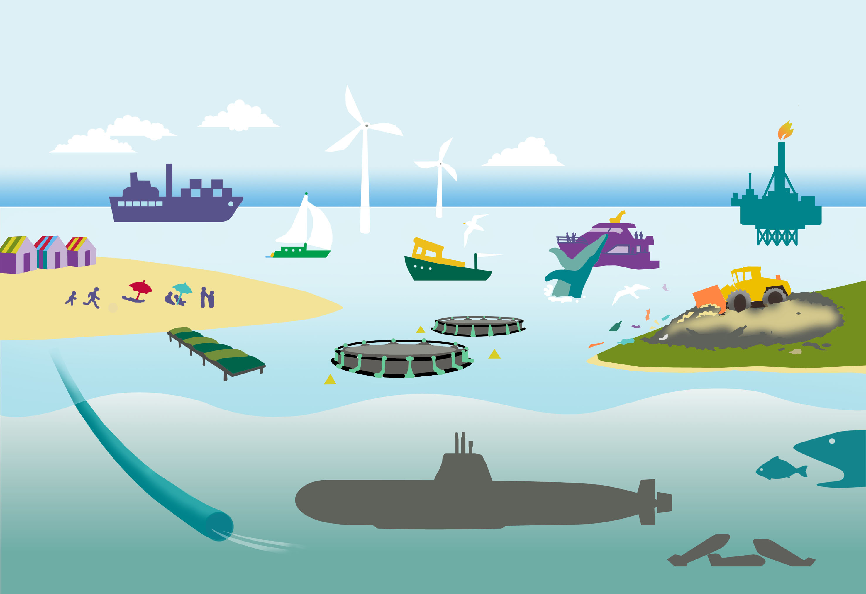
Figure 2: Uses and activities in the marine environment are many and varied
Our seas provide us with the oxygen we breathe, food and energy (both hydrocarbon-based and renewable energy) as well as being a source of pleasure through tourism and marine sporting activity. In addition, they influence the global climate in addition to providing a global network of ports and shipping routes used for the transportation of goods around the world.
In addition to exploiting the resources our marine waters have to offer, people are also drawn to the ocean for recreation and attach a strong cultural importance and identity to it. However, with so many pressures and users, combined with rising sea temperatures and compelling evidence of ocean acidification, it is clear that human activity is greatly impacting on our seas (Figure 2). This may have economic impacts for some activities. Pressures on our seas are presented in detail through a series of indicators.
Although at an early stage, the IA 2017 demonstrates an improved understanding of the economic and social value of the OSPAR Maritime Area . Information presented is a preliminary consideration of the methodology associated with assessing economic and social value. The need for this information introduces new concepts, parameters and discussion points which add to the complexity of the assessments, but will improve the overall management of human activities impacting marine ecosystems. As decision-makers will be assisted in taking account of the socio-economic implications of any proposal.
Ultimately there is a need to understand how marine ecosystems function; the natural variability in the system; the anthropogenically-forced changes (these being the only changes we can potentially manage); the effects of multiple, cumulative human impacts; and the economic and social implications / benefits of our exploitation of the seas.
The various assessments that are presented in the IA 2017, cover the physics, chemistry and biology of the North-East Atlantic, contribute to our understanding, advance knowledge, and provide policymakers with new evidence on which to base their decisions. However, the development of some indictors, especially the biodiversity indicators, is at an early stage.
Intrinsically, some aspects of the IA 2017 are exploratory with the objective of providing an assessment of the applicability of some of the indicators and, ultimately, their use in future OSPAR Assessments. This will ensure that OSPAR continues to focus on delivering assessments using robust indicators which will provide the basis for assessing progress towards realising its vision of a clean, healthy and biologically diverse North-East Atlantic, used sustainably.
The OSPAR IA 2017 is presented as part of a structured online information system. It reports current understanding of the environmental features of the North-East Atlantic, which includes assessments on the impacts of climate change and other physical pressures, providing key information on temperature, salinity and other physical features. Information on these features can be accessed here. An outline of the socio-economic aspects of the OSPAR Maritime Area and how this will be developed, can be accessed here .This component highlights the importance of combining natural science with socio-economics as well as providing assessments that take account of the impact of regulation and environmental change on communities.
Assessments of pressures from various human activities and their impact on the status of biodiversity are each given their own sections, highlighting the importance of both topics. A stand-alone assessment sheet has been prepared for each indicator. This approach allows Contracting Parties of the OSPAR Convention to use the indicator assessments pertinent to their waters in isolation or combination, as appropriate for their individual national reporting requirements.
The latest OSPAR developments in ecosystem assessment methodologies are detailed in the Ecosystem Assessment Outlook. This section illustrates a methodology that can be developed for use in future assessments of the North-East Atlantic as well as providing some examples of the approach applied to the Indicator Assessments and Thematic Assessments of the IA 2017.
The manner in which the IA 2017 is presented, permits readers to rapidly track the evidence on which the findings and conclusions are based. Accessibility brings visibility and allows everyone to consider the data on which the assessments have been made. This is intended to stimulate a discussion which will ensure that the right balance is struck with respect to managing the human activities with the potential to impact on the North-East Atlantic.