

Management and policy responses to protect, improve and recover benthic ecosystem
The actions taken by OSPAR in relation to the management of specific human activities or pressures, including eutrophication, renewable energy development, near-shore and deep-sea mineral extraction, dredging, oil and gas extraction and cable placement, all contribute to addressing the impacts from pressures and should contribute to improving the status of benthic habitats. The Collective Arrangement provides a useful framework for working with other competent organisations on responses relevant to benthic habitats that are outside OSPAR’s competence in selected areas outside national jurisdiction, for example in relation to fisheries.
OSPAR has identified eighteen habitats considered to be of concern in the North-East Atlantic in coastal, shelf and deep waters. Recommendations for actions to be taken by Contracting Parties nationally and collectively to protect and conserve these species have been adopted. At present, it is very challenging to evaluate whether these measures will be able to reduce the pressures and human activities that continue to undermine benthic habitats in the North-East Atlantic. In part this is because one response may address multiple activities and/or pressures. In addition, some response measures are not necessarily producing data that can be included in the current Indicator Assessments aimed at evaluating the effectiveness of those measures on the recovery of benthic ecosystems. Overall, the measures currently being implemented do not seem to have improved the status of benthic habitats.
The OSPAR network of Marine Protected Areas (MPAs) is an important response for improving the status of benthic habitats, including but not limited to those habitats identified in the OSPAR List of threatened and/or declining species and habitats. The development of the network is progressing in line with regional and global commitments. OSPAR listed habitats in the Arctic region are notably underrepresented in the OSPAR MPA network. Some habitats such as Cymodocea meadows are naturally region-specific, and others like carbonate mounds are not sufficiently known or included, which increases the challenge of understanding the ecological coherence of the MPA network.
Benthic Habitat R-section ANNEX:
The section development has been supported by the collation of relevant measures: measures of relevance to benthic habitats included in this section
Section Overview
This section describes the responses taken to minimise the effect of human activities and their resulting pressures or impacts on ecosystem services, and the responses that aim to improve the state of benthic habitats in the North-East Atlantic. These can include the development of policy or legislation and measures to manage or regulate specific human activities or to mitigate impacts on ecosystem services.
The section considers the diversity of benthic habitats that occur across all regions of the OSPAR Maritime Area, including those in coastal and shelf seas as well as deep seas within and outside of national jurisdiction. The primary focus is on responses that have been adopted by the OSPAR Commission to implement Contracting Parties’ commitments under the OSPAR Convention and the strategic objectives of the North-East Atlantic Environment Strategy (NEAES 2030). Article 22 of the OSPAR Convention requires that Contracting Parties report to the OSPAR Commission at regular intervals on the steps they have taken to implement OSPAR Decisions and Recommendations, the effectiveness of those measures and the problems encountered during their implementation. The section also aims to describe the progress made in implementing these measures and whether they are working in terms of achieving the ambitions set out in NEAES 2030. It attempts to set OSPAR’s responses in the wider policy context, and the responses of other competent organisations are also considered where they are pertinent to improving the status of benthic habitats in the North-East Atlantic.
Benthic habitats are a clear focal point of three strategic objectives under NEAES 2030, namely those relating to protection and conservation, restoration, and the management of human activities:
Strategic Objective 5: Protect and conserve marine biodiversity, ecosystems and their services to achieve good status of species and habitats, and thereby maintain and strengthen ecosystem resilience.
S5.O1: By 2030 OSPAR will further develop its network of marine protected areas (MPAs) and other effective area-based conservation measures (OECMs) to cover at least 30% of the OSPAR Maritime Area to ensure it is representative, ecologically coherent and effectively managed to achieve its conservation objectives.
S5.O4: By 2025 at the latest OSPAR will take appropriate actions to prevent or reduce pressures to enable the recovery of marine species and benthic and pelagic habitats in order to reach and maintain good environmental status as reflected in relevant OSPAR status assessments, with action by 2023 to halt the decline of marine birds.
S5.O5: By 2025 OSPAR will have implemented all agreed measures to enable the recovery of OSPAR listed threatened and /or declining species and habitats and will take additional measures as needed.
Strategic Objective 6: Restore degraded benthic habitats in the North-East Atlantic when practicable to safeguard their ecosystem function and resilience to climate change and ocean acidification.
S6.O1: By 2023 OSPAR will identify habitats suitable for restoration and develop a common knowledge base on the most appropriate and effective methods for restoration of degraded habitats.
S6.02: By 2025 OSPAR will develop a regional approach, including relevant qualitative and / or quantitative targets for restoration of degraded habitats suitable for restoration, and will then implement actions to achieve the targets as appropriate.
Strategic Objective 9: Safeguard the structure and functions of the seabed / marine ecosystems by preventing significant habitat loss and physical disturbance due to human activities.
S9.O1: By 2023 OSPAR will deliver a quantitative evidence base on pressures from human activities causing physical loss and disturbance to seabed habitats. On this basis, OSPAR will address and, where possible, reduce these pressures from human activities within its competence and regularly engage with other competent authorities with a view to reducing these pressures within their respective areas of competence in order to help achieve or maintain good environmental status.
There are a number of linkages to other thematic assessments, including:

The reader is referred to the following feeder reports for additional information on some of the key human activities affecting benthic habitats:
Measures adopted by OSPAR
This section focuses on measures adopted by OSPAR and draws on the efforts to protect and conserve habitats of particular concern and to establish an ecologically coherent and well managed network of MPAs, as well as specific measures that OSPAR has adopted to address human activities and pressures of relevance to benthic habitats.
The implementation status of all OSPAR measures was reported in 2021: Implementation of OSPAR measures - A progress report.
Addressing benthic habitats in decline and under threat
The OSPAR Contracting Parties have identified eighteen habitats of particular concern in the North-East Atlantic. These have been included in the OSPAR List of Threatened and / or declining species and habitats (OSPAR Agreement 2008-06) (the OSPAR List). This list, which was first adopted in 2003 and updated in 2008 and 2021, guides OSPAR in setting priorities for its further work to conserve and protect marine biodiversity under Annex V to the OSPAR Convention. Recommendations for actions to protect and conserve 16 of these habitats were adopted by OSPAR between 2010 and 2016. The remaining two, kelp forests and Haploops habitats on muddy seabed, were added to the OSPAR List at the OSPAR Ministerial Meeting in 2021, and Recommendations for their protection and conservation were adopted in parallel.
The purpose of these Recommendations is to agree on national and collective actions to strengthen the protection of the listed habitats, recover their status and ensure that they are effectively conserved in the OSPAR Maritime Area. A common understanding of the Recommendations was adopted in 2013 (OSPAR Agreement 2013-13). The Recommendations are broad in nature and address a range of human activities and pressures. The actions to be taken nationally include steps to ensure appropriate national legislation for the protection of a given habitat, consideration of how to strengthen the knowledge base, monitoring and assessment, steps to manage key human activities, calls for the designation of MPAs within their jurisdiction, and awareness raising. The collective actions include coordination of monitoring and assessment, enhanced knowledge exchange, collaborating and maintaining cooperation with relevant competent organisations with regard to addressing key pressures (such as fishing and shipping), and research.
The most recent implementation reporting took place in 2019, with the next round due in 2025. A detailed overview of the scope and range of the actions implemented in this reporting round can be found in the OSPAR Overview assessment of implementation reporting. For the purpose of this overview, habitats are grouped into “coastal and shelf” or “deep-sea” habitats.
Coastal and shelf habitats: Reporting indicated relatively high engagement in the implementation of this set of Recommendations. These habitats are relatively accessible, with high proximity to human activities, and are also of concern in a number of other legislative frameworks, including the EU Habitats Directive (Council Directive 92/43/EEC), the Marine Strategy Framework Directive (2008/56/EC), and the Water Framework Directive (2000/60/EC) as well as The Trilateral Wadden Sea Agreement.
Most Contracting Parties reported progress in monitoring and mapping activities for coastal and shelf habitats, although there are still gaps as well as challenges relating to the comparability of data across habitats and countries. Progress has also been made in the designation of MPAs to protect these habitats. Actions to implement restoration have been reported by several Contracting Parties, for example Sweden, the United Kingdom, Denmark and the Netherlands with Zostera beds; the Republic of Ireland, Germany, Belgium with Ostrea edulis beds, Northern Ireland (UK) with Modiolus beds and the Netherlands with intertidal Mytilus edulis beds, indicating a possible basis for sharing experience and developing this area of work within OSPAR.
Deep-sea habitats: Some Contracting Parties reported that deep-sea habitats are remote and difficult to access. Monitoring and distribution data are expensive to acquire, less available and therefore part of the reason for lower engagement in reporting under this group of Recommendations. It may therefore be practical for OSPAR Contracting Parties to focus on collaborative actions for deep-sea habitats.
The implementation of legislation to protect deep-sea habitats was variable. For some habitats, such as seamounts, legislation is being considered but has not been established, whereas for others, such as Lophelia reefs, coral gardens and deep-sea sponge aggregations, it has been implemented. This principally concerns regulations to restrict fishing activities, in particular with bottom-contacting gear and is implemented as both EU legislation and national legislation. A number of reporting Contracting Parties that are also EU Member States noted their use of the EU Habitats Directive (Council Directive 92/43/EEC) and other EU legislation, and another reported using the environmental objectives of the MSFD to help implement action to introduce legislation to protect deep-sea habitats such as seamounts, deep-sea sponge aggregations and coral gardens.
There appears to be a good level of implementation of management actions to protect coral gardens, Lophelia reefs and deep-sea sponge aggregations at the national level, informed by a programme of work to understand the distribution of these habitats. Collaboration with the fisheries sector was identified as important for most of the deep-sea features (carbonate mounds, Lophelia reefs, coral gardens and deep-sea sponge aggregations), both as a key pressure and as an important collaborating partner for increasing the evidence base and ensuring protection. The United Kingdom and Sweden reported using information on location and extent of habitat provided by fishers to increase their information base on Lophelia pertusa reefs, and Iceland and Spain reported the use of observers on board fishing vessels to increase the same information base.
Where deep-sea habitats are also recognised as Vulnerable Marine Ecosystems (VME, as defined by the FAO in 2009), protection is also afforded under measures taken by other competent organisations and reported as part of collective actions, such as the ban on the use of bottom-contact fishing operations under the North-East Atlantic Fisheries Commission (NEAFC) Recommendation 19 2014: ‘Protection of VMEs in NEAFC Regulatory Areas’, as amended by Recommendation 09:2015 and 10:2018. The NEAFC started closing some VME areas from 2005 onwards, with most closures in place by 2010. EU Regulation 2016/2336, which bans the use of bottom trawls in depths below 800 m in the NE Atlantic, affords additional protection to carbonate mounds deeper than 800 m.
Are these measures working?:
Reporting by Contracting Parties demonstrates that the OSPAR Recommendations on protection and conservation have generated conservation action at the national level. Contracting Parties are increasing the protection of features that are threatened on a regional scale, through various awareness-raising activities, by introducing national measures and legislation to regulate human activities causing pressures on the features and by establishing monitoring programmes to assess the status of the features. Many of these actions are also being taken as part of national responses to EU legislation such as the EU Habitats Directive (Council Directive 92/43/EEC). It is difficult to differentiate between the effects of measures taken as part of different programmes and to evaluate the impact of the OSPAR measures compared with others. The measures to protect VMEs being implemented by fisheries organisations such as the NEAFC are regularly reviewed by the organisations and also by the UN General Assembly (most recently in 2022).
The habitat status assessments (see State ) show that all but one of the threatened and / or declining habitats are still rated as poor (only oceanic ridges with hydrothermal vents have good status), implying that these measures cannot be considered effective at this stage. There have been some examples of Contracting Parties considering their level of response to be effective in addressing the protection of the habitat. Ireland reported that its current legislation for S. spinulosa is considered to be effective. Although no direct actions are in force in Iceland for seamounts, this was considered to be sufficient, as there is no fishery or other human activity conducted on known seamounts.
The reporting indicated growing experience of habitat restoration within Contracting Parties for Zostera and Ostrea edulis beds, with examples also noted for Modiolus beds and intertidal Mytilus beds. This growing experience supplemented the measures taken to support the natural recovery of habitats such as intertidal mudflats and intertidal Mytilus edulis beds. These experiences are potentially useful to build on in view of the NEAES 2030 objectives on ecosystem restoration (see “Gaps and Opportunities”).
The adoption of a Roadmap for the implementation of collective actions within the Recommendations for the protection and conservation of OSPAR listed Species and Habitats (2017-2025) (The Roadmap) has supported the implementation of collaborative efforts across the thematic boundaries within OSPAR as well as informing or supporting actions implemented at the national level. However, it is not yet possible to report on the impact or effectiveness of the collective actions.
To improve the understanding of a measure’s effectiveness, there is a need to be able to track whether a response is reducing the human activity or pressure of concern, and whether this in turn results in an improvement in the status of the habitat in question. There is progress in our understanding of the linkages between activities, pressures and status, but there are still a number of challenges that limit the OSPAR Commissions ability to determine whether or not the measures are effective. More spatial data are needed, as there are large evidence gaps, especially beyond the coastal zone. The OSPAR Recommendations address many actions, some specific, others more general, making it difficult to determine linkages and causality between action and effect for individual actions, and where more effort could have the biggest effect. Finally, there is a need to take into account the time lag between taking an action and seeing whether it is having the desired effect. This delay depends on a number of factors specific to each of the habitats; in the case of some deep-sea habitats, it could be decades.
Considering listed habitats within Environmental Impact Assessment
The approval of marine licences for certain activities and projects requires some kind of environmental impact assessment (EIA). In 2010 OSPAR adopted Recommendation 2010/05, with the aim of ensuring that the features included in the OSPAR List are specifically taken into consideration when EIAs of human activities are prepared.
The most recent reporting on the implementation of Recommendation 2010/05 took place in 2020. Contracting Parties that are also EU Member States reported that they work towards meeting this Recommendation through the national legislation adopted to implement the EU EIA Directive (2014/52/EU) and the Strategic Environmental Assessment (SEA) Directive (2001/42/EC). Some Contracting Parties also point to other relevant legislation that complements their EIA and SEA obligations. Examples are the EU Habitats Directive (Council Directive 92/43/EEC) including the Natura 2000 network and Habitats Directive assessments, which impose requirements on any plan or project likely to have an effect on a protected site, and the EU Marine Strategy Framework Directive (Directive 2008/56/EC). Also, Norway reported having used the OSPAR List and the background documents for assessments of environmental impacts and in connection with the mapping and monitoring of the seabed around oil and gas installations.
Is the measure working?:
Overall, the approach of using EIA and SEA legislation is an important mechanism for promoting the protection of OSPAR listed threatened and / or declining species and habitats. The fact that the OSPAR List (OSPAR Agreement 2008-06) and Recommendation 2010/05 are non-binding can mean that the effectiveness of implementation is dependent on overlaps with national practice.
Current reporting on the application of Recommendation 2010/05 focuses on the extent to which species and habitats on the OSPAR List are expressly included within the scope of EIAs / SEAs. It is not possible to determine whether those assessments have resulted in effective mitigation measures or otherwise resulted in the reduction of impacts, and this could be a useful area for further sharing of good practice. Lack of knowledge on the distribution and status of habitats has been identified as a practical barrier.
Within NEAES 2030, OSPAR will establish a mechanism by 2024 to provide that, where Contracting Parties authorise human activities under their jurisdiction or control that may conflict with the conservation objectives of OSPAR MPAs in Areas Beyond National Jurisdiction (ABNJ), such activities are subjected to an EIA or SEA (S5.O3).
The OSPAR network of Marine Protected Areas
Within OSPAR, MPAs are understood as areas for which protective, conservation, restorative or precautionary measures have been instituted for the purpose of protecting and conserving species, habitats, ecosystems or ecological processes of the marine environment (as defined in Recommendation 2003/03, as amended by Recommendation 2010/02 implementing Annex V of the OSPAR Convention). In 2003, OSPAR adopted a Recommendation to establish an ecologically coherent and well managed network of MPAs, which was then amended in 2010. By 1 October 2021, the OSPAR Network of MPAs numbered 583, including eight that had been collectively designated in ABNJs. The network of MPAs has a total surface area of 1 468 053 km2, covering 10,8% of the OSPAR Maritime Area and achieving the spatial coverage requirement in Aichi Biodiversity target 11 of the United Nations Convention on Biological Diversity (CBD) and in Sustainable Development Goal 14, target 14,5, to conserve at least 10 per cent of coastal and marine areas by 2020. See: Report and assessment of the status of the OSPAR network of Marine Protected Areas in 2021.
MPAs as a response to conserve benthic habitats:
MPAs form part of a suite of wider management measures which address the reduction or removal of activities and pressures in order to support the conservation and recovery of benthic habitats and the species they support. MPAs are a tool that is applied for the protection of all benthic habitats, not only those on the OSPAR List.
The OSPAR Recommendations for the conservation and protection of the eighteen benthic habitats that it lists as being of particular concern include action to consider whether there are sites that justify selection as MPAs for the protection of these habitats and the species they support. The 2019 reporting on the implementation of these Recommendations identified that many Contracting Parties were designating MPAs to protect coastal and shelf habitats, noting some cases where habitats were not included. For example, two Contracting Parties reported that sea-pen and burrowing megafauna habitats were currently not within their networks of MPAs. An example of alternative approaches to area-based management was reported by the Netherlands, which does not protect sea-pen and burrowing megafauna in the context of the Habitats Directive (Council Directive 92/43/EEC), but has submitted a proposal to the European Commission for the designation of a 2 000 km2 'seafloor protection area' as a contribution to achieving the seafloor integrity targets under the MSFD.
In Scotland, a community marine biodiversity monitoring handbook has been created in order to build up citizens’ scientific skills for the collection of data that can be used in the condition assessment and management of MPAs and the wider marine environment. An example of transboundary protection can be seen for Lophelia pertusa in the Tisler Reef, involving bilateral collaboration between MPAs in two Contracting Parties: The Kosterhavet National Park in Sweden and the Ytre Hvaler National Park in Norway. Other forms of area-based conservation actions have also been reported as responses to the habitat Recommendations. Since July 2019, Norway has closed 10 areas of coral gardens to fishing in the waters around Svalbard and, while these have not been reported as MPAs to OSPAR, the areas are fully protected.
The ecological coherence of the OSPAR MPA network for benthic habitats
One of the criteria for understanding whether the network is achieving the ambition of ecological coherence assesses how well represented the OSPAR listed habitats are within the network, and how many MPAs these habitats occur in. This can help identify where the network may need to be further strengthened.
The “one out, all out” principle applies, so if there is either insufficient representativity or replication within the network for one region where the species is under threat and / or decline, then the criteria for ecological coherence are not met. In the 2021 MPA Status Assessment, half of the eighteen habitats listed by OSPAR as threatened and / or declining are considered to be adequately represented and replicated by the OSPAR MPA network. OSPAR listed habitats in the Arctic Waters Region are notably underrepresented in OSPAR MPAs. Cymodocea meadows are not represented at all, and carbonate mounds not sufficiently replicated, representing a gap in the ecological coherence of the MPA network.
Table R.1: Overview of the ecological coherence (representation and replication) of threatened and declining benthic habitats within the OSPAR MPA network (Source: Table 2.7 of the 2021 MPA status assessment)
Key:
| There is MPA protection in OSPAR Region(s) where the habitat is considered to be under threat/ subject to decline |
| The habitat is not protected in a Region where it is considered to be under threat and subject to decline |
| The habitat is not known to occur in that Region |
| The habitat is present in the Region and protected but not considered to be under threat or in decline |
The number represents the number of MPAs designated for that feature in the given Region. The number is only bolded in Regions where the feature is of particular concern.
| OSPAR T&D fish species | Arctic Waters (Region I) | Greater North Sea (Region II) | Celtic Seas (Region III) | Bay of Biscay and Iberian Coast (Region IV) | Wider Atlantic (Region V) |
|---|---|---|---|---|---|
| Carbonate mounds | 0 | 0 | 1 | ||
| Coral gardens | 2 | 2 | 0 | 4 | 12 |
| Cymodocea meadows | 0 | ||||
| Deep-sea sponge aggregations | 0 | 5 | 0 | 2 | 7 |
| Haploops | 3 | ||||
| Intertidal mudflats | 2 | 21 | 23 | 11 | |
| Intertidal Mytilus edulis beds on mixed and sandy sediments | 14 | 11 | 4 | ||
| Kelp forests | 0 | 0 | 0 | 0 | 0 |
| Littoral chalk communities | 9 | 3 | |||
| Lophelia pertusa reefs | 8 | 2 | 1 | 3 | 10 |
| Maerl beds | 0 | 12 | 25 | 5 | 0 |
| Modiolus modiolus beds | 0 | 11 | 11 | 1 | 0 |
| Oceanic ridges with hydrothermal vents/fields | 0 | 2 | |||
| Ostrea edulis beds | 2 | 2 | 3 | ||
| Sabellaria spinulosa reefs | 0 | 10 | 3 | 5 | 0 |
| Seamounts | 0 | 1 | 12 | ||
| Sea-pen and burrowing megafauna communities | 1 | 16 | 17 | 1 | 4 |
| Zostera beds | 1 | 27 | 34 | 13 |
Management status of the OSPAR MPA network
At the 2010 OSPAR Ministerial Meeting in Bergen, Norway, OSPAR ministers committed to ensuring that the OSPAR MPA network is well managed, namely that coherent management measures are set up and are being implemented to achieve the conservation objectives for the protected features of OSPAR MPAs. While there is no formal agreement on what constitutes ‘well managed’ in terms of an MPA, four questions have been posed to help understand progress in implementation: whether the MPA management has been documented, whether measures to achieve the conservation objectives of the MPA are being implemented, whether monitoring is in place to assess if the measures are working, and finally whether the MPA is moving towards its intended conservation objectives.
OSPAR has made progress on the management of the MPA network. The 2021 status assessment showed that 88% of OSPAR MPAs have either full or partial management information in place which is publicly documented. The report showed a rise in the implementation of measures considered to be required in order to achieve conservation objectives; they had increased by 17% since assessments began in 2016, to 83%. Another area of improvement was the increase in monitoring to be able to detect progress towards achieving conservation objectives. The assessment showed that 75% of OSPAR MPAs have either full or partial monitoring programmes, although these are largely based on the ability to monitor sea users’ compliance with the rules and regulations associated with OSPAR MPAs, as opposed to direct site condition monitoring, which is costly. Nearly half of OSPAR MPAs are thought to be moving towards achieving their conservation objectives. It is important to note that the percentage of OSPAR MPAs achieving or moving towards their conservation objectives has increased over time, from 36% to 44% and then 49% for 2016, 2018 and 2021 respectively. Despite improvements in understanding the management status of the MPA network, it is still difficult to determine whether the protected features of OSPAR MPAs are moving towards their conservation objectives, owing to lack of site-specific information or long-term monitoring programmes, as noted above.
Future OSPAR work should focus on implementing the management measures considered necessary to achieve the conservation objectives of the protected features of the MPAs. In parallel, there is a need for long-term monitoring programmes to be established to evaluate the effectiveness of management measures to be able to conclude with greater confidence that the conservation objectives of the protected features of OSPAR MPAs are being achieved. In addition, work should progress on improving the methods for evaluating the degree to which the OSPAR MPA network is sufficiently well managed to support a more sophisticated assessment of whether it is delivering a genuine conservation benefit to targeted habitats, species and ecological processes as well as the wider marine environment.
There should be continued effort to further the Collective Arrangement (OSPAR Agreement 2014-09) and to cooperate through other mechanisms, such as Memoranda of Understanding, with the relevant competent management authorities, so that they can consider appropriate management actions to help deliver the conservation objectives for OSPAR MPAs in ABNJs.
Is this measure working?:
OSPAR is progressing towards key metrics in terms of area-based protection; however, there are still gaps in geographic coverage (particularly in the Arctic Waters Region), in ecological coherence and in understanding whether or not management is effective. Within the NEAES 2030, the Contracting Parties committed to further developing the OSPAR network of MPAs and other effective area-based conservation measures (OECMs) by 2030 to cover at least 30% of the OSPAR Maritime Area to ensure that it is representative, ecologically coherent and effectively managed to achieve its conservation objectives (Objective S5.O1). This ambition is in line with target three of the Convention on Biological Diversity (CBD) Kunming-Montreal Global Biodiversity Framework adopted in December 2022.
The mandate of OSPAR is restricted when it comes to management of certain human activities, and effective implementation relies on action by the Contracting Parties in areas under national jurisdiction and with other competent organisations in ABNJs. However, the common ambition of a regionally coherent network is important and brings useful attention to the protection of threatened and / or declining habitats. Under NEAES 2030, OSPAR has committed to establishing a mechanism whereby, if Contracting Parties seek to authorise human activities under their jurisdiction or control that may conflict with the conservation objectives of OSPAR MPAs in ABNJs, those activities are subjected to an Environmental Impact Assessment (EIA) or Strategic Environmental Assessment (SEA).
The requirement within the measure for regular reporting provides a valuable mechanism for tracking progress and accountability. There is, however, a need to continue improving the availability of data relating to the OSPAR MPA network in order to better inform those responsible for managing different human activities in the marine environment. This includes information on the features that are protected, the management plans that are in place, and the development necessary in order to deliver on NEAES S11.O2 (“By 2023, and every six years thereafter, OSPAR will assess at a regional scale the OSPAR network of marine protected areas in respect of the resilience of marine biodiversity to climate change, with the aim of ensuring that the network provides a good representation of species and habitats and that its spatial design and management regime remains relevant”).
Understanding the management effectiveness of MPAs within a network, and the network itself, remains an important gap to address. Under NEAES 2030, the OSPAR Contracting Parties have committed to identifying barriers to the effective management of MPAs and taking steps to address them appropriately, to enable all OSPAR MPAs to achieve their conservation objectives by 2024 (NEAES S5.O2).
Other OSPAR measures responding to relevant human activities and pressures
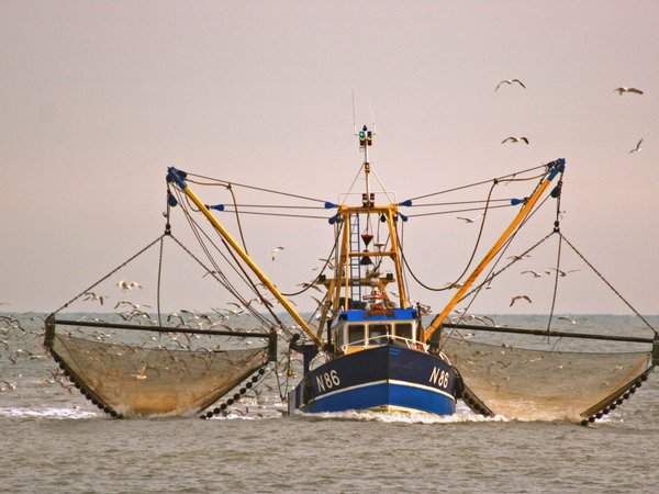
Fish and shellfish harvesting (professional and recreational) [Extraction of living resources]:
Article 4 of Annex V of the OSPAR Convention sets out that no programme or measure concerning a question relating to the management of fisheries must be adopted under that Annex. However, where the OSPAR Commission considers that action is desirable in relation to such a question, it must draw that question to the attention of the competent authority or international body. Where action within the competence of the OSPAR Commission is desirable to complement or support action by those authorities or bodies, the Commission must endeavor to cooperate with them.
One response to help facilitate this type of cooperation is the Collective Arrangement between competent international organisations on cooperation and coordination regarding selected areas in areas beyond national jurisdiction in the North-East Atlantic’ (Collective Arrangement, OSPAR Agreement 2014-09). This is a formal agreement between the legally competent authorities responsible for managing human activities in the ABNJs in the North-East Atlantic. To date, the Arrangement has been adopted by OSPAR and the North-East Atlantic Fisheries Commission (NEAFC) and focuses on selected geographic areas. In the case of OSPAR, the arrangement applies to the MPAs designated outside of national jurisdiction, and in the case of NEAFC, to certain areas with fishery closures; these areas are maintained as a list in Annex 1 to the Arrangement by the respective organisations. There is a strong overlap in these geographic regions enabling each organisation to act within its own field of competence in a manner that is coherent and complementary.
The Collective Arrangement has successfully provided a framework for productive informal dialogue, not only between OSPAR and NEAFC, but also with other relevant competent organisations. In 2017, a joint commitment was submitted under target 4.c of SDG 14 through which both Secretariats undertook to further promote the Collective Arrangement and widen its collaborative scope with the secretariats of intergovernmental organisations and bodies in other regions and sectors.
Please refer to Important measures taken by other competent bodies for more information about measures implemented by other competent organisations relevant to OSPAR’s work, and OSPAR Feeder Report 2021 - Fisheries .
Eutrophication (including from Agriculture)
Eutrophication results from excess nutrient and / or other organic enrichment and can lead to nuisance and toxic algal blooms, loss of benthic habitats through shading, and modification of benthic fauna communities due to specific sensitivities. Action to address eutrophication is a longstanding aspect of OSPAR’s work, triggered in response to serious eutrophication effects found in the 1970s and 1980s. Agreement was reached on a target reduction in nutrient inputs of the order of 50% between 1985 and 1995 (PARCOM Recommendation 88/2)
OSPAR measures and the subsequent implementation of measures adopted in the EU, the European Economic Area and other international forums have had some effect in improving the eutrophication status of the OSPAR Maritime Area (including the Urban Waste Water Treatment Directive (91/271/EEC); the Nitrates Directive (91/676/EEC); the Water Framework Directive (2000/60/EC); the Marine Strategy Framework Directive (2008/56/EC)).
The eutrophication status of the OSPAR Maritime Area has improved, and in the assessed Regions (Greater North Sea, Celtic Seas and the Bay of Biscay and Iberian Coast), benthic habitat status in relation to nutrient and / or organic enrichment is considered good, based on data reported for the EU WFD (See: Condition of Benthic Habitat Communities: Assessment of some Coastal Habitats in Relation to Nutrient and/or Organic Enrichment ). There are still regional variations and local problem areas, however, particularly in areas sensitive to nutrient inputs, such as estuaries, fjords and bights, and in areas affected by river plumes. Work to “Tackle eutrophication, through limiting inputs of nutrients and organic matter to levels that do not give rise to adverse effects on the marine environment” remains a strategic objective for OSPAR under NEAES 2030 (Strategic Objective 1). One of its operational objectives focuses on the application of nature-based solutions to safeguard the natural capacity of the ecosystem to sequester nutrients through the conservation and restoration of estuarine, coastal and marine habitats (S1.O6).
Renewable energy generation (wind, wave and tidal power), including infrastructure [Production of energy]:
Commitments to increase renewable energy production are leading to the rapid and, in some areas, extensive development of marine renewable infrastructure. There are several measures of relevance to the conservation and protection of benthic habitats, including some relating to environmental impact assessment and marine spatial planning as well as others specifically for guidance relating to the need to take nature conservation into account in renewable developments.
OSPAR produced guidance on the environmental considerations for offshore wind farm development in 2008 (OSPAR Agreement 2008-03). This guidance is aimed at approval authorities, to help them identify issues that may be associated with the environmental impacts of development at the operational and decommissioning stages. It covers the potential impacts for benthic habitats of different phases and elements of the structures, including power cables. The guidance also refers to other measures relevant to managing the impacts from the development of renewable energy infrastructure, including the EU Habitats Directive (Council Directive 92/43/EEC) and the Environmental Impact Assessment Directive (2014/52/EU). A 2020 survey of OSPAR Contracting Parties showed that the offshore wind guidance was generally fully implemented or that implementation was in progress, although not all Contracting Parties provided information for the survey. OSPAR also maintains a database of individual marine renewable developments, including tidal and wave, as well as offshore wind, installations.
The development of offshore renewable energy infrastructure may also have unintended consequences for benthic habitats, on the one hand by increasing hard substrate and reducing fishing with bottom-contacting gears, which could have a positive impact on benthic habitats; and on the other hand, by increasing hard substrate and possibly creating stepping stones to facilitate the movement of non-indigenous species. For OSPAR Contracting Parties that are also EU Member States, the European Commission’s offshore renewable energy strategy (Regulation 2020/741) refers to the Birds and Habitats Directives (Directive 2009/147/EC of the European Parliament and the Council and Council Directive 92/43/EEC, respectively) to ensure that developments do not have negative impacts on listed species or habitats, and that any potential impacts are reduced or minimised. Guidance has been developed under EU Commission notice C (2020) 7730 as well as in the Wildlife Sensitivity Mapping Manual, which provides practical guidance for renewable energy planning within the European Union. By 2023, OSPAR will develop common principles, and by 2024 develop guidance, for promoting and facilitating sustainable development and the scaling-up of offshore renewable energy in a way that minimises cumulative environmental impacts (S12.O4).
Extraction of minerals [Extraction of non-living resources]:
Aggregate extraction: OSPAR Agreement 2003-15 on sand and gravel extraction requires Contracting Parties which are coastal states of the Maritime Area to take the ICES Guidelines for the Management of Marine Sediment Extraction into account within their procedures for licensing the extraction of marine sediments (including sand and gravel). The Agreement encourages (i) the adoption of an ecosystem-based approach to the management of human activities in general plans for sediment extraction that are subject to strategic environmental assessment; and (ii) the placement of controls on the extraction of sediments from any ecologically-sensitive site. Mitigation could include measures such as seasonal closures for specific areas; the rotation of dredging intensity to allow the recolonisation and recovery of benthic habitats; and exploratory restoration techniques. The ICES guidelines are subject to a forthcoming review. See: OSPAR Feeder Report 2021 – Extraction of non-living resources
Deep-sea mining
Restructuring of seabed morphology, including dredging and deposit of materials
The dredging and dumping of waste and other matter have been well regulated since the Oslo Convention came into force in 1974. OSPAR has adopted guidelines for the management of dredged material at sea (OSPAR Agreement 2014-06) designed to assist Contracting Parties in the management of dredged material in ways that will prevent and eliminate pollution in accordance with Annex II to the 1992 OSPAR Convention, and to protect marine species and habitats in the OSPAR Maritime Area in accordance with Annex V. These set out a Best Environmental Practice approach for minimising both the amount of material dredged and the impacts of dredging and disposal. The guidelines include specific information on appropriate placement of dredged material in relation to the OSPAR List of threatened and /or declining species and habitats (OSPAR Agreement 2008-06). National authorities use these guidelines to manage dredging and dumping and to minimise effects on the marine environment. They also serve as a tool that Contracting Parties which are also EU Member States can use in managing dredged material that is subject to current European Directives (such as the Water Framework Directive 2000/60/EC, the Marine Strategy Framework Directive 2008/56/EC, and the Natura 2000 areas under the Birds and Habitat Directives 2009/147/EC and 92/43/EEC). Directive 2008/98/EC of the Parliament and of the Council of 19 November 2008, concerning waste (the Waste Framework Directive) has also been identified by the Contracting Parties as having implications for the management of dredged material, in addition to relevant national legislation.
Since 2000, the assessment and licensing procedures for dredged materials in most OSPAR countries have included action levels for contaminant loads based on the OSPAR guidelines. Since 1998, OSPAR has also had guidelines in place on the dumping of fish wastes (OSPAR Agreement 1998-21). The management of dredged material should respect the natural processes of sediment balance. Selecting the appropriate location for a dumpsite is essential in order to minimise environmental impact. Several dumpsites have been relocated after application of the OSPAR guidelines: a planned site in the Weser estuary was relocated after a site survey detected a mussel bank. Dumpsites have also been relocated or closed to avoid impacts on MPAs, fisheries and shipping. The ban on dumping vessels or aircraft has been implemented successfully.
A report on the use of the OSPAR guidelines was presented to OSPAR’s Environmental Impacts of Human Activities Committee (EIHA) in 2020. Reports from Contracting Parties have indicated that the 2014 dredging guidelines are being fully implemented in the greater part of the OSPAR Maritime Area (§6.46 Shipping and Ports Feeder Report ). Under NEAES 2030, OSPAR will assess, review and potentially revise the OSPAR criteria, guidelines and procedures relating to the dumping of wastes or other matter and to the placement of matter by 2023 (S7.O4).
Extraction of oil and gas including infrastructure [Extraction of non-living resources]:
Oil production activities have a localised impact on benthic habitats. While this activity is in decline, there are still more than 1 350 operational installations, with an increasing number reaching their end of life in the next two decades. A number of the OSPAR measures relating to the management of offshore oil and gas activities refer to the need to consider the impacts on habitats associated with construction, decommissioning or contamination during operation. Examples are OSPAR Decision 98/3 on the disposal of disused offshore installations and OSPAR Recommendation 2006/5 on a management regime for offshore cuttings piles. Measures taken under the offshore oil and gas strategy have had a high level of implementation, with reductions in the discharge of contaminants and fewer localised impacts recorded following the implementation of management regimes for offshore cuttings piles.
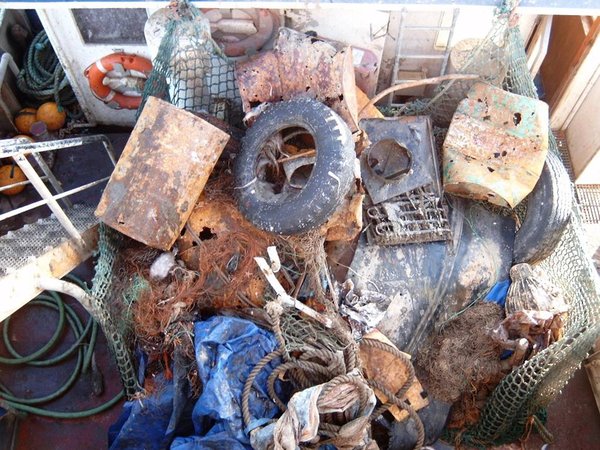
Marine litter
Marine Litter Thematic Assessment - Response
Marine litter can alter or degrade benthic habitats through physical disturbance, smothering or contamination (NOAA, 2016). Plastics and fishing gear account for most of the litter detected on the seafloor that is likely to cause harm to benthic habitats (see: Marine Litter Thematic Assessment – State ). In 2021, OSPAR concluded delivery of its First Regional Action Plan for Marine Litter (OSPAR Agreement 2014-01). Despite high engagement and the successful delivery of the actions under this plan, the quantities of marine litter in the North-East Atlantic remain high.
In 2022 OSPAR adopted the Second Regional Action Plan for Marine Litter (OSPAR Agreement 2022-05), which continues the drive towards achieving the NEAES Strategic Objective of preventing inputs of and significantly reducing marine litter, including actions to address harm from marine litter and the identification and removal of ghost fishing gear.
Transmission of electricity and communications (cables) [Production of energy]:
To date, no common programmes or measures have been developed by OSPAR with respect to the placement of sub-sea cables. There are, however, examples of requirements for assessment under national permit application procedures, including in respect of physical disturbance of benthic habitats or changes in community composition as a result of temperature changes. In Germany, for example, the nature conservation authorities have agreed on a maximum tolerable temperature increase threshold of 2 K in 20 cm depth in the sediment in German offshore areas, which requires the burial of cables at depths of approximately one metre and more. This 2 K value was considered appropriate as applying the precautionary approach to protect benthic organisms and communities from cable-induced temperature rises. The effectiveness of this measure has not yet been reported.
Scientific research [Education and research]:
Generating further scientific information about deep-sea ecosystems protected by MPAs is listed as one of the actions in the relevant management recommendations. The OSPAR code of conduct for responsible marine research in the deep seas and high seas of the OSPAR Maritime Area (OSPAR Agreement 2008-01) was adopted to facilitate this work and to ensure that minimum damage is caused to ecosystems through research activities. It includes guidance to “avoid, in the course of scientific research, activities which could lead to substantial physical, chemical, biological or geological changes or damage to marine habitats” and calls for the utmost care to ensure that OSPAR listed features are not disturbed or damaged. No information is requested on the state of implementation of this measure.
Marine aquaculture
OSPAR Feeder Report 2021 - Aquaculture
The primary measure for addressing the environmental impacts of marine aquaculture on benthic habitats, including impacts from contaminants and nutrient enrichment, is to take site-specific decisions on the location and management of aquaculture on the basis of assessments made of projects conducted under individual countries’ regulatory systems. OSPAR has taken few specific measures on aquaculture. OSPAR guidelines on the reporting of nutrient discharges / losses from marine and freshwater aquaculture plants were issued in 2004 and revised in 2018 (OSPAR, 2018). Under the Riverine Inputs and Direct Discharges (RID) programme there is some reporting of inputs from aquaculture (nutrients, heavy metals and certain organic pollutants). PARCOM Recommendation 94/6 covers the reduction of inputs from potentially toxic chemicals used in aquaculture, although reporting ceased in 2006. Since there are now significant developments in the aquaculture industry giving rise to concern about pollution, OSPAR decided in 2020 to initiate a new reporting round on Recommendation 94/6 in 2022.
Other relevant activities
Tourism and leisure infrastructure has been identified as an activity affecting benthic habitats, but no measures have been taken to address this. However, infrastructure development activities for tourism, transport or coastal defences will be subject to environmental impact assessment and covered by OSPAR Recommendation 2010/5.
Important measures taken by other competent bodies
This section highlights measures that have been taken by other competent bodies which complement OSPAR’s response for improving the state of benthic habitats within the North-East Atlantic.
General conservation measures
There are a number of general measures at the European level that are important in addressing the state of benthic habitats of the North-East Atlantic in the coastal zone and beyond, in particular Council Directive 92/43/EEC on the conservation of natural habitats and of wild fauna and flora (Habitats Directive), which includes the designation of a network of areas to protect habitats identified in its annex 1 and 2 (N2000); and the EU Water Framework Directive 2000/60/EC, which applies to coastal waters up to one nautical mile offshore and requires EU member states to take measures to prevent deterioration of the ecological and chemical status of waters, restore polluted waters, reduce pollution and cease or phase out inputs of hazardous substances. Directive 2014/89/EU establishing a framework for maritime spatial planning is seen as a tool to implement the ecosystem approach and is relevant to all human activities that could potentially affect benthic habitats; it is also intended to ensure that planning retains ecosystem benefits in terms of food production, recreation and tourism, climate change mitigation and adaptation, shoreline dynamics control and disaster prevention.
Benthic habitats are considered under Descriptor 1 (Biodiversity) of the Marine Strategy Framework Directive, which notes consistency with and connects to action under the Habitats Directive (including the Natura2000 network). EU member states are required to identify programmes of measures to be undertaken in order to achieve good environmental status in their waters, including for benthic habitats. Equivalent national frameworks, including programmes of measures, also exist in non-EU member states that are OSPAR Contracting Parties.
Another example within a sub-region of the Greater North Sea OSPAR Region is the Trilateral Wadden Sea Cooperation, an agreement between the Governments of Denmark, Germany and the Netherlands. This measure recognises the particular ecological value of this coastal area and the need to coordinate any responses to ensure conservation and sustainable management and maintain natural processes. The agreement aims to be consistent with the obligations under the EU Birds and Habitats Directives. The Dutch-German-Danish Wadden Sea has been placed on the UNESCO World Heritage List for its Outstanding Universal Value as the largest unbroken system of intertidal sand and mud flats in the world, with significance for biodiversity on a global scale, including Sabellaria reefs and seagrasses.
Fish and shellfish harvesting (professional and recreational) [Extraction of living resources]:
OSPAR Feeder Report 2021 - Fisheries
OSPAR does not itself have the competence to address questions relating to the management of fisheries. However, given that fisheries are a key human activity affecting the state of biodiversity, including in benthic habitats, OSPAR maintains a watching brief on responses taken to address fisheries management by the relevant competent organisations.
There is a global framework for fisheries management which establishes common principles, including conservation measures relating to vulnerable marine ecosystems (VME), a subset of which are included on the OSPAR List. These include United Nations General Assembly Resolution 64/72 on Sustainable fisheries and the UN Food and Agriculture Organization (FAO) International Guidelines for the management of deep-sea fisheries in the high seas, relating to deep-sea ecosystems.
Within the North-East Atlantic, the ICES has been advising relevant competent authorities, including the North-East Atlantic Fisheries Commission (NEAFC) and the EU, on the potential for damage to vulnerable habitats from fishing activity since the early 2000s. A number of measures have been taken, including some relating to gear restriction and to habitat protection through fishery closures.
In the context of the EU, a new regulation 2019/1241 on the conservation of fishery resources and the protection of marine ecosystems through technical measures was adopted to support the implementation of the EU Common Fisheries Policy. It addresses the reduction of ecosystem impacts (including on benthic habitats) through approaches such as closed areas and measures to regulate certain fishing gear. In addition, regulation EU 2016/2336 establishes specific conditions for fishing for deep-sea stocks in the North-East Atlantic and international waters, drawing on the best available scientific advice and setting out specific requirements to protect VMEs from fishing operations that use bottom-contacting gears between a depth of 400 and 800 m (ICES, 2021).
In areas beyond national jurisdiction, the NEAFC started to implement measures to address the possible adverse impacts of bottom fisheries in the early 2000s. In addition to the conservation of deep-sea fish species, these measures also aimed to address habitats or VMEs that are susceptible to lasting damage from bottom-contacting gear. A recommendation on the Protection of Vulnerable Marine Ecosystems in the NEAFC Regulatory Area is subject to periodic review, based on the latest scientific advice provided by the ICES, and the current amendment (Recommendation 10:2021) is in force until 31 December 2027. A 2019 review for the NEAFC concluded that implementation of its regulation on vulnerable marine environments had been largely effective; further action to improve monitoring and management advice has been agreed by the NEAFC (NEAFC, 2020). Continuing work by the ICES / NAFO (Northwest Atlantic Fisheries Organization) joint group on deep-water ecology is improving understanding of vulnerable ecosystems and the management tools needed to protect them (ICES, 2020).
Transport shipping [Physical damage / Pollution of oil and other noxious substances]:
The designation of Particularly Sensitive Sea Areas under Resolution A.982(24) on Revised guidelines for the identification and designation of Particularly Sensitive Sea Areas (PSSAs) is a response developed by the International Maritime Organization (IMO) to address potential environmental hazards from shipping, in particular in ecologically sensitive areas. These hazards are identified as relating to operational discharges, accidental or intentional pollution and physical disturbance to habitats. The impacts may include the smothering of habitats and contamination by anti-fouling systems or by other substances through groundings. Within the OSPAR Maritime Area, PSSAs have been designated in the Wadden Sea (2002) and in the Western European Waters (2004). No reports on the effectiveness of PSSAs for benthic habitats were found.
Extraction of minerals [Extraction of non-living resources]:
Deep-sea mining: The development of exploitation technology and mitigation or restorative techniques for deep-sea mining is at an early stage, and there are substantial gaps in our understanding of their effects. (Aggregates Feeder report §6.6).
The International Seabed Authority (ISA) is the competent organisation for the management of mining activities in the Area. The ISA is established under the 1982 United Nations Convention on the Law of the Sea (UNCLOS) and operationalised through the 1994 Agreement relating to the Implementation of Part XI of the United Nations Convention on the Law of the Sea. Through ISA, State Parties to UNCLOS shall organise and control all mineral-resources-related activities in the Area for the benefit of humankind as a whole. In doing so, ISA has the mandate to ensure the effective protection of the marine environment from harmful effects that may arise from such activities. The ISA uses i.a. Regional Environmental Management Plans as tools for the effective protection of the marine environment by establishing regional goals and objectives and providing a basis for decision making in a given geographic region. Regulations on prospecting and exploration for cobalt-rich ferromanganese crusts, polymetallic nodules and sulphides have been adopted by the ISA as of July 2012. The Council of the ISA is currently negotiating regulations for the potential exploitation of these minerals.
OSPAR and the ISA cooperate through an MoU (OSPAR Agreement 2010-09).
Regional differences
Within the Greater North Sea (Region II), Celtic Seas (Region III) and Bay of Biscay and Iberian Coast (Region IV) there are many measures in place aiming to reduce the pressures from human activities on the status of benthic habitats, especially where OSPAR Contracting Parties are also EU Member States. There are fewer such measures for Arctic Waters (Region I) and the Wider Atlantic (Region V), reflecting the lower pressures from human activities in these Regions. Actions to implement OSPAR measures at the national level are often also reported to fulfil other obligations, and vice versa (e.g., as collective actions under the MSFD), further complicating the task of understanding the added value of particular responses. In the Arctic Waters Region there are more national level responses.
Case Study: Arctic Waters
Norwegian national measures for holistic management of open seas marine ecosystems, including benthic habitats
Norway is not a member of the European Union and is not implementing the Marine Strategy Framework Directive (MSFD). Norway has developed and is taking measures for managing open seas marine ecosystems through holistic ecosystem-based plans, for all marine areas under Norwegian jurisdiction (Map 1). The area covered by the management plans is approximately 2,4 million km2 and constitutes a substantial part of OSPAR Region I. The area includes habitats ranging from near-coastal waters, open waters, deep sea plateaus, volcanic under-water mountain ridges, shelf seas and the polar ice region.
The management plans are tools for facilitating both value creation and food security, and for maintaining the high environmental value of Norway’s marine areas through the sustainable use of marine natural resources and ecosystem services. Value creation from ocean-based activities (Map 2), such as fisheries and aquaculture, shipping, petroleum activities and emerging new ocean industries, depends on maintaining good environmental status and high biodiversity in the marine and coastal environment, safeguarding the oceans as a source of food, and using ocean resources sustainably.
A set of particularly valuable and vulnerable areas (SVOs) has been identified as being of great importance for biodiversity and biological production; they form an entire management plan area (Map 1). The SVOs are selected using predefined criteria similar to those used in identifying ecologically or biologically significant marine areas (EBSAs) under the Convention on Biodiversity (CBD)[4]. They provide key guidance on where anthropogenic activities must be managed with particular care in order to avoid damage to ecosystem components, guide maritime planning and activities to minimise destructive impacts on the marine ecosystems and secure ecosystem hotspots of key importance to so as to maintain the rich productivity and biodiversity inside and beyond the Norwegian EEZ. For instance, the management plan for the Norwegian Sea (2008-2009) stated that Norway would map known coral habitats so that they could be more effectively protected against damage from fishing operations. This led to an extensive national seabed mapping effort, with the result that Norway (2021) has now registered more reefs of the coldwater coral Lophelia pertusa than any other country, most of them in the Norwegian Sea[1].
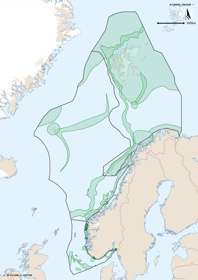
Map 1: Outlines of the Norwegian EEZ, separated into North Sea, Norwegian Sea and Barents Sea areas, with green shading indicating current SVOs. Taken from [1]
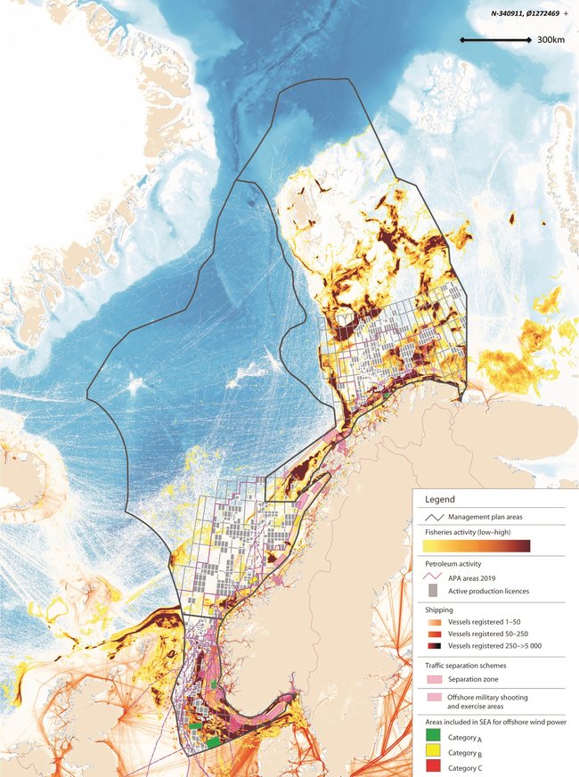
Map 2: Overview of ocean-based activities in the management plan areas. Taken from [1]
Marine Protected Areas
The management plans clarify an overall framework for ocean-based industries and set out measures for the conservation and sustainable use of marine ecosystems. They encourage closer coordination and clear priorities for the management of Norway’s marine areas. The various sectoral authorities are responsible for implementing the measures set out in the management plans, under relevant legislation that they administer. In addition, a White Paper on the protection of marine nature was published in 2021 (Maps 3a, b).
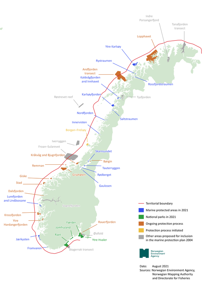
Map 3a: Existing (blue/green), planned (dark/light orange) and suggested (grey) MPAs in Norway as well as selected MPAs for the protection of coral reefs (red crossbars). The red full line is the 12 nm territorial line. Taken from [2]
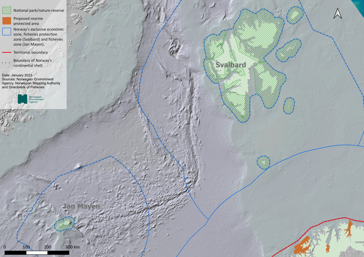
Map 3b: Marine national parks at Svalbard and in the open sea (green crossbars). The red full line is the 12 nm territorial lines. Taken from [2]
Habitat protected areas
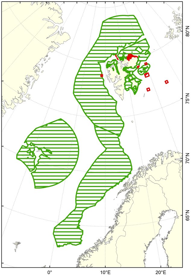
The protection of cold-water coral reefs from smothering and other damage from fishing activities, has resulted in a series of small, local protection zones (Map 4). The protection of major cold-water coral reefs is in accordance with some of the measures under the OSPAR Recommendation on Lophelia reefs.

Map 4: Protective areas (red cross-barred boxes) and known and documented coral reefs (orange dots) along the Norwegian coastal shelf and the slope towards the deep-sea basins. The red full line is the 12 nm territorial lines. Taken from [2]
Fisheries restricted areas
Besides the protective areas in Map 4, area closures are also in effect to protect vulnerable bottom habitats and vulnerable species in Norway's sea areas. Map 5 shows the large areas closed to protect vulnerable bottom habitats (more information in [5]). Many areas are closed to bottom fisheries to protect juveniles of commercial species, and some of them are dynamic in space and time. Such areas are not included in this case study.
Map 5: Sea areas closed to bottom fisheries (green crossbars) and no-fishing boxes in fishing fields (red boxes). Source: The Norwegian Directorate of Fisheries database "Yggdrasil", January 2023
The areas closed in order to protect vulnerable species include the 56 areas closed to protect lobster along the southern coastline. The first lobster reserves were established in 2002, with a successful outcome[3]. Since then, more such reserves for lobster protection have been planned and established by coastal municipalities, building on the positive impact documented over the past 20 years.
[1] Norway’s integrated ocean management plans — Barents Sea–Lofoten area; the Norwegian Sea; and the North Sea and Skagerrak — Report to the Storting (white paper): https://www.regjeringen.no/en/dokumenter/meld.-st.-20-20192020/id2699370/
[2] Norway’s integrated plan for the conservation of areas of special importance for marine biodiversity: Meld. St. 29 (2020–2021) - regjeringen.no
[3] Knutsen et al., 2022: https://www.sciencedirect.com/science/article/pii/S0308597X21005194
[4] EBSA-publication: Azores Scientific Criteria and Guidance for identifying ecologically or biologically significant marine areas and designing representative networks of marine protected areas in open ocean waters and deep sea habitats: https://www.cbd.int/doc/meetings/mar/ebsaws-2014-01/other/ebsaws-2014-01-azores-brochure-en.pdf. [See annex I, decision IX/20]
[5] Jørgensen et al., 2020: Responding to global warming: New fisheries management measures in the Arctic - ScienceDirect. https://doi.org/10.1016/j.pocean.2020.102423
In the deep seas and areas outside of national jurisdiction, the main response from OSPAR has been to designate MPAs to protect particular benthic features. However, the competence to manage the main human activities of concern that may take place in those areas lies with other organisations, and initiatives such as the Collective Arrangement will need to be strengthened in order to ensure coordination and consistency in achieving conservation and management objectives.
Gaps and opportunities
Are we doing enough?:
On the whole, benthic habitats in the North-East Atlantic continue to be in a poor state, and so the short answer is that the current suite of measures being implemented does not seem to have improved the status of benthic habitats, in particular within EEZs.
It is not possible to answer the question whether these measures are able to reduce the pressures and human activities that continue to undermine benthic habitats in the North-East Atlantic. There are several reasons why this is the case, including how the measures have been designed and how they are reported upon. Many measures are developed to address multiple activities and pressures, and unless the reporting is very explicit, it is not easy, and in many cases impossible, to disaggregate which action addresses which activity or pressure; the same action may be reported as a response to multiple measures.
Are there other types of responses that could be undertaken by OSPAR to improve the status of benthic habitats?:
In 2010, OSPAR ministers committed to halting the decline of species and habitats, with the strategic objective of preventing further loss by 2020, in particular by restoring threatened and / or declining species and habitats through measures designed to protect them from the pressures of human activities (Bergen statement §24). Restoration has been included as a national action in three of the OSPAR Recommendations on actions to address habitats on the OSPAR List (Ostrea edulis beds, kelp forest, intertidal mudflats), and currently no collective actions have been taken. There is a need and opportunity for OSPAR to progress the development of responses relating to restoration of degraded habitats, as an integral part of a management approach to reduce pressures and restore vulnerable ecosystems. This need is recognised in the Cascais Ministerial Declaration (2021), under which OSPAR (§23) commits to playing an ambitious role in the CBD Post-2020 Global Biodiversity Framework that establishes a target for the restoration of ecosystems, including marine ones, as well as in the context of the UN Decade for Ecosystem Restoration. The implementation of this ambition is articulated in NEAES 2030, through a specific strategic objective to restore degraded ecosystems and the operational objectives mentioned below:
Strategic Objective 6: Restore degraded habitats in the North-East Atlantic when practicable to safeguard their ecosystem function and resilience to climate change and ocean acidification.
S6.O1 By 2023 OSPAR will identify habitats suitable for restoration, and develop a common knowledge base on the most appropriate and effective methods for restoration of degraded habitats.
S6.O2 By 2025 OSPAR will develop a regional approach, including relevant qualitative and / or quantitative targets for restoration of degraded habitats suitable for restoration, and will then implement actions to achieve the targets as appropriate.
In addition, there are two other operational objectives that reference restoration of benthic habitats.
S1.O6 By 2030 OSPAR will develop and implement a regional approach to applying nature-based solutions to reinstate and safeguard the natural capacity of the ecosystem to sequester nutrients through conservation and restoration of estuarine, coastal and marine habitats, where this is practicable.
S12.O1 By 2025 OSPAR will develop a regional approach to applying nature-based solutions for carbon storage and implement specific measures to protect and restore relevant carbon sequestration and storage habitats, such as seagrass beds, kelp forests and saltmarshes.
Restoration will also support delivery of another operational objective by strengthening the blue carbon potential and the ambition for OSPAR to take nature-based carbon storage into account by 2025 when reviewing the criteria for the designation of marine protected areas and reviewing the OSPAR List of threatened and / or declining species and habitats (S12.O2).
FAO (2009). International Guidelines for the Management of Deep-sea Fisheries in the High Seas. Rome. 73pp. https://www.fao.org/docrep/011/i0816t/i0816t00.HTM
ICES (2020). ICES/NAFO Joint Working Group on Deep-water Ecology (WGDEC). ICES Scientific Reports. 2:62. 171 pp. Available at: http://doi.org/10.17895/ices.pub.6095
ICES (2021) EU Request to advise on the list of areas where VMEs are known to occur or are likely to occur and on the existing deep-sea fishing areas (ref. (EU)2016/2336)
NOAA, National Oceanic and Atmospheric Administration Marine Debris Program. (2016). Report on Marine Debris Impacts on Coastal and Benthic Habitats. Silver Spring, MD: National Oceanic and Atmospheric Administration Marine Debris Program.
NEAFC (2020). Submission by NEAFC to a UN report on actions addressing the impacts of bottom fishing on vulnerable marine ecosystems and the long-term sustainability of the deep-sea fish stocks. Available at: https://www.neafc.org/other/31810
| Impact | Cumulative Effects |